TopoQuest Logo
Do you find TopoQuest useful?
Help keep TopoQuest running and adding new maps/features by donating!
Bitcoin:  19c7KJd3qBynnjoSw5npx9KScwjBe4ifkT
Litecoin:  LXs6TkuXGGXo1vDsWCkWVdjQX94eUKd6ui
Home View Maps Find Maps Find Places Resources & Links


Pollard, Alabama Topographic Map

USGS Map Title: Pollard, AL
USGS Map MRC: 31087A2
DRG (GeoTIFF) Download: o31087a2.tif


Neighboring USGS Topographic Map Quads:


  Barnett Crossroads, AL  
31087B3
 

  Wallace, AL  
31087B2
 

  Brewton North, AL  
31087B1
 

  Flomaton, AL  
31087A3
 

  Pollard, AL  
31087A2
 

  Brewton South, AL  
31087A1
 

  Century, FL  
30087H3
 

  Jay, FL  
30087H2
 

  Fidelis, FL  
30087H1


Map MRC Location:

N32°
W88°
N32°
W87°
H8 H7 H6 H5 H4 H3 H2 H1
G8 G7 G6 G5 G4 G3 G2 G1
F8 F7 F6 F5 F4 F3 F2 F1
E8 E7 E6 E5 E4 E3 E2 E1
D8 D7 D6 D5 D4 D3 D2 D1
C8 C7 C6 C5 C4 C3 C2 C1
B8 B7 B6 B5 B4 B3 B2 B1
A8 A7 A6 A5 A4 A3 A2 A1
N31°
W88°
N31°
W87°

Pollard, AL USGS 1:24K Topographic Map Preview:
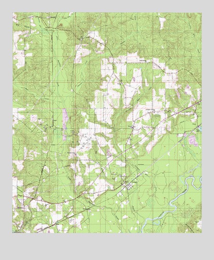
Pollard, AL USGS Topographic Map
Click on map above to begin viewing in our Map Viewer.

This topographic map contains these locations and features:
Feature Name Type Latitude Longitude GNIS ID View Map
Barrylum (historical)LocaleN31.0696°W87.2233°133750View Map
Bay BranchStreamN31.0077°W87.1616°113582View Map
Beulah ChurchChurchN31.0849°W87.1794°114177View Map
Catawba Springs Baptist ChurchChurchN31.0691°W87.1569°155858View Map
Catawba Springs CemeteryCemeteryN31.0682°W87.1364°115698View Map
Catawba Springs Oil FieldOilfieldN31.0718°W87.1577°151177View Map
Chavers CreekStreamN31.0746°W87.2169°115986View Map
Chavers Creek Oil FieldOilfieldN31.0816°W87.2116°151178View Map
Fanny ChurchChurchN31.0155°W87.2289°118197View Map
Fanny Church Oil FieldOilfieldN31.0124°W87.2350°151179View Map
FosheePopulated PlaceN31.1168°W87.2264°156369View Map
Friendship ChurchChurchN31.0557°W87.1955°133801View Map
Friendship Volunteer Fire DepartmentBuildingN31.0410°W87.2075°2331085View Map
Green Acres Memorial ParkCemeteryN31.0682°W87.1550°119324View Map
Hall CreekStreamN31.0746°W87.2169°119582View Map
HammacPopulated PlaceN31.1224°W87.2230°156448View Map
Henderson CemeteryCemeteryN31.0074°W87.1280°119948View Map
Hillcrest CemeteryCemeteryN31.0318°W87.1789°120117View Map
Hollywood CemeteryCemeteryN31.0063°W87.2116°120287View Map
Jernigan LakeReservoirN31.0448°W87.1856°129624View Map
Jernigan Mill CreekStreamN31.0088°W87.1600°120865View Map
Journagans and McLeans Steam Mill (historical)LocaleN31.0232°W87.2075°133815View Map
KeegoPopulated PlaceN31.0607°W87.1275°121094View Map
Lighthouse Baptist ChurchChurchN31.0171°W87.2171°2580363View Map
Little Escambia Creek Oil FieldOilfieldN31.0127°W87.1819°151184View Map
McCall Volunteer Fire DepartmentBuildingN31.0693°W87.1574°2331053View Map
Mount Carmel Springs BranchStreamN31.0127°W87.1433°294092View Map
Narrow Gap CreekStreamN31.1132°W87.2228°123642View Map
New Home ChurchChurchN31.1060°W87.1414°134645View Map
Oak Grove ChurchChurchN31.0677°W87.1716°124071View Map
OsakaPopulated PlaceN31.0638°W87.2239°156844View Map
Pleasant Home ChurchChurchN31.0443°W87.2086°125019View Map
PollardPopulated PlaceN31.0271°W87.1736°125105View Map
Pollard - McCall Junior High SchoolSchoolN31.0601°W87.1706°165474View Map
Pollard CemeteryCemeteryN31.0302°W87.1819°125107View Map
Pollard Junior High School (historical)SchoolN31.0221°W87.1730°154701View Map
Pollard United Methodist ChurchChurchN31.0259°W87.1715°2580365View Map
Randolph Jernigan DamDamN31.0452°W87.1866°129623View Map
Shady Grove ChurchChurchN31.0960°W87.1819°133876View Map
South Bethel Church of GodChurchN31.0968°W87.1614°155794View Map
Town of PollardCivilN31.0235°W87.1736°2407141View Map
WahlPopulated PlaceN31.0052°W87.2214°157206View Map
WelkaPopulated PlaceN31.0135°W87.2008°157229View Map
Wild BranchStreamN31.1160°W87.2319°128954View Map
Wild Fork CreekStreamN31.1218°W87.2197°128956View Map

Note: Coordinates in the location and feature list above are referenced to NAD83 datum.


Copyright (C) 2008-2024 Ryan Niemi / Sunset Dynamics ... All Rights Reserved