TopoQuest Logo
Do you find TopoQuest useful?
Help keep TopoQuest running and adding new maps/features by donating!
Bitcoin:  19c7KJd3qBynnjoSw5npx9KScwjBe4ifkT
Litecoin:  LXs6TkuXGGXo1vDsWCkWVdjQX94eUKd6ui
Home View Maps Find Maps Find Places Resources & Links


Polkville, Kentucky Topographic Map

USGS Map Title: Polkville, KY
USGS Map MRC: 36086H3
DRG (GeoTIFF) Download: o36086h3.tif


Neighboring USGS Topographic Map Quads:


  Bowling Green North, KY  
37086A4
 

  Bristow, KY  
37086A3
 

  Smiths Grove, KY  
37086A2
 

  Bowling Green South, KY  
36086H4
 

  Polkville, KY  
36086H3
 

  Meador, KY  
36086H2
 

  Drake, KY  
36086G4
 

  Allen Springs, KY  
36086G3
 

  Scottsville, KY  
36086G2


Map MRC Location:

N37°
W87°
N37°
W86°
H8 H7 H6 H5 H4 H3 H2 H1
G8 G7 G6 G5 G4 G3 G2 G1
F8 F7 F6 F5 F4 F3 F2 F1
E8 E7 E6 E5 E4 E3 E2 E1
D8 D7 D6 D5 D4 D3 D2 D1
C8 C7 C6 C5 C4 C3 C2 C1
B8 B7 B6 B5 B4 B3 B2 B1
A8 A7 A6 A5 A4 A3 A2 A1
N36°
W87°
N36°
W86°

Polkville, KY USGS 1:24K Topographic Map Preview:
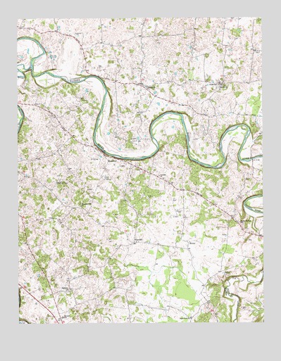
Polkville, KY USGS Topographic Map
Click on map above to begin viewing in our Map Viewer.

This topographic map contains these locations and features:
Feature Name Type Latitude Longitude GNIS ID View Map
Alvaton DivisionCivilN36.8848°W86.3365°1937023View Map
Alvaton SchoolSchoolN36.8775°W86.3522°485917View Map
Alvaton Volunteer Fire Department Station 1BuildingN36.8765°W86.3539°2637000View Map
Alvaton Volunteer Fire Department Station 2BuildingN36.9390°W86.3136°2636999View Map
Bays Fork ChurchChurchN36.8767°W86.2869°486498View Map
Berea ChurchChurchN36.9723°W86.2707°486898View Map
Bethany ChurchChurchN36.8892°W86.3486°486931View Map
Bethel ChurchChurchN36.9712°W86.3083°486965View Map
Cassidy ChurchChurchN36.9353°W86.3028°489062View Map
Collett (historical)Populated PlaceN36.9947°W86.3648°2742798View Map
Drakes CreekStreamN36.9806°W86.3675°491096View Map
Gilmore CemeteryCemeteryN36.9209°W86.2914°492853View Map
Gott Volunteer Fire DepartmentBuildingN36.9730°W86.3138°2636998View Map
GottsPopulated PlaceN36.9728°W86.3139°493053View Map
GreenhillPopulated PlaceN36.9081°W86.3158°508132View Map
HardcastlePopulated PlaceN36.9417°W86.3289°508180View Map
Iron BridgeBridgeN36.9420°W86.2553°495005View Map
Kimbrough CemeteryCemeteryN36.9934°W86.3450°495731View Map
MotleyPopulated PlaceN36.9075°W86.2880°508637View Map
Petty CemeteryCemeteryN36.9800°W86.3314°500488View Map
Pleasant Hill ChurchChurchN36.9228°W86.3430°500853View Map
PolkvillePopulated PlaceN36.9725°W86.2708°501005View Map
Rocky Springs SchoolSchoolN36.9162°W86.2619°502266View Map
Thomas CemeteryCemeteryN36.9353°W86.3314°505160View Map
Trammel CreekStreamN36.8756°W86.3744°505463View Map

Note: Coordinates in the location and feature list above are referenced to NAD83 datum.


Copyright (C) 2008-2024 Ryan Niemi / Sunset Dynamics ... All Rights Reserved