TopoQuest Logo
Do you find TopoQuest useful?
Help keep TopoQuest running and adding new maps/features by donating!
Bitcoin:  19c7KJd3qBynnjoSw5npx9KScwjBe4ifkT
Litecoin:  LXs6TkuXGGXo1vDsWCkWVdjQX94eUKd6ui
Home View Maps Find Maps Find Places Resources & Links


Pocasset, Oklahoma Topographic Map

USGS Map Title: Pocasset, OK
USGS Map MRC: 35097B8
DRG (GeoTIFF) Download: o35097b8.tif


Neighboring USGS Topographic Map Quads:


  Cogar SE, OK  
35098C1
 

  Minco, OK  
35097C8
 

  Tuttle, OK  
35097C7
 

  Anadarko NE, OK  
35098B1
 

  Pocasset, OK  
35097B8
 

  Chickasha NE, OK  
35097B7
 

  Verden, OK  
35098A1
 

  Chickasha, OK  
35097A8
 

  Tabler, OK  
35097A7


Map MRC Location:

N36°
W98°
N36°
W97°
H8 H7 H6 H5 H4 H3 H2 H1
G8 G7 G6 G5 G4 G3 G2 G1
F8 F7 F6 F5 F4 F3 F2 F1
E8 E7 E6 E5 E4 E3 E2 E1
D8 D7 D6 D5 D4 D3 D2 D1
C8 C7 C6 C5 C4 C3 C2 C1
B8 B7 B6 B5 B4 B3 B2 B1
A8 A7 A6 A5 A4 A3 A2 A1
N35°
W98°
N35°
W97°

Pocasset, OK USGS 1:24K Topographic Map Preview:
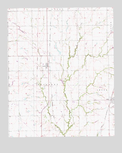
Pocasset, OK USGS Topographic Map
Click on map above to begin viewing in our Map Viewer.

This topographic map contains these locations and features:
Feature Name Type Latitude Longitude GNIS ID View Map
AmberPopulated PlaceN35.1603°W97.8792°1089607View Map
Amber - Pocasset Elementary SchoolSchoolN35.1926°W97.9550°1089609View Map
Amber - Pocasset Junior High SchoolSchoolN35.1599°W97.8753°2712799View Map
Amber CemeteryCemeteryN35.1594°W97.9002°1089608View Map
Amber Police DepartmentBuildingN35.1606°W97.8772°2757936View Map
Amber Volunteer Fire DepartmentBuildingN35.1605°W97.8774°2658587View Map
Oknoname 051021 DamDamN35.1634°W97.9803°1753680View Map
Oknoname 051021 ReservoirReservoirN35.1619°W97.9805°1753681View Map
Oknoname 051022 DamDamN35.2051°W97.9387°1751168View Map
Oknoname 051022 ReservoirReservoirN35.2072°W97.9394°1751169View Map
Oknoname 051023 DamDamN35.2101°W97.9420°1753682View Map
Oknoname 051023 ReservoirReservoirN35.2101°W97.9420°1753683View Map
Oknoname 051024 DamDamN35.2267°W97.9303°1753684View Map
Oknoname 051024 ReservoirReservoirN35.2294°W97.9301°1753685View Map
Oknoname 051025 DamDamN35.2317°W97.9437°1753686View Map
Oknoname 051025 ReservoirReservoirN35.2316°W97.9447°1753687View Map
PocassetPopulated PlaceN35.1937°W97.9525°1096791View Map
Pocasset CemeteryCemeteryN35.1822°W97.9532°1096792View Map
Pocasset Volunteer Fire DepartmentBuildingN35.1968°W97.9523°2658590View Map
Town of AmberCivilN35.1602°W97.8821°2412360View Map
Town of PocassetCivilN35.1780°W97.9592°2412493View Map
Township of PocassetCivilN35.1751°W97.9531°1825318View Map
West Fork Salt CreekStreamN35.1276°W97.9362°1099560View Map

Note: Coordinates in the location and feature list above are referenced to NAD83 datum.


Copyright (C) 2008-2024 Ryan Niemi / Sunset Dynamics ... All Rights Reserved