TopoQuest Logo
Do you find TopoQuest useful?
Help keep TopoQuest running and adding new maps/features by donating!
Bitcoin:  19c7KJd3qBynnjoSw5npx9KScwjBe4ifkT
Litecoin:  LXs6TkuXGGXo1vDsWCkWVdjQX94eUKd6ui
Home View Maps Find Maps Find Places Resources & Links


Plainfield, Wisconsin Topographic Map

USGS Map Title: Plainfield, WI
USGS Map MRC: 44089B4
DRG (GeoTIFF) Download: o44089b4.tif


Neighboring USGS Topographic Map Quads:


  Bancroft, WI  
44089C5
 

  Almond, WI  
44089C4
 

  Blaine, WI  
44089C3
 

  Hancock, WI  
44089B5
 

  Plainfield, WI  
44089B4
 

  Wautoma NE, WI  
44089B3
 

  Coloma, WI  
44089A5
 

  Richford, WI  
44089A4
 

  Wautoma, WI  
44089A3


Map MRC Location:

N45°
W90°
N45°
W89°
H8 H7 H6 H5 H4 H3 H2 H1
G8 G7 G6 G5 G4 G3 G2 G1
F8 F7 F6 F5 F4 F3 F2 F1
E8 E7 E6 E5 E4 E3 E2 E1
D8 D7 D6 D5 D4 D3 D2 D1
C8 C7 C6 C5 C4 C3 C2 C1
B8 B7 B6 B5 B4 B3 B2 B1
A8 A7 A6 A5 A4 A3 A2 A1
N44°
W90°
N44°
W89°

Plainfield, WI USGS 1:24K Topographic Map Preview:
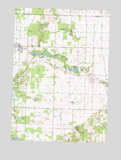
Plainfield, WI USGS Topographic Map
Click on map above to begin viewing in our Map Viewer.

This topographic map contains these locations and features:
Feature Name Type Latitude Longitude GNIS ID View Map
Bullhead LakeLakeN44.1464°W89.4929°1562399View Map
Camp ChapelChurchN44.1253°W89.4879°1562589View Map
Fiddle LakeLakeN44.2027°W89.4344°1564927View Map
Fish Lake CemeteryCemeteryN44.1252°W89.4712°1565005View Map
Hancock ParkParkN44.1283°W89.4976°1566030View Map
Herrick LakeLakeN44.1641°W89.4669°1566326View Map
Hillside CemeteryCemeteryN44.2141°W89.4765°1566460View Map
Horsehead LakeLakeN44.2033°W89.4391°1566717View Map
Kawalski LakeLakeN44.2307°W89.4331°1567368View Map
Lake HuronLakeN44.1934°W89.4180°1566823View Map
Long LakeLakeN44.2069°W89.4553°1584507View Map
Lord CemeteryCemeteryN44.1814°W89.3784°1568638View Map
Mud LakeLakeN44.1940°W89.4080°1569922View Map
North Deerfield CemeteryCemeteryN44.1555°W89.4504°1570418View Map
Oasis CemeteryCemeteryN44.1825°W89.3948°1570731View Map
Piper LakeLakeN44.2259°W89.4250°1571554View Map
PlainfieldPopulated PlaceN44.2139°W89.4923°1571576View Map
Plainfield Baptist ChurchChurchN44.2122°W89.4910°1845692View Map
Plainfield Fire DepartmentBuildingN44.2127°W89.4929°2697576View Map
Plainfield International AirportAirportN44.2216°W89.4936°2444158View Map
Plainfield LakeLakeN44.2067°W89.4725°1571578View Map
Plainfield Police DepartmentBuildingN44.2127°W89.4928°2759950View Map
Plainfield Tunnel Channel Lakes State Natural AreaParkN44.2083°W89.4651°2061063View Map
Pumpkin Seed LakeLakeN44.2051°W89.4464°1571972View Map
Ray CemeteryCemeteryN44.2139°W89.4661°1572109View Map
Reeder LakeLakeN44.1455°W89.4867°1572169View Map
Saint Pauls Catholic ChurchChurchN44.2086°W89.4896°1845702View Map
Saint Pauls CemeteryCemeteryN44.2277°W89.4768°1573468View Map
Sand LakeLakeN44.1661°W89.4972°1573688View Map
Second LakeLakeN44.2071°W89.4657°1573873View Map
Sherman LakeLakeN44.2044°W89.4623°1574028View Map
Shumway LakeLakeN44.1936°W89.4249°1574084View Map
Slafter LakeLakeN44.1628°W89.4227°1574264View Map
Town of OasisCivilN44.1999°W89.4235°1583846View Map
Tri - County Elementary SchoolSchoolN44.2099°W89.4947°2716892View Map
Tri - County High SchoolSchoolN44.2111°W89.4947°1845707View Map
Tri - County Middle SchoolSchoolN44.2105°W89.4947°2716681View Map
Village of PlainfieldCivilN44.2179°W89.4973°1583931View Map
Walters LakeLakeN44.2297°W89.4268°1576183View Map
Weymouth LakeLakeN44.1951°W89.4302°1576593View Map
Yonke LakeLakeN44.2343°W89.4619°1577102View Map

Note: Coordinates in the location and feature list above are referenced to NAD83 datum.


Copyright (C) 2008-2024 Ryan Niemi / Sunset Dynamics ... All Rights Reserved