TopoQuest Logo
Do you find TopoQuest useful?
Help keep TopoQuest running and adding new maps/features by donating!
Bitcoin:  19c7KJd3qBynnjoSw5npx9KScwjBe4ifkT
Litecoin:  LXs6TkuXGGXo1vDsWCkWVdjQX94eUKd6ui
Home View Maps Find Maps Find Places Resources & Links


Pinetops, North Carolina Topographic Map

USGS Map Title: Pinetops, NC
USGS Map MRC: 35077G6
DRG (GeoTIFF) Download: o35077g6.tif


Neighboring USGS Topographic Map Quads:


  Rocky Mount, NC  
35077H7
 

  Hartsease, NC  
35077H6
 

  Tarboro, NC  
35077H5
 

  Elm City, NC  
35077G7
 

  Pinetops, NC  
35077G6
 

  Old Sparta, NC  
35077G5
 

  Saratoga, NC  
35077F7
 

  Fountain, NC  
35077F6
 

  Falkland, NC  
35077F5


Map MRC Location:

N36°
W78°
N36°
W77°
H8 H7 H6 H5 H4 H3 H2 H1
G8 G7 G6 G5 G4 G3 G2 G1
F8 F7 F6 F5 F4 F3 F2 F1
E8 E7 E6 E5 E4 E3 E2 E1
D8 D7 D6 D5 D4 D3 D2 D1
C8 C7 C6 C5 C4 C3 C2 C1
B8 B7 B6 B5 B4 B3 B2 B1
A8 A7 A6 A5 A4 A3 A2 A1
N35°
W78°
N35°
W77°

Pinetops, NC USGS 1:24K Topographic Map Preview:
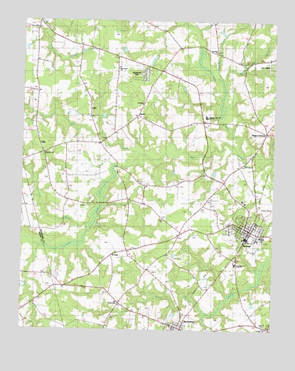
Pinetops, NC USGS Topographic Map
Click on map above to begin viewing in our Map Viewer.

This topographic map contains these locations and features:
Feature Name Type Latitude Longitude GNIS ID View Map
Batts PondReservoirN35.7685°W77.6830°999389View Map
Beaverdam BranchStreamN35.8515°W77.6514°1003802View Map
Bethlehem ChurchChurchN35.8415°W77.6900°1003809View Map
Bynums Mill RunStreamN35.7557°W77.6589°982361View Map
Carver Elementary SchoolSchoolN35.7882°W77.6308°1003592View Map
Cokey SwampStreamN35.8271°W77.6478°1019722View Map
Corn CreekStreamN35.8215°W77.6914°1003804View Map
CrispPopulated PlaceN35.7507°W77.6253°1023929View Map
Eagles ChurchChurchN35.7524°W77.6300°1003805View Map
Faith ChurchChurchN35.8393°W77.7155°1003807View Map
Fox HollowPopulated PlaceN35.8574°W77.6253°1003981View Map
Hazelwood ParkPopulated PlaceN35.8529°W77.6894°1003980View Map
LancasterPopulated PlaceN35.8582°W77.6930°988121View Map
Lewis Community Volunteer Fire DepartmentBuildingN35.8590°W77.6329°2639270View Map
Lower Town Creek ChurchChurchN35.8179°W77.6394°1007576View Map
MacclesfieldPopulated PlaceN35.7521°W77.6700°1024124View Map
Macclesfield Post OfficePost OfficeN35.7521°W77.6717°2773929View Map
MacClesfield Rural Volunteer Fire DepartmentBuildingN35.7514°W77.6724°2639838View Map
McDowell County PlazaLocaleN35.7521°W77.6711°1007271View Map
McKendree ChurchChurchN35.8627°W77.6539°1003811View Map
MercerPopulated PlaceN35.8368°W77.6930°989730View Map
Morning Star ChurchChurchN35.8554°W77.7028°1003810View Map
NC Noname Eight-Hundred FortyDamN35.7685°W77.6830°999388View Map
PinetopsPopulated PlaceN35.7885°W77.6378°1021938View Map
Pinetops Police DepartmentBuildingN35.7913°W77.6374°2130989View Map
Pinetops Post OfficePost OfficeN35.7908°W77.6383°2773814View Map
Pinetops Volunteer Fire DepartmentBuildingN35.7903°W77.6388°2639692View Map
Pitt CrossroadsLocaleN35.7610°W77.7008°1003813View Map
Pyatts ChapelChurchN35.8252°W77.7408°1003806View Map
Saint LewisPopulated PlaceN35.7815°W77.7030°1022461View Map
Sasnett Mill BranchStreamN35.8535°W77.6533°1024291View Map
South Edgecombe Junior High SchoolSchoolN35.7771°W77.6433°1007577View Map
South Edgecombe Rural Fire DepartmentBuildingN35.7903°W77.6386°2638274View Map
Southwest Edgecombe High SchoolSchoolN35.8374°W77.6590°1003812View Map
Temperance HallChurchN35.8213°W77.7394°1003808View Map
Town of MacclesfieldCivilN35.7522°W77.6703°2406070View Map
Town of PinetopsCivilN35.7913°W77.6378°2407122View Map
Township 10-Lower Town CreekCivilN35.7886°W77.6721°1026667View Map
Township 13-CokeyCivilN35.8438°W77.7077°1026670View Map
Triangle Sand QuarryMineN35.7997°W77.7181°2649305View Map
Wiggins CrossroadsPopulated PlaceN35.8310°W77.6300°997291View Map
Williamson BranchStreamN35.7882°W77.7225°997397View Map

Note: Coordinates in the location and feature list above are referenced to NAD83 datum.


Copyright (C) 2008-2024 Ryan Niemi / Sunset Dynamics ... All Rights Reserved