TopoQuest Logo
Do you find TopoQuest useful?
Help keep TopoQuest running and adding new maps/features by donating!
Bitcoin:  19c7KJd3qBynnjoSw5npx9KScwjBe4ifkT
Litecoin:  LXs6TkuXGGXo1vDsWCkWVdjQX94eUKd6ui
Home View Maps Find Maps Find Places Resources & Links


Pine City, Minnesota Topographic Map

USGS Map Title: Pine City, MN
USGS Map MRC: 45092G8
DRG (GeoTIFF) Download: o45092g8.tif


Neighboring USGS Topographic Map Quads:


  Brook Park, MN  
45093H1
 

  Beroun, MN  
45092H8
 

  Cedar Lake, MN  
45092H7
 

  Henriette, MN  
45093G1
 

  Pine City, MN  
45092G8
 

  Bass Creek, MN  
45092G7
 

  Rush Lake, MN  
45093F1
 

  Rush City, MN  
45092F8
 

  Randall, WI  
45092F7


Map MRC Location:

N46°
W93°
N46°
W92°
H8 H7 H6 H5 H4 H3 H2 H1
G8 G7 G6 G5 G4 G3 G2 G1
F8 F7 F6 F5 F4 F3 F2 F1
E8 E7 E6 E5 E4 E3 E2 E1
D8 D7 D6 D5 D4 D3 D2 D1
C8 C7 C6 C5 C4 C3 C2 C1
B8 B7 B6 B5 B4 B3 B2 B1
A8 A7 A6 A5 A4 A3 A2 A1
N45°
W93°
N45°
W92°

Pine City, MN USGS 1:24K Topographic Map Preview:
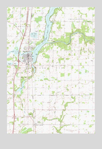
Pine City, MN USGS Topographic Map
Click on map above to begin viewing in our Map Viewer.

This topographic map contains these locations and features:
Feature Name Type Latitude Longitude GNIS ID View Map
Allina Medical Clinic at Pine CityHospitalN45.8264°W92.9664°2069920View Map
Assembly of God ChurchChurchN45.8169°W92.9902°1815009View Map
Bear CreekStreamN45.8411°W92.8772°639759View Map
Birchwood CemeteryCemeteryN45.8247°W92.9780°2069942View Map
Calvary CemeteryCemeteryN45.8236°W92.9773°2069943View Map
Chaleen ParkParkN45.8303°W92.9656°2069939View Map
Chalet CampgroundLocaleN45.7661°W92.9847°2069931View Map
Chengwatana Historical MarkerParkN45.8375°W92.9681°2069925View Map
City of Pine CityCivilN45.8352°W92.9691°665301View Map
City of Rock CreekCivilN45.7604°W92.9088°2396396View Map
Country Oaks Elder Care CenterHospitalN45.8261°W92.9683°2069921View Map
Cross LakeReservoirN45.8394°W92.9377°642488View Map
Czech National CemeteryCemeteryN45.8172°W92.9359°640342View Map
Devils LakeLakeN45.8161°W92.9630°642784View Map
Evergreen Square Shopping MallBuildingN45.8194°W92.9792°2069948View Map
First Presbyterian ChurchChurchN45.8256°W92.9706°2069909View Map
FirstLight Health System Pine City ClinicBuildingN45.8492°W92.9697°2697226View Map
Grace Baptist ChurchChurchN45.8261°W92.9683°2069915View Map
Hilltop CemeteryCemeteryN45.8120°W92.9753°2069916View Map
Hustletown ChurchChurchN45.8602°W92.8819°1815011View Map
Hustletown Community ChurchChurchN45.8261°W92.9683°2069914View Map
Hustletown Union CemeteryCemeteryN45.8594°W92.8825°2069862View Map
Immaculate Conception ChurchChurchN45.8236°W92.9733°2069911View Map
Kick LakeLakeN45.8190°W92.9866°1815010View Map
Lakeside Medical CenterHospitalN45.8244°W92.9647°2069917View Map
Lakeside Urgent Care ClinicHospitalN45.8236°W92.9642°2069918View Map
Meadow Ridge ParkParkN45.8375°W92.9608°2069936View Map
Milburn CemeteryCemeteryN45.8218°W92.8778°647838View Map
Our Redeemer Lutheran ChurchChurchN45.8261°W92.9683°2069913View Map
Pine CityPopulated PlaceN45.8261°W92.9685°649445View Map
Pine CityLocaleN45.8250°W92.9681°2069923View Map
Pine City and Brook Park United Methodist ChurchChurchN45.8244°W92.9725°2069910View Map
Pine City Area ClinicHospitalN45.8244°W92.9653°2069919View Map
Pine City City HallBuildingN45.8264°W92.9689°2069928View Map
Pine City Country ClubLocaleN45.8061°W92.9813°1815008View Map
Pine City Elementary SchoolSchoolN45.8229°W92.9719°2069945View Map
Pine City Evangelical Free ChurchChurchN45.8142°W92.9708°2069912View Map
Pine City Fire DepartmentBuildingN45.8252°W92.9692°2069930View Map
Pine City Historical MarkerParkN45.8375°W92.9681°2069924View Map
Pine City Junior Senior High SchoolSchoolN45.8106°W92.9682°2069946View Map
Pine City LibraryBuildingN45.8264°W92.9689°2069929View Map
Pine City Municipal Airport (historical)AirportN45.8458°W92.9583°660354View Map
Pine City Police DepartmentBuildingN45.8264°W92.9714°2069934View Map
Pine City Post OfficePost OfficeN45.8199°W92.9798°2069922View Map
Pine County CourthouseBuildingN45.8258°W92.9706°2069933View Map
Pine County FairgroundsLocaleN45.8333°W92.9708°2069950View Map
Pine County JailBuildingN45.8529°W92.9716°2758653View Map
Pine County Sheriff's OfficeBuildingN45.8531°W92.9716°2069935View Map
Pine Grove CemeteryCemeteryN45.7910°W92.9288°649453View Map
Pine Medical Ambulance ServiceBuildingN45.8194°W92.9698°2721352View Map
Pine Technical and Community CollegeSchoolN45.8186°W92.9683°2069947View Map
Pine Terrace Mobile Home ParkPopulated PlaceN45.8161°W92.9667°2069949View Map
Riverside ParkParkN45.8319°W92.9692°2069938View Map
Robinson ParkParkN45.8272°W92.9686°2069940View Map
Rock CreekLocaleN45.7603°W92.9622°2069971View Map
Rock CreekPopulated PlaceN45.7575°W92.9624°650185View Map
Rock Creek CemeteryCemeteryN45.7603°W92.9555°1815006View Map
Rock Creek City HallBuildingN45.7575°W92.9622°2069973View Map
Rock Creek ParkParkN45.7661°W92.9877°1815007View Map
Rock Creek Post OfficePost OfficeN45.7575°W92.9622°2069972View Map
Rock LakeLakeN45.7927°W92.9810°650193View Map
Rural School MuseumBuildingN45.8197°W92.9711°2069926View Map
Saint Mary's Catholic SchoolSchoolN45.8236°W92.9743°2069944View Map
School Number 1371SchoolN45.7872°W92.8785°651386View Map
School Number 1562SchoolN45.8597°W92.8788°651398View Map
School Number 1572SchoolN45.8175°W92.9291°651400View Map
School Number 1584SchoolN45.8613°W92.9216°651404View Map
Squaw LakeLakeN45.8122°W92.9606°2069951View Map
Township of Pine CityCivilN45.8111°W92.8929°665302View Map
Township of Rock Creek (historical)CivilN45.7575°W92.9624°2648980View Map
WCMP-AM (Pine City)TowerN45.8194°W92.9960°662965View Map
West Side Park and City BeachParkN45.8250°W92.9800°2069941View Map
Woodpecker Ridge ParkParkN45.8353°W92.9667°2069937View Map
Zion Lutheran ChurchChurchN45.8253°W92.9700°2069908View Map

Note: Coordinates in the location and feature list above are referenced to NAD83 datum.


Copyright (C) 2008-2024 Ryan Niemi / Sunset Dynamics ... All Rights Reserved