TopoQuest Logo
Do you find TopoQuest useful?
Help keep TopoQuest running and adding new maps/features by donating!
Bitcoin:  19c7KJd3qBynnjoSw5npx9KScwjBe4ifkT
Litecoin:  LXs6TkuXGGXo1vDsWCkWVdjQX94eUKd6ui
Home View Maps Find Maps Find Places Resources & Links


Pierson, Florida Topographic Map

USGS Map Title: Pierson, FL
USGS Map MRC: 29081B4
DRG (GeoTIFF) Download: o29081b4.tif


Neighboring USGS Topographic Map Quads:


  Welaka SE, FL  
29081C5
 

  Seville, FL  
29081C4
 

  Codys Corner, FL  
29081C3
 

  Astor, FL  
29081B5
 

  Pierson, FL  
29081B4
 

  Lake Dias, FL  
29081B3
 

  Alexander Springs, FL  
29081A5
 

  Lake Woodruff, FL  
29081A4
 

  De Land, FL  
29081A3


Map MRC Location:

N30°
W82°
N30°
W81°
H8 H7 H6 H5 H4 H3 H2 H1
G8 G7 G6 G5 G4 G3 G2 G1
F8 F7 F6 F5 F4 F3 F2 F1
E8 E7 E6 E5 E4 E3 E2 E1
D8 D7 D6 D5 D4 D3 D2 D1
C8 C7 C6 C5 C4 C3 C2 C1
B8 B7 B6 B5 B4 B3 B2 B1
A8 A7 A6 A5 A4 A3 A2 A1
N29°
W82°
N29°
W81°

Pierson, FL USGS 1:24K Topographic Map Preview:
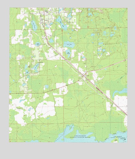
Pierson, FL USGS Topographic Map
Click on map above to begin viewing in our Map Viewer.

This topographic map contains these locations and features:
Feature Name Type Latitude Longitude GNIS ID View Map
Abundant Life FellowshipChurchN29.1897°W81.4269°2391830View Map
Barbersville CemeteryCemeteryN29.1983°W81.4194°2391833View Map
BarbervillePopulated PlaceN29.1872°W81.4209°278099View Map
Barberville Post OfficePost OfficeN29.1859°W81.4228°2391831View Map
Cain LakeLakeN29.2161°W81.4367°279817View Map
Camp Ticochee Girl Scout CampLocaleN29.2086°W81.4006°301663View Map
Communion Christian AssemblyChurchN29.2447°W81.4689°2391872View Map
ConradPopulated PlaceN29.1591°W81.3828°307801View Map
Deep CreekStreamN29.1336°W81.3928°281417View Map
Drudy LakeLakeN29.2165°W81.4698°281772View Map
Ebenezer Lutheran CemeteryCemeteryN29.2360°W81.4622°2581927View Map
Ebenezer Lutheran ChurchChurchN29.2378°W81.4667°2391870View Map
EldridgePopulated PlaceN29.2114°W81.4573°301662View Map
EmporiaPopulated PlaceN29.1991°W81.4681°282210View Map
Emporia Baptist ChurchChurchN29.2015°W81.4679°2391849View Map
First Baptist Church of BarbersvilleChurchN29.1908°W81.4197°2391832View Map
First Baptist Church of PiersonChurchN29.2358°W81.4661°303122View Map
First Church of GodChurchN29.2461°W81.4665°303121View Map
Iglesia Misionaria de PiersonChurchN29.2339°W81.4631°2391915View Map
Lake EmporiaLakeN29.1948°W81.4714°282211View Map
Lake PiersonLakeN29.2335°W81.4736°288799View Map
Lake PurdomLakeN29.2083°W81.4374°289385View Map
Lungren CemeteryCemeteryN29.1686°W81.4766°2581957View Map
McDowell and Black GrantCivilN29.1297°W81.4687°306969View Map
Methodist CemeteryCemeteryN29.2460°W81.4514°2581958View Map
Midway Methodist CemeteryCemeteryN29.1984°W81.4194°2581959View Map
Mount Zion Primitive Baptist CemeteryCemeteryN29.2364°W81.4672°2391869View Map
Oakdale CemeteryCemeteryN29.1961°W81.4781°287996View Map
PiersonPopulated PlaceN29.2394°W81.4656°288798View Map
Pierson CemeteryCemeteryN29.2364°W81.4625°2391914View Map
Pierson Elementary SchoolSchoolN29.2441°W81.4638°299362View Map
Pierson Municipal AirportAirportN29.2480°W81.4618°309827View Map
Pierson Post OfficePost OfficeN29.2406°W81.4669°2391913View Map
Pierson Public LibraryBuildingN29.2403°W81.4669°2391912View Map
Pierson Town HallBuildingN29.2400°W81.4633°2391910View Map
Pierson Town Park Sports ComplexParkN29.2464°W81.4656°2391909View Map
Pierson United Methodist ChurchChurchN29.2397°W81.4647°2391911View Map
Pierson-Seville DivisionCivilN29.2387°W81.4704°1935897View Map
Progress Energy Barbersville SubstationBuildingN29.1797°W81.4103°2391829View Map
Purdom CemeteryCemeteryN29.2041°W81.4334°289384View Map
Saint Peters Catholic Church San Jose MissionChurchN29.2057°W81.4503°2451879View Map
San Jose Catholic MissionChurchN29.2058°W81.4500°2391850View Map
Shaw LakeLakeN29.2353°W81.4442°290944View Map
Stone PondLakeN29.1904°W81.4810°291724View Map
Swanson FieldParkN29.2480°W81.4576°291927View Map
T Dewitt Taylor Middle - High SchoolSchoolN29.2463°W81.4579°292070View Map
The Church of God of ProphecyChurchN29.2453°W81.4683°2391871View Map
The SanctuaryChurchN29.2364°W81.4651°303120View Map
Town of PiersonCivilN29.2401°W81.4559°2407108View Map
Town of Pierson Water TowerTowerN29.2361°W81.4642°2391851View Map
Volusia County Fire Services Station 44 PiersonBuildingN29.2427°W81.4668°2331228View Map
Volusia County Public Library System Pierson Public LibraryBuildingN29.2401°W81.4673°2451871View Map
Volusia County Sheriff's Law Enforcement Services Office District 2A Pierson SubstationBuildingN29.2402°W81.4669°2755978View Map

Note: Coordinates in the location and feature list above are referenced to NAD83 datum.


Copyright (C) 2008-2024 Ryan Niemi / Sunset Dynamics ... All Rights Reserved