TopoQuest Logo
Do you find TopoQuest useful?
Help keep TopoQuest running and adding new maps/features by donating!
Bitcoin:  19c7KJd3qBynnjoSw5npx9KScwjBe4ifkT
Litecoin:  LXs6TkuXGGXo1vDsWCkWVdjQX94eUKd6ui
Home View Maps Find Maps Find Places Resources & Links


Bertrand Creek, Washington Topographic Map

USGS Map Title: Bertrand Creek, WA
USGS Map MRC: 48122H5
DRG (GeoTIFF) Download: o48122h5.tif


Neighboring USGS Topographic Map Quads:


  Blaine, WA  
48122H6
 

  Bertrand Creek, WA  
48122H5
 

  Lynden, WA  
48122H4
 

  Lummi Bay, WA  
48122G6
 

  Ferndale, WA  
48122G5
 

  Bellingham North, WA  
48122G4


Map MRC Location:

N49°
W123°
N49°
W122°
H8 H7 H6 H5 H4 H3 H2 H1
G8 G7 G6 G5 G4 G3 G2 G1
F8 F7 F6 F5 F4 F3 F2 F1
E8 E7 E6 E5 E4 E3 E2 E1
D8 D7 D6 D5 D4 D3 D2 D1
C8 C7 C6 C5 C4 C3 C2 C1
B8 B7 B6 B5 B4 B3 B2 B1
A8 A7 A6 A5 A4 A3 A2 A1
N48°
W123°
N48°
W122°

Bertrand Creek, WA USGS 1:24K Topographic Map Preview:
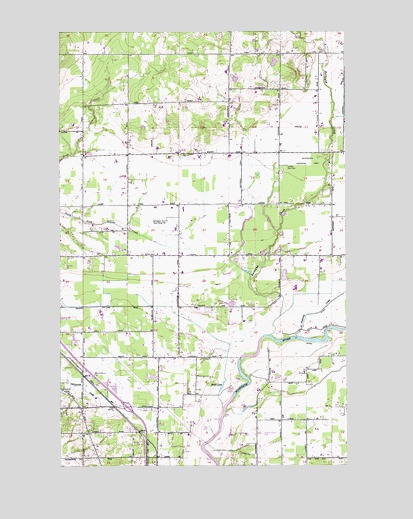
Bertrand Creek, WA USGS Topographic Map
Click on map above to begin viewing in our Map Viewer.

This topographic map contains these locations and features:
Feature Name Type Latitude Longitude GNIS ID View Map
Bellingham Omni Radio Range StationLocaleN48.9454°W122.5791°1503294View Map
Berry AcresLocaleN48.9544°W122.5203°2704170View Map
Berthusen Memorial ParkCemeteryN48.9626°W122.5102°1503326View Map
Bertrand CreekStreamN48.9123°W122.5346°1503327View Map
Blue Moon DairyLocaleN48.9067°W122.5114°2703904View Map
Clark's Berry FarmLocaleN48.9369°W122.5150°2704171View Map
Countryside DairyLocaleN48.9258°W122.5233°2703590View Map
Covenant Grace Reformed ChurchChurchN48.9497°W122.5414°2609640View Map
Delanges DairyLocaleN48.9636°W122.5522°2703947View Map
DeltaPopulated PlaceN48.9809°W122.5249°1514883View Map
Dickerson FarmsLocaleN48.9161°W122.5081°2704389View Map
Duncans Mobile Home ParkPopulated PlaceN48.8782°W122.5825°2607234View Map
Evergreen Community ChurchChurchN48.8909°W122.5838°1504783View Map
Evergreen Mobile Home ParkPopulated PlaceN48.8869°W122.5815°2607235View Map
Fairfield Mobile Home ParkPopulated PlaceN48.8904°W122.6118°2607236View Map
Faith Community Church of LyndenChurchN48.9365°W122.5126°2609641View Map
Fishtrap CreekStreamN48.9118°W122.5229°1504914View Map
Fresh Breeze Organic DairyLocaleN48.9872°W122.5031°2703900View Map
Glendale ChurchChurchN48.9498°W122.5474°1505149View Map
Golden Hills DairyLocaleN48.9808°W122.5139°2703941View Map
Grace Harbor Farms MuseumBuildingN48.9345°W122.6086°2610437View Map
Grandview Industrial ParkLocaleN48.8962°W122.6109°2605335View Map
Hidden Acres DairyLocaleN48.9858°W122.5369°2703540View Map
Hilverda DairyLocaleN48.9486°W122.5839°2703928View Map
Horse Fly AirportAirportN48.8925°W122.5589°2443389View Map
James DairyLocaleN48.9431°W122.5761°2703925View Map
Keefe LakeLakeN48.8979°W122.5555°1505919View Map
Kingdom Hall of Jehovahs WitnessesChurchN48.8978°W122.5842°2609485View Map
Kingdom Hall of Jehovahs WitnessesChurchN48.8991°W122.5299°2609486View Map
Kooiman DairyLocaleN48.9633°W122.5781°2703950View Map
Kortus FarmLocaleN48.9436°W122.5994°2704164View Map
Langley DairyLocaleN48.9831°W122.5003°2703592View Map
Lar A Lin DairyLocaleN48.9517°W122.5814°2704108View Map
Lynden DivisionCivilN48.9591°W122.5090°1939550View Map
Lynden Gun ClubLocaleN48.9612°W122.5266°1533166View Map
M J D FarmsLocaleN48.9478°W122.5714°2704185View Map
M J D RanchLocaleN48.9481°W122.5714°2703545View Map
Meadow Mist AirportAirportN48.9087°W122.5646°1533769View Map
North Whatcom Fire and Rescue Station 68 DeltaBuildingN48.9362°W122.5739°2643641View Map
Northwest Mobile Home ParkPopulated PlaceN48.8840°W122.5390°2607241View Map
Open Door Fellowship ChurchChurchN48.8909°W122.5013°2609648View Map
Pomeroy FarmLocaleN48.9186°W122.6089°2704372View Map
Portal Way Mobile VillagePopulated PlaceN48.8783°W122.5857°2607243View Map
R T J FarmsLocaleN48.9622°W122.6014°2703558View Map
Steensma DairyLocaleN48.9786°W122.5142°2703945View Map
Sunrise ChurchChurchN48.9643°W122.6018°1508834View Map
Sunrise DairyLocaleN48.9631°W122.5858°2703600View Map
Swede Hill FarmLocaleN48.9842°W122.5428°2703544View Map
Tiersma DairyLocaleN48.9661°W122.5833°2703949View Map
Van Beek FarmsLocaleN48.9725°W122.5117°2704159View Map
Van Ingen DairyLocaleN48.9581°W122.5992°2704106View Map
Whatcom County Fire District 7 Station 45 EnterpriseBuildingN48.8920°W122.5828°2643988View Map
Whatcom Medic One Satellite Medic 3 StationBuildingN48.8920°W122.5833°2643627View Map
Willey LakeLakeN48.9215°W122.5520°1509530View Map

Note: Coordinates in the location and feature list above are referenced to NAD83 datum.


Copyright (C) 2008-2024 Ryan Niemi / Sunset Dynamics ... All Rights Reserved