TopoQuest Logo
Do you find TopoQuest useful?
Help keep TopoQuest running and adding new maps/features by donating!
Bitcoin:  19c7KJd3qBynnjoSw5npx9KScwjBe4ifkT
Litecoin:  LXs6TkuXGGXo1vDsWCkWVdjQX94eUKd6ui
Home View Maps Find Maps Find Places Resources & Links


Bertram, Iowa Topographic Map

USGS Map Title: Bertram, IA
USGS Map MRC: 41091H5
DRG (GeoTIFF) Download: o41091h5.tif


Neighboring USGS Topographic Map Quads:


  Cedar Rapids North, IA  
42091A6
 

  Marion, IA  
42091A5
 

  Springville, IA  
42091A4
 

  Cedar Rapids South, IA  
41091H6
 

  Bertram, IA  
41091H5
 

  Mount Vernon, IA  
41091H4
 

  Swisher, IA  
41091G6
 

  Ely, IA  
41091G5
 

  Solon, IA  
41091G4


Map MRC Location:

N42°
W92°
N42°
W91°
H8 H7 H6 H5 H4 H3 H2 H1
G8 G7 G6 G5 G4 G3 G2 G1
F8 F7 F6 F5 F4 F3 F2 F1
E8 E7 E6 E5 E4 E3 E2 E1
D8 D7 D6 D5 D4 D3 D2 D1
C8 C7 C6 C5 C4 C3 C2 C1
B8 B7 B6 B5 B4 B3 B2 B1
A8 A7 A6 A5 A4 A3 A2 A1
N41°
W92°
N41°
W91°

Bertram, IA USGS 1:24K Topographic Map Preview:
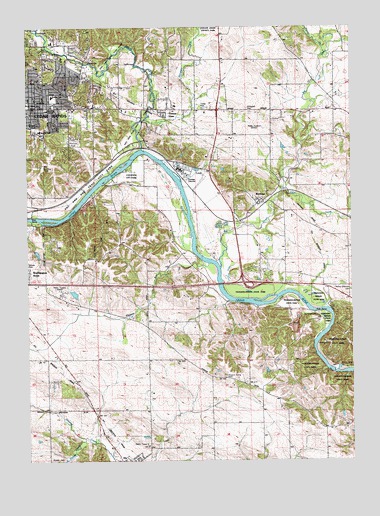
Bertram, IA USGS Topographic Map
Click on map above to begin viewing in our Map Viewer.

This topographic map contains these locations and features:
Feature Name Type Latitude Longitude GNIS ID View Map
Abbe CreekStreamN41.9533°W91.5263°454075View Map
Airport National Public Golf ComplexLocaleN41.8889°W91.6196°2046920View Map
Bena BrookStreamN41.9639°W91.5894°2089085View Map
BertramLocaleN41.9489°W91.5335°2048069View Map
BertramPopulated PlaceN41.9497°W91.5355°454532View Map
Bertram BridgeBridgeN41.9494°W91.5302°2048138View Map
Bertram Post Office (historical)Post OfficeN41.9497°W91.5355°2048068View Map
Bertram United Methodist ChurchChurchN41.9500°W91.5357°2048070View Map
Bever ParkParkN41.9906°W91.6243°454591View Map
Bever ZooLocaleN41.9906°W91.6243°464385View Map
Big CreekStreamN41.9297°W91.5507°454604View Map
Buresh CemeteryCemeteryN41.8757°W91.6171°454990View Map
Calvin-Sinclair Presyterian ChurchChurchN41.9778°W91.6224°2046911View Map
Campbell CemeteryCemeteryN41.9756°W91.5382°455142View Map
Cedar Rapids QuarryMineN41.9156°W91.5231°2611876View Map
Cedar River SandbarBarN41.9010°W91.5050°2741113View Map
Cedar Valley Bible ChurchChurchN41.9956°W91.6155°2046915View Map
Cedar Valley Christian SchoolSchoolN41.9956°W91.6155°2046916View Map
Cheyenne City ParkParkN41.9583°W91.5835°465935View Map
City of BertramCivilN41.9511°W91.5376°2394152View Map
City of ElyCivilN41.8753°W91.5850°2394683View Map
Dumke ParkParkN41.9600°W91.6188°465937View Map
Erskine Elementary SchoolSchoolN41.9802°W91.6154°456389View Map
Hennessey QuarryMineN41.9460°W91.6080°2740245View Map
Hitters ParkParkN41.9758°W91.5530°2046919View Map
Indian CreekStreamN41.9653°W91.5807°457793View Map
Indian Creek BridgeBridgeN41.9875°W91.5785°2048135View Map
Indian Creek Bridge TwoBridgeN41.9667°W91.5807°2048141View Map
Indian Creek Nature CenterLocaleN41.9661°W91.5793°2046917View Map
Indian Creek ParkParkN41.9806°W91.5752°2046918View Map
Jehovahs Witnesses Pioneer Avenue Congregation Kingdom HallChurchN41.9750°W91.5418°2046731View Map
KCRG-AM (Cedar Rapids)TowerN41.9725°W91.5346°467007View Map
KHAK-AM (Cedar Rapids)TowerN41.9244°W91.6155°467004View Map
KHAK-FM (Cedar Rapids)TowerN41.9244°W91.6155°467090View Map
KHAK-FM (Cedar Rapids)TowerN41.9389°W91.6016°463719View Map
Living Water United Methodist ChurchChurchN41.9778°W91.5691°2046723View Map
Martin CreekStreamN41.9914°W91.5102°458832View Map
Mercy Care Vernon VillageHospitalN41.9764°W91.6127°2046810View Map
Monroe Elementary SchoolSchoolN41.9702°W91.6203°459186View Map
Monroe ParkParkN41.9708°W91.6221°459183View Map
Moore - Skillman CemeteryCemeteryN41.9240°W91.5010°459213View Map
Navajo ParkParkN41.9311°W91.6243°465934View Map
OtisPopulated PlaceN41.9514°W91.6232°464186View Map
Palisades-Kepler State ParkParkN41.9075°W91.5063°459997View Map
Pioneer ParkParkN41.9667°W91.6021°465938View Map
Pleasant RunStreamN41.9314°W91.5566°460295View Map
Rogers Grove CemeteryCemeteryN41.8992°W91.5491°460766View Map
Sac and Fox Trail City ParkParkN41.9539°W91.6016°465936View Map
Saint George Orthodox ChurchChurchN41.9953°W91.6141°2046912View Map
Saint John the Baptist Orthodox ChurchChurchN41.9944°W91.6141°2046913View Map
Saint Stephen Lutheran ChurchChurchN41.9800°W91.6146°2046910View Map
Seventh Day Church of GodChurchN41.9692°W91.6218°2046737View Map
South Hoosier CreekStreamN41.8817°W91.6041°461788View Map
Squaw CreekStreamN41.9733°W91.5788°461934View Map
The Church of Jesus Christ of Latter Day SaintsChurchN41.9861°W91.6049°2046914View Map
Township of BertramCivilN41.9554°W91.5310°467449View Map
Township of PutnamCivilN41.8978°W91.5503°468583View Map
Valley View Baptist ChurchChurchN41.9761°W91.5838°2046730View Map
Vernon ViewPopulated PlaceN41.9756°W91.5730°462558View Map
West Bertram Fire DepartmentBuildingN41.9699°W91.5768°2577385View Map
Williams CemeteryCemeteryN41.9250°W91.6057°2048101View Map
Winnebago ParkParkN41.9439°W91.6238°2046908View Map

Note: Coordinates in the location and feature list above are referenced to NAD83 datum.


Copyright (C) 2008-2024 Ryan Niemi / Sunset Dynamics ... All Rights Reserved