TopoQuest Logo
Do you find TopoQuest useful?
Help keep TopoQuest running and adding new maps/features by donating!
Bitcoin:  19c7KJd3qBynnjoSw5npx9KScwjBe4ifkT
Litecoin:  LXs6TkuXGGXo1vDsWCkWVdjQX94eUKd6ui
Home View Maps Find Maps Find Places Resources & Links


Peterson, West Virginia Topographic Map

USGS Map Title: Peterson, WV
USGS Map MRC: 38080H5
DRG (GeoTIFF) Download: o38080h5.tif


Neighboring USGS Topographic Map Quads:


  Vadis, WV  
39080A6
 

  Camden, WV  
39080A5
 

  Weston, WV  
39080A4
 

  Gilmer, WV  
38080H6
 

  Peterson, WV  
38080H5
 

  Roanoke, WV  
38080H4
 

  Burnsville, WV  
38080G6
 

  Orlando, WV  
38080G5
 

  Walkersville, WV  
38080G4


Map MRC Location:

N39°
W81°
N39°
W80°
H8 H7 H6 H5 H4 H3 H2 H1
G8 G7 G6 G5 G4 G3 G2 G1
F8 F7 F6 F5 F4 F3 F2 F1
E8 E7 E6 E5 E4 E3 E2 E1
D8 D7 D6 D5 D4 D3 D2 D1
C8 C7 C6 C5 C4 C3 C2 C1
B8 B7 B6 B5 B4 B3 B2 B1
A8 A7 A6 A5 A4 A3 A2 A1
N38°
W81°
N38°
W80°

Peterson, WV USGS 1:24K Topographic Map Preview:
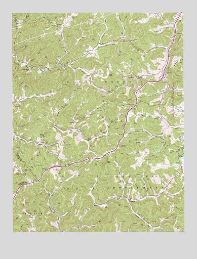
Peterson, WV USGS Topographic Map
Click on map above to begin viewing in our Map Viewer.

This topographic map contains these locations and features:
Feature Name Type Latitude Longitude GNIS ID View Map
ArnoldPopulated PlaceN38.9137°W80.5031°1549569View Map
AspinallPopulated PlaceN38.9262°W80.6043°1549572View Map
Aspinall RunStreamN38.9854°W80.5448°1535065View Map
Bealls MillsPopulated PlaceN38.9684°W80.6112°1549580View Map
Bear RunStreamN38.8945°W80.5443°1535389View Map
BennettPopulated PlaceN38.8912°W80.5654°1549589View Map
Bens RunStreamN38.9259°W80.6040°1535648View Map
Brush RunStreamN38.9354°W80.5945°1536471View Map
Calf RunStreamN38.9290°W80.6187°1536861View Map
Clapboard RunStreamN38.8984°W80.5151°1537345View Map
Coal RunStreamN38.9712°W80.6143°1537467View Map
Courthouse-Collins Settlement DistrictCivilN38.9211°W80.5113°1928199View Map
Crooked ForkStreamN38.9695°W80.5829°1537837View Map
Crooked RunStreamN38.8787°W80.5740°1537848View Map
FinsterPopulated PlaceN38.9382°W80.5795°1554454View Map
Finster ChapelChurchN38.9304°W80.6023°1538971View Map
Flag KnobSummitN38.9145°W80.5568°1554467View Map
Flusher School (historical)SchoolN38.9829°W80.5556°1689944View Map
Ford RunStreamN38.8945°W80.5276°1539119View Map
GilloolyPopulated PlaceN38.9776°W80.5701°1554555View Map
Goosepen RunStreamN38.9268°W80.5695°1539531View Map
Goosepen School (historical)SchoolN38.9334°W80.5854°1689945View Map
Grasslick RunStreamN38.8834°W80.5906°1539622View Map
Heavner SpringSpringN38.9790°W80.5318°1677946View Map
Indian RunStreamN38.9215°W80.5018°1540697View Map
Interchange 91CrossingN38.9634°W80.5151°1728587View Map
Jennings RunStreamN38.9926°W80.5076°1540866View Map
Laurel RunStreamN38.9940°W80.6195°1541543View Map
Lewis CountyCivilN38.9959°W80.5022°1550027View Map
Loveberry RunStreamN38.9715°W80.5909°1542485View Map
Middle Fork Canoe RunStreamN38.9298°W80.5156°1543176View Map
Middle RunStreamN38.9295°W80.5218°1543217View Map
Nearway RunStreamN38.9965°W80.6148°1544071View Map
Oak Grove ChurchChurchN38.9634°W80.5331°1544288View Map
Oak Grove School (historical)SchoolN38.9640°W80.5423°1689946View Map
PetersonPopulated PlaceN38.8929°W80.5395°1549872View Map
Pine KnobSummitN38.9645°W80.5520°1544895View Map
Pine RunStreamN38.9315°W80.6237°1544900View Map
Pine Run School (historical)SchoolN38.9326°W80.6237°1689948View Map
Polly RunStreamN38.9248°W80.6076°1545121View Map
Poplarlick RunStreamN38.9929°W80.5101°1545153View Map
Raccoon RunStreamN38.9995°W80.5190°1545367View Map
Redlick RunStreamN38.8926°W80.5412°1545476View Map
Redlick School (historical)SchoolN38.8770°W80.5229°1689949View Map
Rhodes CemeteryCemeteryN38.9459°W80.5023°2586255View Map
Right Fork Canoe RunStreamN38.9348°W80.5098°1545622View Map
Roanoke Elementary SchoolSchoolN38.9218°W80.5098°1728660View Map
Rock RunStreamN38.9756°W80.6223°1545921View Map
Rush KnobSummitN38.9237°W80.5454°1555541View Map
Saint Bernard CemeteryCemeteryN38.9926°W80.5926°1728664View Map
Saint Bernards ChurchChurchN38.9929°W80.5926°1546223View Map
Saint Bernards School (historical)SchoolN38.9926°W80.5929°1689950View Map
Saint Bridgets ChurchChurchN38.9318°W80.5573°1546225View Map
Second Big RunStreamN38.8909°W80.5640°1546540View Map
Sleepcamp RunStreamN38.9337°W80.5801°1546932View Map
Sugarcamp RunStreamN38.9243°W80.6004°1547684View Map
Threelick School (historical)SchoolN38.9082°W80.5806°1689951View Map
Tully RidgeRidgeN38.9132°W80.5954°1548315View Map
Ward School (historical)SchoolN38.9956°W80.5126°1689953View Map
White Doll School (historical)SchoolN38.9359°W80.5109°1689954View Map
Wolfpen RunStreamN38.9809°W80.5615°1549357View Map
Wyant School (historical)SchoolN38.9518°W80.6245°1689955View Map

Note: Coordinates in the location and feature list above are referenced to NAD83 datum.


Copyright (C) 2008-2024 Ryan Niemi / Sunset Dynamics ... All Rights Reserved