TopoQuest Logo
Do you find TopoQuest useful?
Help keep TopoQuest running and adding new maps/features by donating!
Bitcoin:  19c7KJd3qBynnjoSw5npx9KScwjBe4ifkT
Litecoin:  LXs6TkuXGGXo1vDsWCkWVdjQX94eUKd6ui
Home View Maps Find Maps Find Places Resources & Links


Perryville East, Missouri Topographic Map

USGS Map Title: Perryville East, MO
USGS Map MRC: 37089F7
DRG (GeoTIFF) Download: o37089f7.tif


Neighboring USGS Topographic Map Quads:


  Lithium, MO  
37089G8
 

  Belgique, MO  
37089G7
 

  Rockwood, IL  
37089G6
 

  Perryville West, MO  
37089F8
 

  Perryville East, MO  
37089F7
 

  Crosstown, MO  
37089F6
 

  Sedgewickville, MO  
37089E8
 

  Friedheim, MO  
37089E7
 

  Oak Ridge, MO  
37089E6


Map MRC Location:

N38°
W90°
N38°
W89°
H8 H7 H6 H5 H4 H3 H2 H1
G8 G7 G6 G5 G4 G3 G2 G1
F8 F7 F6 F5 F4 F3 F2 F1
E8 E7 E6 E5 E4 E3 E2 E1
D8 D7 D6 D5 D4 D3 D2 D1
C8 C7 C6 C5 C4 C3 C2 C1
B8 B7 B6 B5 B4 B3 B2 B1
A8 A7 A6 A5 A4 A3 A2 A1
N37°
W90°
N37°
W89°

Perryville East, MO USGS 1:24K Topographic Map Preview:
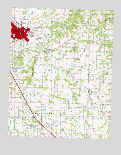
Perryville East, MO USGS Topographic Map
Click on map above to begin viewing in our Map Viewer.

This topographic map contains these locations and features:
Feature Name Type Latitude Longitude GNIS ID View Map
Abernathy School (historical)SchoolN37.6659°W89.7857°713126View Map
Baptist Shed CemeteryCemeteryN37.7087°W89.7576°743253View Map
Bedwell HollowValleyN37.6564°W89.7848°738551View Map
Calvary ChurchPopulated PlaceN37.6695°W89.7723°741393View Map
Cashion SchoolSchoolN37.6689°W89.8440°715473View Map
Dry Run BranchStreamN37.7278°W89.8207°738553View Map
Duggins Mill (historical)LocaleN37.7484°W89.7996°736425View Map
Duggins School (historical)SchoolN37.7414°W89.7846°717163View Map
FriedenbergPopulated PlaceN37.7009°W89.7940°740859View Map
Friedenberg CemeteryCemeteryN37.7093°W89.8291°743252View Map
Hart CemeteryCemeteryN37.6331°W89.8076°743246View Map
Home CemeteryCemeteryN37.7334°W89.8679°743250View Map
Horn CemeteryCemeteryN37.7287°W89.7782°743255View Map
Immanuel CemeteryCemeteryN37.7284°W89.8462°743251View Map
Killian School (historical)SchoolN37.7070°W89.8398°720580View Map
LongtownPopulated PlaceN37.6698°W89.7737°1699793View Map
Perry CountyCivilN37.7071°W89.8244°758533View Map
Perry County Fire Protection Association Station 1BuildingN37.7255°W89.8671°2620870View Map
Perry County Memorial HospitalHospitalN37.7321°W89.8654°2655069View Map
Perry County Sheriff's OfficeBuildingN37.7253°W89.8505°2752256View Map
Perry Plaza Shopping CenterLocaleN37.7348°W89.8693°742504View Map
PerryvillePopulated PlaceN37.7242°W89.8612°724239View Map
Perryville Fire Department Station 1BuildingN37.7256°W89.8663°2621179View Map
Perryville Fire Department Station 2BuildingN37.7269°W89.8645°2621183View Map
Perryville Police DepartmentBuildingN37.7266°W89.8641°2752562View Map
Perryville Post OfficePost OfficeN37.7260°W89.8616°2783138View Map
Rock Springs SchoolSchoolN37.7059°W89.7871°725472View Map
Saint Boniface CemeteryCemeteryN37.7234°W89.8715°743249View Map
Saint Boniface Church (historical)ChurchN37.7239°W89.8721°736424View Map
Saint Vincent High SchoolSchoolN37.7234°W89.8748°743248View Map
Schawanes Springs BranchStreamN37.7095°W89.8312°726096View Map
Stump CemeteryCemeteryN37.7225°W89.7662°743254View Map
Town of LongtownCivilN37.6703°W89.7741°2396724View Map
Township of CentralCivilN37.7309°W89.8625°767153View Map
Township of Cinque HommesCivilN37.6431°W89.8614°767154View Map
Willow PondLakeN37.7281°W89.8582°738552View Map
York ChapelChurchN37.6789°W89.7909°729203View Map
Zion CemeteryCemeteryN37.6721°W89.7768°743247View Map

Note: Coordinates in the location and feature list above are referenced to NAD83 datum.


Copyright (C) 2008-2024 Ryan Niemi / Sunset Dynamics ... All Rights Reserved