TopoQuest Logo
Do you find TopoQuest useful?
Help keep TopoQuest running and adding new maps/features by donating!
Bitcoin:  19c7KJd3qBynnjoSw5npx9KScwjBe4ifkT
Litecoin:  LXs6TkuXGGXo1vDsWCkWVdjQX94eUKd6ui
Home View Maps Find Maps Find Places Resources & Links


Perrysville, Indiana Topographic Map

USGS Map Title: Perrysville, IN
USGS Map MRC: 40087A4
DRG (GeoTIFF) Download: o40087a4.tif


Neighboring USGS Topographic Map Quads:


  Danville NE, IL  
40087B5
 

  Covington, IN  
40087B4
 

  Stone Bluff, IN  
40087B3
 

  Danville SE, IL  
40087A5
 

  Perrysville, IN  
40087A4
 

  Veedersburg, IN  
40087A3
 

  Humrick, IL  
39087H5
 

  Newport, IN  
39087H4
 

  Kingman, IN  
39087H3


Map MRC Location:

N41°
W88°
N41°
W87°
H8 H7 H6 H5 H4 H3 H2 H1
G8 G7 G6 G5 G4 G3 G2 G1
F8 F7 F6 F5 F4 F3 F2 F1
E8 E7 E6 E5 E4 E3 E2 E1
D8 D7 D6 D5 D4 D3 D2 D1
C8 C7 C6 C5 C4 C3 C2 C1
B8 B7 B6 B5 B4 B3 B2 B1
A8 A7 A6 A5 A4 A3 A2 A1
N40°
W88°
N40°
W87°

Perrysville, IN USGS 1:24K Topographic Map Preview:
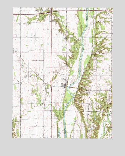
Perrysville, IN USGS Topographic Map
Click on map above to begin viewing in our Map Viewer.

This topographic map contains these locations and features:
Feature Name Type Latitude Longitude GNIS ID View Map
Ater CemeteryCemeteryN40.0631°W87.4853°430319View Map
Chenoweth CemeteryCemeteryN40.0423°W87.4379°432441View Map
Coal CreekPopulated PlaceN40.0364°W87.3806°432703View Map
Coffing Brothers DamDamN40.0084°W87.3983°448639View Map
Coffing Brothers LakeReservoirN40.0096°W87.4007°448640View Map
Collett PondLakeN40.0045°W87.4419°432782View Map
Flat IronPopulated PlaceN40.0534°W87.4900°434564View Map
GessiePopulated PlaceN40.0825°W87.4997°435046View Map
Highland Airport (historical)AirportN40.0570°W87.4856°449303View Map
Highland Elementary SchoolSchoolN40.0486°W87.4353°447551View Map
Hopewell ChurchChurchN40.1092°W87.4908°436460View Map
Jericho CreekStreamN40.0328°W87.4522°436995View Map
Jordan CreekStreamN40.0175°W87.4361°437116View Map
Lower Mound CemeteryCemeteryN40.1108°W87.4322°438370View Map
Mount Carmel ChurchChurchN40.0459°W87.4033°439552View Map
North Fork Spring CreekStreamN40.1139°W87.4656°440259View Map
PerrysvillePopulated PlaceN40.0514°W87.4333°441034View Map
Perrysville Volunteer Fire DepartmentBuildingN40.0516°W87.4335°2625856View Map
Prairie CreekStreamN40.0159°W87.3792°441545View Map
Smith CemeteryCemeteryN40.0262°W87.4514°443671View Map
Spring CreekStreamN40.0884°W87.4128°418929View Map
Stringtown ChurchChurchN40.0386°W87.3808°444273View Map
Town of PerrysvilleCivilN40.0532°W87.4360°2396854View Map
Township of HighlandCivilN40.0710°W87.4779°453413View Map
Tree SpringPopulated PlaceN40.0967°W87.4331°444868View Map
Wabash ChapelChurchN40.0828°W87.3764°445329View Map
West Liberty ChurchChurchN40.0256°W87.4050°445784View Map

Note: Coordinates in the location and feature list above are referenced to NAD83 datum.


Copyright (C) 2008-2024 Ryan Niemi / Sunset Dynamics ... All Rights Reserved