TopoQuest Logo
Do you find TopoQuest useful?
Help keep TopoQuest running and adding new maps/features by donating!
Bitcoin:  19c7KJd3qBynnjoSw5npx9KScwjBe4ifkT
Litecoin:  LXs6TkuXGGXo1vDsWCkWVdjQX94eUKd6ui
Home View Maps Find Maps Find Places Resources & Links


Perkins, Oklahoma Topographic Map

USGS Map Title: Perkins, OK
USGS Map MRC: 35097H1
DRG (GeoTIFF) Download: o35097h1.tif


Neighboring USGS Topographic Map Quads:


  Stillwater SW, OK  
36097A2
 

  Stillwater South, OK  
36097A1
 

  Ripley, OK  
36096A8
 

  Coyle, OK  
35097H2
 

  Perkins, OK  
35097H1
 

  Tryon North, OK  
35096H8
 

  Meridian, OK  
35097G2
 

  Carney, OK  
35097G1
 

  Tryon South, OK  
35096G8


Map MRC Location:

N36°
W98°
N36°
W97°
H8 H7 H6 H5 H4 H3 H2 H1
G8 G7 G6 G5 G4 G3 G2 G1
F8 F7 F6 F5 F4 F3 F2 F1
E8 E7 E6 E5 E4 E3 E2 E1
D8 D7 D6 D5 D4 D3 D2 D1
C8 C7 C6 C5 C4 C3 C2 C1
B8 B7 B6 B5 B4 B3 B2 B1
A8 A7 A6 A5 A4 A3 A2 A1
N35°
W98°
N35°
W97°

Perkins, OK USGS 1:24K Topographic Map Preview:
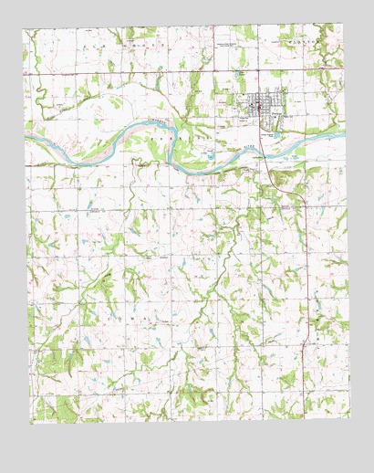
Perkins, OK USGS Topographic Map
Click on map above to begin viewing in our Map Viewer.

This topographic map contains these locations and features:
Feature Name Type Latitude Longitude GNIS ID View Map
Bible Evanglistic TempleChurchN35.9828°W97.0184°1809782View Map
Brandon CemeteryCemeteryN35.8987°W97.0575°1090455View Map
City of PerkinsCivilN35.9781°W97.0299°2411402View Map
Corduroy CreekStreamN35.9567°W97.0692°1091686View Map
Iowa Chapel CemeteryCemeteryN35.8981°W97.1242°1094114View Map
Iowa Tribal Police DepartmentBuildingN35.9279°W97.0254°2757918View Map
Iowa Tribal Volunteer Fire DepartmentBuildingN35.9422°W97.0299°2657526View Map
Knipe CemeteryCemeteryN35.9703°W97.0417°1094421View Map
Oklahoma State University Experimental FarmSchoolN35.9923°W97.0461°1096216View Map
Oknoname 08117 DamDamN35.9384°W97.0003°1753035View Map
Olivet CemeteryCemeteryN35.9428°W97.1055°2705515View Map
Olivet ChurchChurchN35.9426°W97.1053°1096263View Map
PerkinsPopulated PlaceN35.9739°W97.0336°1096551View Map
Perkins - Tryon Elementary SchoolSchoolN35.9773°W97.0202°1803469View Map
Perkins - Tryon High SchoolSchoolN35.9861°W97.0235°1790431View Map
Perkins - Tryon Intermediate Elementary SchoolSchoolN35.9739°W97.0359°2712857View Map
Perkins - Tryon Junior High SchoolSchoolN35.9745°W97.0369°1790432View Map
Perkins CemeteryCemeteryN35.9722°W97.0417°2705517View Map
Perkins Fire DepartmentBuildingN35.9744°W97.0341°2656944View Map
Perkins Police DepartmentBuildingN35.9745°W97.0335°2757506View Map
Township of IowaCivilN35.8862°W97.0920°1824904View Map
Township of PerkinsCivilN35.9584°W97.0753°1824863View Map
Twin LakesReservoirN35.9841°W97.0424°1099108View Map
VincoPopulated PlaceN35.9537°W97.0375°1099267View Map
Walnut CreekStreamN35.9567°W97.1048°1099324View Map
Wild Horse CreekStreamN35.9684°W97.0845°1099760View Map

Note: Coordinates in the location and feature list above are referenced to NAD83 datum.


Copyright (C) 2008-2024 Ryan Niemi / Sunset Dynamics ... All Rights Reserved