TopoQuest Logo
Do you find TopoQuest useful?
Help keep TopoQuest running and adding new maps/features by donating!
Bitcoin:  19c7KJd3qBynnjoSw5npx9KScwjBe4ifkT
Litecoin:  LXs6TkuXGGXo1vDsWCkWVdjQX94eUKd6ui
Home View Maps Find Maps Find Places Resources & Links


Peniel, West Virginia Topographic Map

USGS Map Title: Peniel, WV
USGS Map MRC: 38081G4
DRG (GeoTIFF) Download: o38081g4.tif


Neighboring USGS Topographic Map Quads:


  Liverpool, WV  
38081H5
 

  Reedy, WV  
38081H4
 

  Burning Springs, WV  
38081H3
 

  Gay, WV  
38081G5
 

  Peniel, WV  
38081G4
 

  Spencer, WV  
38081G3
 

  Kentuck, WV  
38081F5
 

  Walton, WV  
38081F4
 

  Looneyville, WV  
38081F3


Map MRC Location:

N39°
W82°
N39°
W81°
H8 H7 H6 H5 H4 H3 H2 H1
G8 G7 G6 G5 G4 G3 G2 G1
F8 F7 F6 F5 F4 F3 F2 F1
E8 E7 E6 E5 E4 E3 E2 E1
D8 D7 D6 D5 D4 D3 D2 D1
C8 C7 C6 C5 C4 C3 C2 C1
B8 B7 B6 B5 B4 B3 B2 B1
A8 A7 A6 A5 A4 A3 A2 A1
N38°
W82°
N38°
W81°

Peniel, WV USGS 1:24K Topographic Map Preview:
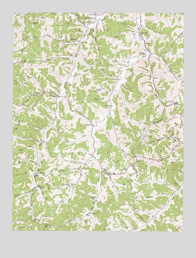
Peniel, WV USGS Topographic Map
Click on map above to begin viewing in our Map Viewer.

This topographic map contains these locations and features:
Feature Name Type Latitude Longitude GNIS ID View Map
BarrsPopulated PlaceN38.8231°W81.3807°1535274View Map
Batten RunStreamN38.7581°W81.3957°1535308View Map
Bear RunStreamN38.8506°W81.4010°1535388View Map
Beckley CemeteryCemeteryN38.7942°W81.4382°1535463View Map
Beech Grove United Methodist ChurchChurchN38.8629°W81.4068°1535539View Map
Beech RunStreamN38.8662°W81.4454°1535551View Map
Bethel United Methodist ChurchChurchN38.8245°W81.3826°1535702View Map
BillingsPopulated PlaceN38.8573°W81.4037°1553904View Map
Billings School (historical)SchoolN38.8512°W81.4029°1535997View Map
Board CemeteryCemeteryN38.7892°W81.4796°1536157View Map
Boggs School (historical)SchoolN38.8331°W81.4254°1740855View Map
Carpenter CemeteryCemeteryN38.7798°W81.4168°1537050View Map
Cherry Valley ChurchChurchN38.7754°W81.4576°1740867View Map
Chrislip CemeteryCemeteryN38.7937°W81.4418°1537326View Map
ClarencePopulated PlaceN38.7756°W81.4812°1549628View Map
Clarence ChurchChurchN38.7815°W81.4843°1537347View Map
Colt RidgeRidgeN38.8104°W81.3990°1537538View Map
Colt RunStreamN38.8323°W81.4235°1537539View Map
Cox RunStreamN38.8356°W81.4223°1537761View Map
Curtis School (historical)SchoolN38.7926°W81.4412°1740877View Map
DepuePopulated PlaceN38.8381°W81.3971°1554294View Map
Dicks RunStreamN38.8623°W81.4098°1538184View Map
District ICivilN38.7930°W81.4529°1953485View Map
Dutch RidgeRidgeN38.8737°W81.4610°1538466View Map
Fairview School (historical)SchoolN38.8118°W81.3951°1538839View Map
Galahoe CemeteryCemeteryN38.7806°W81.4323°1539309View Map
Gandee RunStreamN38.8054°W81.4404°1539322View Map
Green Valley ChurchChurchN38.8590°W81.4532°1539692View Map
Johnson RunStreamN38.8684°W81.4410°1540990View Map
Lake Trotter DamDamN38.7801°W81.3798°1559297View Map
Laurel Hill School (historical)SchoolN38.7826°W81.4282°1541474View Map
Leaning OakPopulated PlaceN38.7737°W81.3790°1740929View Map
Leaning Oak School (historical)SchoolN38.7743°W81.3798°1740930View Map
Lion ForkStreamN38.7731°W81.3793°1542007View Map
Long RunStreamN38.8495°W81.4554°1542401View Map
McCauley RunStreamN38.8293°W81.4254°1542926View Map
McCoy CemeteryCemeteryN38.7837°W81.4523°1542964View Map
McCumber RunStreamN38.7709°W81.3823°1542977View Map
Miller CemeteryCemeteryN38.7801°W81.4221°1543372View Map
Miller CemeteryCemeteryN38.7912°W81.4496°1543373View Map
Miller RunStreamN38.8670°W81.4068°1543394View Map
Morning StarPopulated PlaceN38.7748°W81.4554°1740951View Map
Morning Star School (historical)SchoolN38.7754°W81.4579°1543561View Map
Mount OlivePopulated PlaceN38.8218°W81.4273°1740953View Map
Mount Olive ChurchChurchN38.8218°W81.4279°1543708View Map
Mount RunStreamN38.8251°W81.4276°1543754View Map
Mount Union ChurchChurchN38.7684°W81.4410°1543778View Map
Mount Zion CemeteryCemeteryN38.8126°W81.4962°1946425View Map
Mount Zion Community ChurchChurchN38.8123°W81.4968°1543826View Map
Nebo School (historical)SchoolN38.8362°W81.3751°1740955View Map
Noble ChurchChurchN38.8531°W81.4932°1544185View Map
North Star School (historical)SchoolN38.8104°W81.4718°1740958View Map
Panther KnobSummitN38.8690°W81.4851°1555302View Map
PenielPopulated PlaceN38.8273°W81.4676°1549871View Map
Peniel Community ChurchChurchN38.8270°W81.4660°1740970View Map
Peniel RunStreamN38.8262°W81.4657°1544700View Map
Peniel School (historical)SchoolN38.8345°W81.4618°1544701View Map
ReedyvillePopulated PlaceN38.8104°W81.4410°1549894View Map
Riddle HollowValleyN38.7973°W81.4829°1545570View Map
Roane County Country Club Golf CourseLocaleN38.8405°W81.4196°2634168View Map
Roberts CemeteryCemeteryN38.7770°W81.4568°1545843View Map
Rush RunStreamN38.8509°W81.4001°1546168View Map
Saltblock RunStreamN38.8706°W81.4393°1546311View Map
Scaffold RunStreamN38.7998°W81.3776°1546476View Map
Staats RunStreamN38.8584°W81.4512°1547305View Map
Stoney Point United Methodist ChurchChurchN38.8731°W81.4382°1547496View Map
Stony Point School (historical)SchoolN38.8715°W81.4368°1741012View Map
Stover ForkStreamN38.7915°W81.4398°1547535View Map
Sunnybank School (historical)SchoolN38.7509°W81.4123°1741016View Map
Tanner Run School (historical)SchoolN38.7915°W81.3921°1741019View Map
Triump ChurchChurchN38.7851°W81.4165°1548282View Map
Tucker RunStreamN38.8193°W81.4285°1548305View Map
Union School (historical)SchoolN38.7848°W81.4818°1548491View Map
Valley Forge School (historical)SchoolN38.8576°W81.4618°1741028View Map
VandaliaPopulated PlaceN38.7595°W81.4443°1549970View Map
Weaver CemeteryCemeteryN38.7901°W81.4093°1548858View Map
Wilson CemeteryCemeteryN38.7551°W81.4001°1549211View Map

Note: Coordinates in the location and feature list above are referenced to NAD83 datum.


Copyright (C) 2008-2024 Ryan Niemi / Sunset Dynamics ... All Rights Reserved