TopoQuest Logo
Do you find TopoQuest useful?
Help keep TopoQuest running and adding new maps/features by donating!
Bitcoin:  19c7KJd3qBynnjoSw5npx9KScwjBe4ifkT
Litecoin:  LXs6TkuXGGXo1vDsWCkWVdjQX94eUKd6ui
Home View Maps Find Maps Find Places Resources & Links


Pembina, North Dakota Topographic Map

USGS Map Title: Pembina, ND
USGS Map MRC: 48097H2
DRG (GeoTIFF) Download: o48097h2.tif


Neighboring USGS Topographic Map Quads:


  Bathgate NE, ND  
48097H3
 

  Pembina, ND  
48097H2
 

  Humboldt, MN  
48097H1
 

  Bathgate SE, ND  
48097G3
 

  Joliette, ND  
48097G2
 

  Hill Siding, MN  
48097G1


Map MRC Location:

N49°
W98°
N49°
W97°
H8 H7 H6 H5 H4 H3 H2 H1
G8 G7 G6 G5 G4 G3 G2 G1
F8 F7 F6 F5 F4 F3 F2 F1
E8 E7 E6 E5 E4 E3 E2 E1
D8 D7 D6 D5 D4 D3 D2 D1
C8 C7 C6 C5 C4 C3 C2 C1
B8 B7 B6 B5 B4 B3 B2 B1
A8 A7 A6 A5 A4 A3 A2 A1
N48°
W98°
N48°
W97°

Pembina, ND USGS 1:24K Topographic Map Preview:
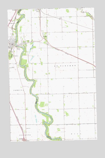
Pembina, ND USGS Topographic Map
Click on map above to begin viewing in our Map Viewer.

This topographic map contains these locations and features:
Feature Name Type Latitude Longitude GNIS ID View Map
Christ Episcopal ChurchChurchN48.9685°W97.2315°2576220View Map
City of PembinaCivilN48.9665°W97.2474°1036216View Map
City of Saint VincentCivilN48.9693°W97.2263°2396522View Map
County Ditch Number TwentyeightCanalN48.9194°W97.1598°641904View Map
County Ditch Number TwentynineCanalN48.8905°W97.1281°641917View Map
Huron City (historical)Populated PlaceN48.9972°W97.2337°1034511View Map
Joe River CemeteryCemeteryN48.9921°W97.1387°645657View Map
Joe River School (historical)SchoolN48.9844°W97.1278°2120216View Map
Kittson Central-Saint Vincent Elementary SchoolSchoolN48.9689°W97.2261°2105848View Map
Lake StellaLakeN48.9637°W97.2169°652615View Map
Larry J Wilwant Community CenterBuildingN48.9678°W97.2447°2746053View Map
McArthurPopulated PlaceN48.8764°W97.2278°1033779View Map
McArthur CemeteryCemeteryN48.8874°W97.2284°1028913View Map
McArthur InterchangeCrossingN48.8764°W97.2303°1030131View Map
Metis CemeteryCemeteryN48.9878°W97.2447°2782400View Map
North Border-Pembina Public SchoolSchoolN48.9675°W97.2488°2748357View Map
North Hill School (historical)SchoolN48.8758°W97.1500°2120218View Map
NoyesLocaleN48.9975°W97.2042°2105645View Map
NoyesPopulated PlaceN48.9975°W97.2045°648769View Map
Noyes Post OfficePost OfficeN48.9975°W97.2042°2105641View Map
PembinaPopulated PlaceN48.9664°W97.2437°1030666View Map
Pembina (North Border) School and Public LibraryBuildingN48.9675°W97.2486°2745709View Map
Pembina Ambulance ServiceBuildingN48.9677°W97.2447°2658826View Map
Pembina City DamDamN48.9567°W97.2370°1033167View Map
Pembina City HallBuildingN48.9678°W97.2447°2745175View Map
Pembina Fire DepartmentBuildingN48.9679°W97.2443°2637518View Map
Pembina Lutheran Cemetery - Lutheran CemeteryCemeteryN48.9566°W97.2418°1030046View Map
Pembina Municipal AirportAirportN48.9480°W97.2402°1033541View Map
Pembina RiverStreamN48.9664°W97.2392°1035889View Map
Pembina State ParkParkN48.9644°W97.2412°1030671View Map
Saint VincentPopulated PlaceN48.9678°W97.2251°651079View Map
Saint Vincent (historical)LocaleN48.9678°W97.2247°2105591View Map
Saint Vincent CemeteryCemeteryN48.9714°W97.2256°2575853View Map
Saint Vincent JunctionPopulated PlaceN48.9736°W97.1990°654930View Map
Saint Vincent Post OfficePost OfficeN48.9678°W97.2247°2105593View Map
Saint Vincent Rural School (historical)SchoolN48.9333°W97.1950°2120217View Map
SultanPopulated PlaceN48.9908°W97.1778°654966View Map
Township of Saint VincentCivilN48.9474°W97.1421°665535View Map

Note: Coordinates in the location and feature list above are referenced to NAD83 datum.


Copyright (C) 2008-2024 Ryan Niemi / Sunset Dynamics ... All Rights Reserved