TopoQuest Logo
Do you find TopoQuest useful?
Help keep TopoQuest running and adding new maps/features by donating!
Bitcoin:  19c7KJd3qBynnjoSw5npx9KScwjBe4ifkT
Litecoin:  LXs6TkuXGGXo1vDsWCkWVdjQX94eUKd6ui
Home View Maps Find Maps Find Places Resources & Links


Pattonsburg, Missouri Topographic Map

USGS Map Title: Pattonsburg, MO
USGS Map MRC: 40094A2
DRG (GeoTIFF) Download: o40094a2.tif


Neighboring USGS Topographic Map Quads:


  Albany South, MO  
40094B3
 

  Matkins, MO  
40094B2
 

  Mitchellville, MO  
40094B1
 

  Berlin, MO  
40094A3
 

  Pattonsburg, MO  
40094A2
 

  Coffey, MO  
40094A1
 

  Maysville, MO  
39094H3
 

  Weatherby, MO  
39094H2
 

  Altamont, MO  
39094H1


Map MRC Location:

N41°
W95°
N41°
W94°
H8 H7 H6 H5 H4 H3 H2 H1
G8 G7 G6 G5 G4 G3 G2 G1
F8 F7 F6 F5 F4 F3 F2 F1
E8 E7 E6 E5 E4 E3 E2 E1
D8 D7 D6 D5 D4 D3 D2 D1
C8 C7 C6 C5 C4 C3 C2 C1
B8 B7 B6 B5 B4 B3 B2 B1
A8 A7 A6 A5 A4 A3 A2 A1
N40°
W95°
N40°
W94°

Pattonsburg, MO USGS 1:24K Topographic Map Preview:
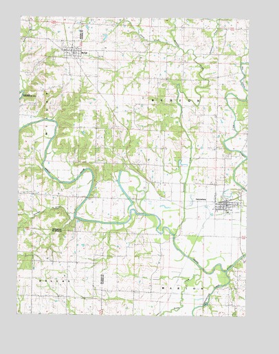
Pattonsburg, MO USGS Topographic Map
Click on map above to begin viewing in our Map Viewer.

This topographic map contains these locations and features:
Feature Name Type Latitude Longitude GNIS ID View Map
Best ChurchChurchN40.0797°W94.2083°714008View Map
City of McFallCivilN40.1116°W94.2223°2395065View Map
Conestoga SchoolSchoolN40.0644°W94.2088°716188View Map
Dilly School (historical)SchoolN40.0636°W94.1716°730087View Map
Elam School (historical)SchoolN40.0519°W94.2430°747025View Map
Goose CreekStreamN40.1128°W94.1636°730024View Map
Grindstone CreekStreamN40.0190°W94.1359°729505View Map
Groomer BranchStreamN40.0419°W94.2191°729506View Map
Heath School (historical)SchoolN40.1214°W94.1555°719321View Map
Jones BranchStreamN40.0936°W94.2480°730026View Map
Koger SchoolSchoolN40.0281°W94.1852°730199View Map
Little Sampson CreekStreamN40.1086°W94.1536°730028View Map
McFallPopulated PlaceN40.1108°W94.2233°722100View Map
McFall CemeteryCemeteryN40.1072°W94.2324°2702167View Map
McFall Fire Protection DistrictBuildingN40.1105°W94.2213°2621366View Map
McFall Post OfficePost OfficeN40.1108°W94.2240°2783007View Map
Muddy CreekStreamN40.0202°W94.1503°729573View Map
Oak Ridge School (historical)SchoolN40.1083°W94.1419°723649View Map
Old PattonsburgPopulated PlaceN40.0467°W94.1358°2561102View Map
Pattonsburg Elementary SchoolSchoolN40.0448°W94.1421°2545230View Map
Round Top School (historical)SchoolN40.0225°W94.2227°729633View Map
Sampson CreekStreamN40.0339°W94.1644°730035View Map
Savage CemeteryCemeteryN40.0539°W94.2080°726069View Map
Township of BentonCivilN40.0847°W94.1609°766576View Map
Walnut Grove School (historical)SchoolN40.0708°W94.1425°747012View Map
Watson Airport (historical)AirportN40.0708°W94.1461°758853View Map
Woodward Lake DamDamN40.0850°W94.2019°762606View Map

Note: Coordinates in the location and feature list above are referenced to NAD83 datum.


Copyright (C) 2008-2024 Ryan Niemi / Sunset Dynamics ... All Rights Reserved