TopoQuest Logo
Do you find TopoQuest useful?
Help keep TopoQuest running and adding new maps/features by donating!
Bitcoin:  19c7KJd3qBynnjoSw5npx9KScwjBe4ifkT
Litecoin:  LXs6TkuXGGXo1vDsWCkWVdjQX94eUKd6ui
Home View Maps Find Maps Find Places Resources & Links


Paragon, Indiana Topographic Map

USGS Map Title: Paragon, IN
USGS Map MRC: 39086D5
DRG (GeoTIFF) Download: o39086d5.tif


Neighboring USGS Topographic Map Quads:


  Eminence, IN  
39086E6
 

  Hall, IN  
39086E5
 

  Mooresville West, IN  
39086E4
 

  Quincy, IN  
39086D6
 

  Paragon, IN  
39086D5
 

  Martinsville, IN  
39086D4
 

  Gosport, IN  
39086C6
 

  Modesto, IN  
39086C5
 

  Hindustan, IN  
39086C4


Map MRC Location:

N40°
W87°
N40°
W86°
H8 H7 H6 H5 H4 H3 H2 H1
G8 G7 G6 G5 G4 G3 G2 G1
F8 F7 F6 F5 F4 F3 F2 F1
E8 E7 E6 E5 E4 E3 E2 E1
D8 D7 D6 D5 D4 D3 D2 D1
C8 C7 C6 C5 C4 C3 C2 C1
B8 B7 B6 B5 B4 B3 B2 B1
A8 A7 A6 A5 A4 A3 A2 A1
N39°
W87°
N39°
W86°

Paragon, IN USGS 1:24K Topographic Map Preview:
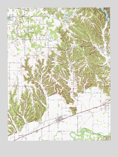
Paragon, IN USGS Topographic Map
Click on map above to begin viewing in our Map Viewer.

This topographic map contains these locations and features:
Feature Name Type Latitude Longitude GNIS ID View Map
Amy LakeReservoirN39.4930°W86.5520°448828View Map
Amy Lake DamDamN39.4934°W86.5539°448827View Map
Bethlehem CemeteryCemeteryN39.4623°W86.5178°430975View Map
Big Hurricane HillSummitN39.4620°W86.5308°431038View Map
Bluebird AirportAirportN39.3916°W86.6002°2677021View Map
Browns CrossingPopulated PlaceN39.4064°W86.5056°431641View Map
Burkhart CreekStreamN39.3856°W86.5367°431838View Map
Butler BranchStreamN39.3912°W86.6025°431898View Map
Corinth ChurchChurchN39.4975°W86.6036°432966View Map
Friendship Park CemeteryCemeteryN39.4028°W86.5489°434869View Map
Gallimore HillSummitN39.4037°W86.5458°434928View Map
Goat HillSummitN39.4173°W86.5542°435140View Map
Goss CemeteryCemeteryN39.3953°W86.5886°435242View Map
Guthrie LakeReservoirN39.4492°W86.5733°448824View Map
Guthrie Lake DamLakeN39.4506°W86.5724°448823View Map
Hodges DitchCanalN39.3789°W86.6031°436268View Map
Hren LakeReservoirN39.4152°W86.5849°448826View Map
Hren Lake DamDamN39.4139°W86.5844°448825View Map
Hynds CemeteryCemeteryN39.4137°W86.5022°436674View Map
Lake MaxineReservoirN39.4908°W86.6241°438746View Map
Lake PrimroseReservoirN39.4885°W86.6237°441599View Map
Lambs Creek ChurchChurchN39.4556°W86.5025°437586View Map
Lingle CemeteryCemeteryN39.4441°W86.6078°437960View Map
Little Hurricane HillSummitN39.4831°W86.5206°438071View Map
McClures Mobile Home ParkPopulated PlaceN39.3975°W86.5578°2515661View Map
Mount Gilead CemeteryCemeteryN39.4043°W86.5073°439564View Map
Olive ChurchChurchN39.4548°W86.5639°440649View Map
ParagonPopulated PlaceN39.3950°W86.5625°440862View Map
Paragon Elementary SchoolSchoolN39.3964°W86.5675°447326View Map
Paragon Fire Station 17BuildingN39.3949°W86.5622°2701422View Map
Paragon Police DepartmentBuildingN39.3951°W86.5638°2758082View Map
Paragon Volunteer Fire DepartmentBuildingN39.3949°W86.5623°2625658View Map
Patton DamDamN39.4867°W86.5033°447879View Map
Patton LakeReservoirN39.4968°W86.5078°440937View Map
PlanoPopulated PlaceN39.4992°W86.6039°441226View Map
Potato MoundPopulated PlaceN39.4081°W86.5422°452136View Map
Ratts CemeteryCemeteryN39.4656°W86.5639°441789View Map
Shumaker HillSummitN39.4925°W86.5689°443469View Map
Stierwalt CemeteryCemeteryN39.4263°W86.6020°444162View Map
Stout CemeteryCemeteryN39.4101°W86.5072°444243View Map
Town of ParagonCivilN39.3947°W86.5628°2396847View Map
Township of AshlandCivilN39.4798°W86.6085°453092View Map
Township of RayCivilN39.4020°W86.5881°453783View Map
WakelandPopulated PlaceN39.4692°W86.5753°445361View Map
WhitakerPopulated PlaceN39.3798°W86.6075°445913View Map

Note: Coordinates in the location and feature list above are referenced to NAD83 datum.


Copyright (C) 2008-2024 Ryan Niemi / Sunset Dynamics ... All Rights Reserved