TopoQuest Logo
Do you find TopoQuest useful?
Help keep TopoQuest running and adding new maps/features by donating!
Bitcoin:  19c7KJd3qBynnjoSw5npx9KScwjBe4ifkT
Litecoin:  LXs6TkuXGGXo1vDsWCkWVdjQX94eUKd6ui
Home View Maps Find Maps Find Places Resources & Links


Paint Rock, Alabama Topographic Map

USGS Map Title: Paint Rock, AL
USGS Map MRC: 34086F3
DRG (GeoTIFF) Download: o34086f3.tif


Neighboring USGS Topographic Map Quads:


  Maysville, AL  
34086G4
 

  Hollytree, AL  
34086G3
 

  Princeton, AL  
34086G2
 

  Moontown, AL  
34086F4
 

  Paint Rock, AL  
34086F3
 

  Lim Rock, AL  
34086F2
 

  New Hope, AL  
34086E4
 

  Grant, AL  
34086E3
 

  Swearengin, AL  
34086E2


Map MRC Location:

N35°
W87°
N35°
W86°
H8 H7 H6 H5 H4 H3 H2 H1
G8 G7 G6 G5 G4 G3 G2 G1
F8 F7 F6 F5 F4 F3 F2 F1
E8 E7 E6 E5 E4 E3 E2 E1
D8 D7 D6 D5 D4 D3 D2 D1
C8 C7 C6 C5 C4 C3 C2 C1
B8 B7 B6 B5 B4 B3 B2 B1
A8 A7 A6 A5 A4 A3 A2 A1
N34°
W87°
N34°
W86°

Paint Rock, AL USGS 1:24K Topographic Map Preview:
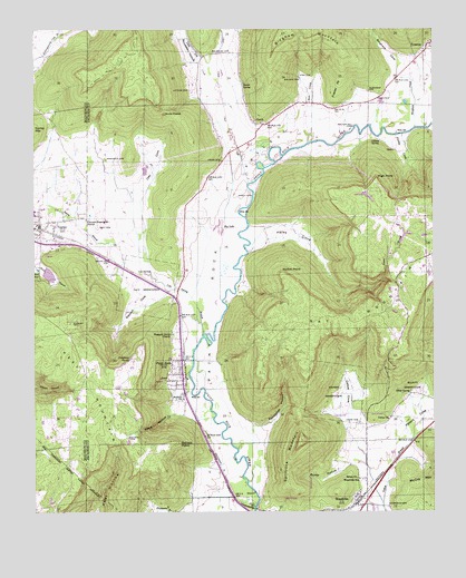
Paint Rock, AL USGS Topographic Map
Click on map above to begin viewing in our Map Viewer.

This topographic map contains these locations and features:
Feature Name Type Latitude Longitude GNIS ID View Map
Antioch ChurchChurchN34.6543°W86.3286°113176View Map
Antioch ChurchChurchN34.6718°W86.3322°139089View Map
Big LakeLakeN34.6976°W86.3160°114295View Map
Bingham CoveValleyN34.7381°W86.2608°114354View Map
Bingham CreekStreamN34.7245°W86.2553°114356View Map
Blair SpringSpringN34.6871°W86.3735°114469View Map
Blue SpringSpringN34.6326°W86.3092°149281View Map
Bucks PocketBasinN34.7279°W86.3342°115147View Map
Bullock CemeteryCemeteryN34.6440°W86.3455°115194View Map
Bullock PointCapeN34.6429°W86.3308°115195View Map
Butler HollowValleyN34.6373°W86.2753°115317View Map
Chalybeate SpringSpringN34.6650°W86.3450°115916View Map
Clay CemeteryCemeteryN34.6987°W86.3550°116197View Map
Clay CoveValleyN34.6956°W86.3422°116200View Map
Clear CreekStreamN34.7104°W86.3078°116233View Map
Cole SpringSpringN34.6869°W86.3420°116408View Map
Cole Spring BranchStreamN34.6712°W86.3219°116409View Map
Conyers-Rosenwald SchoolSchoolN34.7009°W86.3586°116522View Map
Cotton CoveValleyN34.6426°W86.2744°116684View Map
Daniel SpringSpringN34.7362°W86.3092°117052View Map
Elliott ReservationParkN34.6551°W86.2544°117944View Map
Fern Cave National Wildlife RefugeParkN34.6773°W86.3090°149284View Map
Finley CoveValleyN34.7226°W86.2592°118287View Map
Flanagan CemeteryCemeteryN34.7340°W86.2700°118354View Map
Flippo FordCrossingN34.7245°W86.2530°1700329View Map
Fowler CemeteryCemeteryN34.6717°W86.3303°149567View Map
Frazier PointCapeN34.7370°W86.2789°118612View Map
GarthPopulated PlaceN34.7254°W86.3030°154454View Map
Garth ChurchChurchN34.7265°W86.3055°149568View Map
Gilliam SpringSpringN34.7212°W86.2661°118961View Map
Gurley Police DepartmentBuildingN34.6965°W86.3712°2751735View Map
Gurley Volunteer Fire Department Station 1BuildingN34.6961°W86.3712°2682923View Map
Gurley Volunteer Fire Department Station 2BuildingN34.6985°W86.3726°2683402View Map
Hales CoveValleyN34.6926°W86.3080°119563View Map
Hales Cove School (historical)SchoolN34.7006°W86.3072°139179View Map
Haley SpringSpringN34.6783°W86.3142°149282View Map
High PointCapeN34.7112°W86.2675°120059View Map
Holly Spring School (historical)SchoolN34.6912°W86.2525°1700332View Map
Holly Springs School (historical)SchoolN34.6890°W86.2589°139187View Map
Jones CemeteryCemeteryN34.7159°W86.3161°120995View Map
Keel Mountain Volunteer Fire DepartmentBuildingN34.6426°W86.3640°2682793View Map
Kennamer HollowValleyN34.6468°W86.3069°121144View Map
Kirk CemeteryCemeteryN34.7379°W86.2919°121249View Map
Kirk CoveValleyN34.7273°W86.2903°121250View Map
Lacy ReservationParkN34.6840°W86.3369°121306View Map
Latham CemeteryCemeteryN34.7342°W86.3261°121406View Map
Laurel BranchStreamN34.6926°W86.3080°121419View Map
Little Dry CreekStreamN34.7359°W86.3172°121783View Map
Naught MineMineN34.7404°W86.2961°139230View Map
Nolton PointCapeN34.6862°W86.2972°123966View Map
Paint RockPopulated PlaceN34.6606°W86.3289°154485View Map
Paint Rock CemeteryCemeteryN34.6565°W86.3311°149584View Map
Paint Rock ChurchChurchN34.6648°W86.3294°149585View Map
Paint Rock DivisionCivilN34.6776°W86.2565°165807View Map
Paint Rock Post OfficePost OfficeN34.6599°W86.3294°2789099View Map
Paint Rock ValleyValleyN34.6251°W86.3064°124378View Map
Paint Rock Volunteer Fire DepartmentBuildingN34.6660°W86.3295°2683218View Map
Peters CoveValleyN34.6431°W86.2575°124642View Map
Pleasant Grove Baptist ChurchChurchN34.6712°W86.3319°152985View Map
Roberson CemeteryCemeteryN34.7165°W86.3525°125691View Map
Ross CemeteryCemeteryN34.6834°W86.2619°149590View Map
Rousseau CemeteryCemeteryN34.7442°W86.3133°125990View Map
Rousseau CemeteryCemeteryN34.7320°W86.3086°149592View Map
Rousseau HollowValleyN34.7381°W86.3203°125991View Map
Saint Clair Grist Mill (historical)LocaleN34.7201°W86.2805°1959058View Map
Serotas SpringSpringN34.6973°W86.3167°139286View Map
Shanty BranchStreamN34.6879°W86.3414°126629View Map
Shiloh ChurchChurchN34.6337°W86.2742°126755View Map
Smith CemeteryCemeteryN34.7329°W86.2664°127007View Map
Smith, Walker and Johnson LakeReservoirN34.6865°W86.3703°132036View Map
Smith, Walker and Johnson Lake DamDamN34.6868°W86.3717°132037View Map
Smiths Mill (historical)LocaleN34.7254°W86.2703°139290View Map
Splitrock MountainSummitN34.6434°W86.2917°153520View Map
Spout SpringSpringN34.6557°W86.2575°127198View Map
Stephens CemeteryCemeteryN34.6265°W86.2641°127357View Map
Stevens ReservationParkN34.6556°W86.2800°127369View Map
Stewart CemeteryCemeteryN34.6740°W86.3633°127384View Map
Stewart CoveValleyN34.6818°W86.3336°127386View Map
Town of Paint RockCivilN34.6602°W86.3307°2407066View Map
Town of WoodvilleCivilN34.6256°W86.2792°2406914View Map
TrentonPopulated PlaceN34.7448°W86.2517°128063View Map
Trenton ChurchChurchN34.7468°W86.2511°149600View Map
Union CemeteryCemeteryN34.6481°W86.2739°128271View Map
Union ChurchChurchN34.6490°W86.2639°128302View Map
Valley Volunteer Fire Department Station 2BuildingN34.7453°W86.2504°2683418View Map
Walker CemeteryCemeteryN34.7373°W86.2916°128510View Map
Walker Mill FordCrossingN34.7248°W86.2742°157210View Map
Walkers Mill (historical)LocaleN34.7254°W86.2744°1700343View Map
Webb HollowValleyN34.6504°W86.3311°128685View Map
Wells FordCrossingN34.7073°W86.3061°157231View Map
WoodvillePopulated PlaceN34.6279°W86.2744°129219View Map
Woodville Post OfficePost OfficeN34.6259°W86.2731°2788937View Map
Woodville SchoolSchoolN34.6334°W86.2733°129221View Map
Woodville Volunteer Fire DepartmentBuildingN34.6266°W86.2725°2682896View Map

Note: Coordinates in the location and feature list above are referenced to NAD83 datum.


Copyright (C) 2008-2024 Ryan Niemi / Sunset Dynamics ... All Rights Reserved