TopoQuest Logo
Do you find TopoQuest useful?
Help keep TopoQuest running and adding new maps/features by donating!
Bitcoin:  19c7KJd3qBynnjoSw5npx9KScwjBe4ifkT
Litecoin:  LXs6TkuXGGXo1vDsWCkWVdjQX94eUKd6ui
Home View Maps Find Maps Find Places Resources & Links


Pacific, Missouri Topographic Map

USGS Map Title: Pacific, MO
USGS Map MRC: 38090D6
DRG (GeoTIFF) Download: o38090d6.tif


Neighboring USGS Topographic Map Quads:


  Labadie, MO  
38090E7
 

  Eureka, MO  
38090E6
 

  Manchester, MO  
38090E5
 

  Gray Summit, MO  
38090D7
 

  Pacific, MO  
38090D6
 

  House Springs, MO  
38090D5
 

  Lonedell, MO  
38090C7
 

  Cedar Hill, MO  
38090C6
 

  Belews Creek, MO  
38090C5


Map MRC Location:

N39°
W91°
N39°
W90°
H8 H7 H6 H5 H4 H3 H2 H1
G8 G7 G6 G5 G4 G3 G2 G1
F8 F7 F6 F5 F4 F3 F2 F1
E8 E7 E6 E5 E4 E3 E2 E1
D8 D7 D6 D5 D4 D3 D2 D1
C8 C7 C6 C5 C4 C3 C2 C1
B8 B7 B6 B5 B4 B3 B2 B1
A8 A7 A6 A5 A4 A3 A2 A1
N38°
W91°
N38°
W90°

Pacific, MO USGS 1:24K Topographic Map Preview:
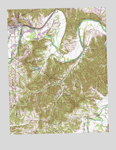
Pacific, MO USGS Topographic Map
Click on map above to begin viewing in our Map Viewer.

This topographic map contains these locations and features:
Feature Name Type Latitude Longitude GNIS ID View Map
Alfred Buhl, Junior Lake DamDamN38.4251°W90.7018°764273View Map
Allenton SchoolSchoolN38.4989°W90.6743°755684View Map
Ashland (historical)Populated PlaceN38.4564°W90.6818°757487View Map
Bald HillSummitN38.4851°W90.6304°755717View Map
Brush CreekStreamN38.4798°W90.7329°755825View Map
Buck CreekStreamN38.3862°W90.6511°714958View Map
Buhl LakeReservoirN38.4251°W90.7018°764274View Map
ByrnesvillePopulated PlaceN38.3928°W90.6398°715169View Map
Byrnesville School (historical)SchoolN38.3937°W90.6521°737676View Map
Camp Solidarity Lake DamDamN38.4517°W90.7401°764363View Map
Car LakeReservoirN38.4084°W90.6446°764278View Map
Catawissa HollowValleyN38.4145°W90.7240°715492View Map
Cedar Hill Fire Protection District Station 3BuildingN38.3873°W90.6726°2467905View Map
Clear CreekStreamN38.4787°W90.7168°755897View Map
Crystal Lake DamDamN38.4284°W90.6935°764271View Map
Duncan Lake DamDamN38.4567°W90.7218°765150View Map
Eureka Fire Protection District House 1 HeadquartersBuildingN38.4928°W90.6309°2620976View Map
Eureka Fire Protection District Training CenterBuildingN38.4871°W90.7025°2620444View Map
Father Dunn CampLocaleN38.4273°W90.6790°717863View Map
First Central Services Lake DamDamN38.4484°W90.7151°764243View Map
Fox CreekStreamN38.4567°W90.6849°756075View Map
Fun Valley DamDamN38.4584°W90.7235°764195View Map
Fun Valley LakeReservoirN38.4576°W90.7253°764196View Map
Geggie Elementary SchoolSchoolN38.4946°W90.6321°2469383View Map
Gem LakeReservoirN38.4267°W90.6985°764276View Map
Gem Lake DamDamN38.4267°W90.6985°764275View Map
La Barque CreekStreamN38.4542°W90.6568°720709View Map
La Barque CreekPopulated PlaceN38.4231°W90.6825°2630712View Map
La Barque HillsAreaN38.4294°W90.6589°737677View Map
Labargue School (historical)SchoolN38.4445°W90.6690°737675View Map
LaBarque Creek Census Designated PlaceCensusN38.4162°W90.6777°2583783View Map
LaBarque Creek Conservation AreaParkN38.4213°W90.7019°2567164View Map
Lake TekakwithaReservoirN38.4405°W90.7146°764126View Map
Lake Tekawitha DamDamN38.4417°W90.7118°764125View Map
Lost HillSummitN38.4753°W90.6987°756329View Map
Lynch LakeReservoirN38.4075°W90.7397°764397View Map
Lynch Lake DamDamN38.4084°W90.7401°764396View Map
McFall CreekStreamN38.4506°W90.6862°722102View Map
McNamee School (historical)SchoolN38.4478°W90.7160°737673View Map
Missouri Eastern Correctional CenterBuildingN38.4907°W90.7010°2735655View Map
Our Lady of Czestochowa ChurchChurchN38.4126°W90.6829°723888View Map
PacificPopulated PlaceN38.4820°W90.7415°731630View Map
Pacific Fire Protection District Station 3BuildingN38.4657°W90.7309°2621382View Map
Pacific Post OfficePost OfficeN38.4819°W90.7450°2782844View Map
Pacific SchoolSchoolN38.4834°W90.7460°730629View Map
Rock ChurchChurchN38.4031°W90.7446°725436View Map
Rustic Hills LakeReservoirN38.4106°W90.6685°764280View Map
Rustic Hills Lake DamDamN38.4101°W90.6701°764279View Map
Saint Josephs Hill InfirmaryHospitalN38.4142°W90.6876°736340View Map
Saint Patricks School (historical)SchoolN38.4028°W90.7446°730628View Map
Saint Stephens ChurchChurchN38.4892°W90.6576°756682View Map
Sand CreekStreamN38.3853°W90.6337°726006View Map
Scheve Community CenterLocaleN38.3781°W90.7176°726098View Map
Scheve School (historical)SchoolN38.3784°W90.7010°737674View Map
Township of MeramecCivilN38.3933°W90.6431°766825View Map
Village of Lake TekakwithaCivilN38.4418°W90.7147°2585135View Map
Woodcliff Lake DamDamN38.4084°W90.6435°764277View Map
Zeman Lake DamDamN38.4317°W90.6851°764244View Map

Note: Coordinates in the location and feature list above are referenced to NAD83 datum.


Copyright (C) 2008-2024 Ryan Niemi / Sunset Dynamics ... All Rights Reserved