TopoQuest Logo
Do you find TopoQuest useful?
Help keep TopoQuest running and adding new maps/features by donating!
Bitcoin:  19c7KJd3qBynnjoSw5npx9KScwjBe4ifkT
Litecoin:  LXs6TkuXGGXo1vDsWCkWVdjQX94eUKd6ui
Home View Maps Find Maps Find Places Resources & Links


Osbornville, North Carolina Topographic Map

USGS Map Title: Osbornville, NC
USGS Map MRC: 36080A8
DRG (GeoTIFF) Download: o36080a8.tif


Neighboring USGS Topographic Map Quads:


  Roaring River, NC  
36081B1
 

  Ronda, NC  
36080B8
 

  Elkin South, NC  
36080B7
 

  Gilreath, NC  
36081A1
 

  Osbornville, NC  
36080A8
 

  Brooks Crossroads, NC  
36080A7
 

  Hiddenite, NC  
35081H1
 

  Central, NC  
35080H8
 

  Harmony, NC  
35080H7


Map MRC Location:

N37°
W81°
N37°
W80°
H8 H7 H6 H5 H4 H3 H2 H1
G8 G7 G6 G5 G4 G3 G2 G1
F8 F7 F6 F5 F4 F3 F2 F1
E8 E7 E6 E5 E4 E3 E2 E1
D8 D7 D6 D5 D4 D3 D2 D1
C8 C7 C6 C5 C4 C3 C2 C1
B8 B7 B6 B5 B4 B3 B2 B1
A8 A7 A6 A5 A4 A3 A2 A1
N36°
W81°
N36°
W80°

Osbornville, NC USGS 1:24K Topographic Map Preview:
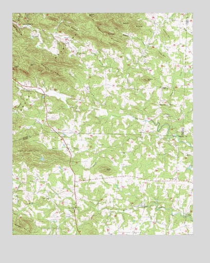
Osbornville, NC USGS Topographic Map
Click on map above to begin viewing in our Map Viewer.

This topographic map contains these locations and features:
Feature Name Type Latitude Longitude GNIS ID View Map
Bailey MountainSummitN36.1179°W80.9148°1018904View Map
Bald MountainSummitN36.1193°W80.9242°980473View Map
Bear BranchStreamN36.1174°W80.9951°980696View Map
Bear MountainSummitN36.1160°W80.9984°1019004View Map
Bee KnobSummitN36.1132°W80.9345°1019044View Map
Brushy CreekStreamN36.0549°W80.8909°982060View Map
Bussels CreekStreamN36.0829°W80.9945°982326View Map
Cass DamDamN36.0385°W80.8765°999949View Map
Cass Fishing LakeReservoirN36.0380°W80.8772°999950View Map
Clercy BranchStreamN36.1179°W80.9892°983275View Map
Cooter HollowValleyN36.0722°W80.9389°983520View Map
Dishmon CreekStreamN36.0137°W80.9945°984200View Map
Dugger CreekStreamN36.0910°W80.9195°984398View Map
Fitches KnobSummitN36.0949°W80.9990°1020259View Map
Friendship ChurchChurchN36.0304°W80.9834°985453View Map
Grassy KnobSummitN36.0371°W80.9351°985968View Map
Grassy Knob ChurchChurchN36.0460°W80.9215°985970View Map
Harris MountainSummitN36.1151°W80.9570°986454View Map
Hickory MountainSummitN36.1126°W80.8937°1020714View Map
JenningsPopulated PlaceN36.0121°W80.8803°1020945View Map
Johnson DamDamN36.1118°W80.9865°1000094View Map
Little Hunting CreekStreamN36.0646°W80.9084°988670View Map
Lovelace (historical)Populated PlaceN36.0724°W80.9537°1002166View Map
Mathis DamDamN36.0435°W80.9781°999969View Map
Mathis LakeReservoirN36.0428°W80.9795°999970View Map
Mount Calvary ChurchChurchN36.0449°W80.8792°990336View Map
Mount Pisgah ChurchChurchN36.0687°W80.9754°990512View Map
Mountain View ChurchChurchN36.1124°W80.9817°990724View Map
Nesbert HillSummitN36.0957°W80.9884°1021619View Map
New CastlePopulated PlaceN36.1074°W80.9059°1805898View Map
New HopePopulated PlaceN36.0149°W80.9565°1006310View Map
NonameReservoirN36.1118°W80.9865°1000095View Map
Osborn CreekStreamN36.0568°W80.8865°991700View Map
OsbornvillePopulated PlaceN36.0757°W80.8976°1006320View Map
Pasture Bottom CreekStreamN36.0490°W80.9287°991906View Map
Piney MountainSummitN36.1012°W80.8973°1021971View Map
Prevette RidgeRidgeN36.0924°W80.9731°992800View Map
Redmond MountainSummitN36.0468°W80.9917°1022208View Map
Ringfire MountainSummitN36.0876°W80.9073°993364View Map
Roberts MountainSummitN36.1129°W80.9348°1022319View Map
Sam BranchStreamN36.1182°W80.9965°994202View Map
Shady Grove ChurchChurchN36.1015°W80.9540°994555View Map
Shumaker MountainSummitN36.0026°W80.9912°1022624View Map
Smyths ChapelChurchN36.0315°W80.8865°995036View Map
Somers CrossroadsPopulated PlaceN36.0835°W80.8965°1006379View Map
Sweet Home ChurchChurchN36.0676°W80.8917°995779View Map
Taylor Springs Baptist ChurchChurchN36.0212°W80.9745°995893View Map
Templeton Store (historical)LocaleN36.0585°W80.9592°1805899View Map
Township of New HopeCivilN36.0157°W80.9571°1026821View Map
Township of SomersCivilN36.0924°W80.9391°1027336View Map
Union ChurchChurchN36.1212°W80.8898°996461View Map
Wallace MountainSummitN36.1237°W80.9476°1023105View Map
Wilkes - Iredell Volunteer Fire DepartmentBuildingN36.0674°W80.9757°2638938View Map
Windy GapPopulated PlaceN36.1185°W80.9895°1023280View Map
Zimmerman (historical)Populated PlaceN36.0832°W80.9937°1002190View Map
Zion (historical)Populated PlaceN36.0437°W80.8987°1001764View Map

Note: Coordinates in the location and feature list above are referenced to NAD83 datum.


Copyright (C) 2008-2024 Ryan Niemi / Sunset Dynamics ... All Rights Reserved