TopoQuest Logo
Do you find TopoQuest useful?
Help keep TopoQuest running and adding new maps/features by donating!
Bitcoin:  19c7KJd3qBynnjoSw5npx9KScwjBe4ifkT
Litecoin:  LXs6TkuXGGXo1vDsWCkWVdjQX94eUKd6ui
Home View Maps Find Maps Find Places Resources & Links


Orson, Pennsylvania Topographic Map

USGS Map Title: Orson, PA
USGS Map MRC: 41075G4
DRG (GeoTIFF) Download: o41075g4.tif


Neighboring USGS Topographic Map Quads:


  Susquehanna, PA  
41075H5
 

  Starrucca, PA  
41075H4
 

  Hancock, NY  
41075H3
 

  Thompson, PA  
41075G5
 

  Orson, PA  
41075G4
 

  Lake Como, PA  
41075G3
 

  Clifford, PA  
41075F5
 

  Forest City, PA  
41075F4
 

  Aldenville, PA  
41075F3


Map MRC Location:

N42°
W76°
N42°
W75°
H8 H7 H6 H5 H4 H3 H2 H1
G8 G7 G6 G5 G4 G3 G2 G1
F8 F7 F6 F5 F4 F3 F2 F1
E8 E7 E6 E5 E4 E3 E2 E1
D8 D7 D6 D5 D4 D3 D2 D1
C8 C7 C6 C5 C4 C3 C2 C1
B8 B7 B6 B5 B4 B3 B2 B1
A8 A7 A6 A5 A4 A3 A2 A1
N41°
W76°
N41°
W75°

Orson, PA USGS 1:24K Topographic Map Preview:
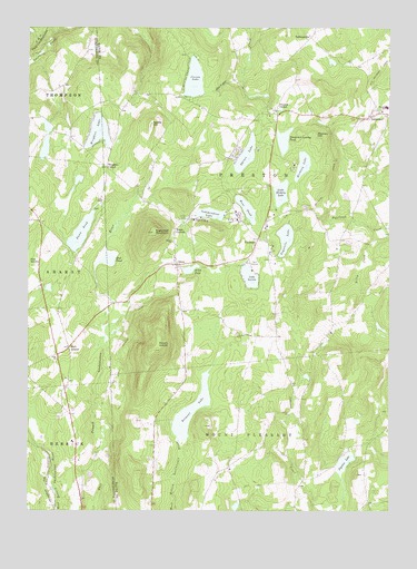
Orson, PA USGS Topographic Map
Click on map above to begin viewing in our Map Viewer.

This topographic map contains these locations and features:
Feature Name Type Latitude Longitude GNIS ID View Map
Belmont LakeReservoirN41.7762°W75.4429°1169203View Map
Belmont Lake DamDamN41.7684°W75.4463°1195788View Map
Biglow LakeLakeN41.7628°W75.3898°1169614View Map
Boden AirportAirportN41.8482°W75.4458°1194298View Map
Bone PondLakeN41.8282°W75.4241°1169973View Map
Coxton LakeLakeN41.8616°W75.4424°1172568View Map
Dix School (historical)SchoolN41.8723°W75.4191°1197767View Map
Dunn PondLakeN41.8221°W75.4814°1173620View Map
East AraratPopulated PlaceN41.7923°W75.4857°1203468View Map
East Ararat School (historical)SchoolN41.7929°W75.4855°1197765View Map
Free ChurchChurchN41.7895°W75.4893°1175202View Map
Fulkerson SchoolSchoolN41.7654°W75.4266°1197763View Map
Giles and Sikorsky Airport (historical)AirportN41.7834°W75.4330°1194287View Map
Hickory LakeLakeN41.8395°W75.4048°1176965View Map
Hines CornersLocaleN41.8229°W75.4482°1177135View Map
Independent LakeLakeN41.8269°W75.4366°1177730View Map
Lake LorainLakeN41.8106°W75.4230°1179946View Map
LakewoodPopulated PlaceN41.8520°W75.3813°1178810View Map
Lakewood Post OfficePost OfficeN41.8517°W75.3823°2779694View Map
Little Hickory LakeLakeN41.8323°W75.4122°1179561View Map
Monroe School (historical)SchoolN41.7584°W75.4043°1197764View Map
Moores HillSummitN41.8468°W75.3996°1181513View Map
Mount AraratSummitN41.7915°W75.4555°1168365View Map
Mud PondLakeN41.8151°W75.4716°1182016View Map
Mulligan Airport (historical)AirportN41.8001°W75.4246°1194290View Map
Nettle HillSummitN41.8501°W75.4566°1182272View Map
OrsonPopulated PlaceN41.8137°W75.4480°1183050View Map
Orson CemeteryCemeteryN41.8259°W75.4443°1183051View Map
Orson ChurchChurchN41.8198°W75.4493°1183052View Map
Orson FieldAirportN41.8433°W75.4358°2442893View Map
Orson PondReservoirN41.8126°W75.4436°1183053View Map
Orson Pond DamDamN41.8134°W75.4463°1195804View Map
PoyntellePopulated PlaceN41.8206°W75.4199°1204443View Map
Poyntelle LakeLakeN41.8205°W75.4107°1184379View Map
Poyntelle Post OfficePost OfficeN41.8249°W75.4175°2780028View Map
Preston CenterLocaleN41.8537°W75.4130°1184399View Map
South Preston SchoolSchoolN41.8068°W75.3952°1197766View Map
Spruce LakeLakeN41.8420°W75.4244°1188335View Map
Stevenson School (historical)SchoolN41.7745°W75.4555°1197762View Map
Sugarloaf MountainSummitN41.8223°W75.4557°1188997View Map
TallmanvillePopulated PlaceN41.8726°W75.4018°1204797View Map
Tamarack Swamp PondLakeN41.8459°W75.4114°1189252View Map
Township of PrestonCivilN41.8414°W75.3991°1217249View Map
Watson Airport (historical)AirportN41.8134°W75.4485°1194292View Map
Wrighter CornerPopulated PlaceN41.8390°W75.4724°1204995View Map
Wrighter LakeLakeN41.8482°W75.4756°1191808View Map

Note: Coordinates in the location and feature list above are referenced to NAD83 datum.


Copyright (C) 2008-2024 Ryan Niemi / Sunset Dynamics ... All Rights Reserved