TopoQuest Logo
Do you find TopoQuest useful?
Help keep TopoQuest running and adding new maps/features by donating!
Bitcoin:  19c7KJd3qBynnjoSw5npx9KScwjBe4ifkT
Litecoin:  LXs6TkuXGGXo1vDsWCkWVdjQX94eUKd6ui
Home View Maps Find Maps Find Places Resources & Links


Benkelman, Nebraska Topographic Map

USGS Map Title: Benkelman, NE
USGS Map MRC: 40101A5
DRG (GeoTIFF) Download: o40101a5.tif


Neighboring USGS Topographic Map Quads:


  Benkelman NW, NE  
40101B6
 

  Arrowhead Lake, NE  
40101B5
 

  Rock Canyon, NE  
40101B4
 

  Parks, NE  
40101A6
 

  Benkelman, NE  
40101A5
 

  Max, NE  
40101A4
 

  Heinzelman Canyon, KS  
39101H6
 

  Henkle Canyon, KS  
39101H5
 

  McDonald NW, KS  
39101H4


Map MRC Location:

N41°
W102°
N41°
W101°
H8 H7 H6 H5 H4 H3 H2 H1
G8 G7 G6 G5 G4 G3 G2 G1
F8 F7 F6 F5 F4 F3 F2 F1
E8 E7 E6 E5 E4 E3 E2 E1
D8 D7 D6 D5 D4 D3 D2 D1
C8 C7 C6 C5 C4 C3 C2 C1
B8 B7 B6 B5 B4 B3 B2 B1
A8 A7 A6 A5 A4 A3 A2 A1
N40°
W102°
N40°
W101°

Benkelman, NE USGS 1:24K Topographic Map Preview:
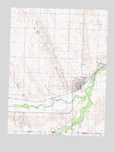
Benkelman, NE USGS Topographic Map
Click on map above to begin viewing in our Map Viewer.

This topographic map contains these locations and features:
Feature Name Type Latitude Longitude GNIS ID View Map
Baney Trailer ParkPopulated PlaceN40.0492°W101.5329°1838944View Map
Barnes CreekStreamN40.0294°W101.6004°827189View Map
BenkelmanLocaleN40.0472°W101.5332°1838942View Map
BenkelmanPopulated PlaceN40.0492°W101.5329°827319View Map
Benkelman CemeteryCemeteryN40.0698°W101.5327°827320View Map
Benkelman Elementary SchoolSchoolN40.0528°W101.5307°1838924View Map
Benkelman ElevatorsLocaleN40.0475°W101.5329°1838921View Map
Benkelman Golf ClubLocaleN40.0417°W101.5421°1838943View Map
Benkelman Police DepartmentBuildingN40.0507°W101.5336°1838939View Map
Benkelman Police DepartmentBuildingN40.0502°W101.5329°1838940View Map
Benkelman Post OfficePost OfficeN40.0484°W101.5331°1838926View Map
Benkelman State Fish HatcheryLocaleN40.0706°W101.5096°836024View Map
Benkelman TownshipCivilN40.0500°W101.5333°2702074View Map
Benkelman Volunteer Fire DepartmentBuildingN40.0506°W101.5319°2553245View Map
Benkelman Womans Club LibraryBuildingN40.0503°W101.5307°1838920View Map
Big Timber CreekStreamN40.0179°W101.5285°470847View Map
Burrows Vision ClinicHospitalN40.0500°W101.5332°1838931View Map
City of BenkelmanCivilN40.0517°W101.5354°2394133View Map
DoaneLocaleN40.0353°W101.6249°1838948View Map
Doane SchoolSchoolN40.0367°W101.6241°828742View Map
Dundy County Ambulance BenkelmanBuildingN40.0507°W101.5335°2553774View Map
Dundy County CourthouseBuildingN40.0508°W101.5335°1838941View Map
Dundy County FairgroundsLocaleN40.0444°W101.5310°1838946View Map
Dundy County High SchoolSchoolN40.0525°W101.5379°1838923View Map
Dundy County HospitalHospitalN40.0565°W101.5376°1838929View Map
Dundy County Hospital ClinicHospitalN40.0561°W101.5379°1838928View Map
Dundy County MuseumBuildingN40.0489°W101.5341°1838922View Map
Friends ChurchChurchN40.0528°W101.5421°1838937View Map
General Custer in Nebraska Historical MarkerParkN40.0444°W101.5421°1838949View Map
Harvest Time Assembly of God ChurchChurchN40.0511°W101.5299°1838936View Map
Hester Memorial HomeHospitalN40.0472°W101.5382°1838930View Map
Hoppy's AirportAirportN40.0860°W101.5692°837492View Map
Jones AirportAirportN40.0570°W101.5465°837491View Map
Merklin Trailer CourtPopulated PlaceN40.0519°W101.5318°1838897View Map
Rainbow Fountain ParkPopulated PlaceN40.0492°W101.5329°1838945View Map
Republican River Family ClinicHospitalN40.0578°W101.5329°1838925View Map
Saint Josephs Catholic ChurchChurchN40.0519°W101.5374°1838938View Map
South Fork Republican RiverStreamN40.0417°W101.5213°833592View Map
Spring CreekStreamN40.0378°W101.5299°833695View Map
Township of BenkelmanCivilN40.0500°W101.5338°1848383View Map
Trinity Baptist ChurchChurchN40.0506°W101.5349°1838935View Map
Twin Forks Clinic IncorporatedHospitalN40.0578°W101.5329°1838927View Map
Twin LakesReservoirN40.1022°W101.5908°834241View Map
United Methodist ChurchChurchN40.0514°W101.5335°1838934View Map
United Presbyterian ChurchChurchN40.0486°W101.5343°1838933View Map
Ward Bond Memorial ParkParkN40.0453°W101.5377°1838898View Map
Zion Lutheran ChurchChurchN40.0494°W101.5374°1838932View Map

Note: Coordinates in the location and feature list above are referenced to NAD83 datum.


Copyright (C) 2008-2024 Ryan Niemi / Sunset Dynamics ... All Rights Reserved