TopoQuest Logo
Do you find TopoQuest useful?
Help keep TopoQuest running and adding new maps/features by donating!
Bitcoin:  19c7KJd3qBynnjoSw5npx9KScwjBe4ifkT
Litecoin:  LXs6TkuXGGXo1vDsWCkWVdjQX94eUKd6ui
Home View Maps Find Maps Find Places Resources & Links


Onycha, Alabama Topographic Map

USGS Map Title: Onycha, AL
USGS Map MRC: 31086B3
DRG (GeoTIFF) Download: o31086b3.tif


Neighboring USGS Topographic Map Quads:


  Andalusia, AL  
31086C4
 

  Opp West, AL  
31086C3
 

  Opp East, AL  
31086C2
 

  Libertyville, AL  
31086B4
 

  Onycha, AL  
31086B3
 

  Kinston, AL  
31086B2
 

  Watkins Bridge, AL  
31086A4
 

  Florala, AL  
31086A3
 

  Hacoda, AL  
31086A2


Map MRC Location:

N32°
W87°
N32°
W86°
H8 H7 H6 H5 H4 H3 H2 H1
G8 G7 G6 G5 G4 G3 G2 G1
F8 F7 F6 F5 F4 F3 F2 F1
E8 E7 E6 E5 E4 E3 E2 E1
D8 D7 D6 D5 D4 D3 D2 D1
C8 C7 C6 C5 C4 C3 C2 C1
B8 B7 B6 B5 B4 B3 B2 B1
A8 A7 A6 A5 A4 A3 A2 A1
N31°
W87°
N31°
W86°

Onycha, AL USGS 1:24K Topographic Map Preview:
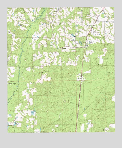
Onycha, AL USGS Topographic Map
Click on map above to begin viewing in our Map Viewer.

This topographic map contains these locations and features:
Feature Name Type Latitude Longitude GNIS ID View Map
Adams PondReservoirN31.2235°W86.2994°159050View Map
Belle School (historical)SchoolN31.1432°W86.3613°162920View Map
Blue SpringsPopulated PlaceN31.2091°W86.3130°159215View Map
Blue Springs Baptist ChurchChurchN31.2091°W86.3133°162350View Map
Craw PondReservoirN31.1450°W86.3457°159461View Map
Danley Estates Lake DamDamN31.2135°W86.2900°161299View Map
Danley Park LakeReservoirN31.2157°W86.2904°159482View Map
David Cravey Lake DamDamN31.1318°W86.3683°161286View Map
Day PondReservoirN31.2179°W86.2977°159490View Map
Dry CreekStreamN31.1299°W86.3672°159521View Map
Green BayPopulated PlaceN31.1780°W86.2894°159694View Map
Horn HillPopulated PlaceN31.2457°W86.3166°159803View Map
Hudgens PondReservoirN31.2149°W86.2787°159821View Map
Indian CreekStreamN31.1818°W86.3600°159841View Map
James Cravey DamDamN31.1435°W86.3466°161287View Map
Jerry Adams DamDamN31.2235°W86.3000°161300View Map
Johnny Cravey DamDamN31.1285°W86.3750°161285View Map
Lawrence Lookout TowerTowerN31.1274°W86.2599°164362View Map
Lawrence PondReservoirN31.1333°W86.3665°159917View Map
Lightwood Knot CreekStreamN31.2482°W86.3316°159945View Map
Magnolia Church (historical)ChurchN31.2179°W86.3402°161638View Map
Mount Olive Bible ChurchChurchN31.2363°W86.3144°163419View Map
Mulberry CreekStreamN31.1877°W86.3561°160201View Map
New Hope Missionary Baptist ChurchChurchN31.1566°W86.3086°160236View Map
OnychaPopulated PlaceN31.2141°W86.2833°160317View Map
Onycha Volunteer Fire DepartmentBuildingN31.2286°W86.2773°2331067View Map
Prices CreekStreamN31.1743°W86.3616°160447View Map
Taylor Mill CreekStreamN31.2346°W86.3455°160722View Map
Taylor PondReservoirN31.2328°W86.3608°160723View Map
Town of Horn HillCivilN31.2382°W86.3211°2405862View Map
Town of OnychaCivilN31.2246°W86.2785°2407049View Map
Welcome the Way Baptist ChurchChurchN31.2349°W86.2919°163427View Map
Yellow River (historical)LocaleN31.1905°W86.3541°161645View Map

Note: Coordinates in the location and feature list above are referenced to NAD83 datum.


Copyright (C) 2008-2024 Ryan Niemi / Sunset Dynamics ... All Rights Reserved