TopoQuest Logo
Do you find TopoQuest useful?
Help keep TopoQuest running and adding new maps/features by donating!
Bitcoin:  19c7KJd3qBynnjoSw5npx9KScwjBe4ifkT
Litecoin:  LXs6TkuXGGXo1vDsWCkWVdjQX94eUKd6ui
Home View Maps Find Maps Find Places Resources & Links


Benedict, Georgia Topographic Map

USGS Map Title: Benedict, GA
USGS Map MRC: 33085H3
DRG (GeoTIFF) Download: o33085h3.tif


Neighboring USGS Topographic Map Quads:


  Indian Mountain, AL  
34085A4
 

  Cedartown West, GA  
34085A3
 

  Cedartown East, GA  
34085A2
 

  Borden Springs, AL  
33085H4
 

  Benedict, GA  
33085H3
 

  Felton, GA  
33085H2
 

  Oak Level, AL  
33085G4
 

  Tallapoosa North, GA  
33085G3
 

  Buchanan, GA  
33085G2


Map MRC Location:

N34°
W86°
N34°
W85°
H8 H7 H6 H5 H4 H3 H2 H1
G8 G7 G6 G5 G4 G3 G2 G1
F8 F7 F6 F5 F4 F3 F2 F1
E8 E7 E6 E5 E4 E3 E2 E1
D8 D7 D6 D5 D4 D3 D2 D1
C8 C7 C6 C5 C4 C3 C2 C1
B8 B7 B6 B5 B4 B3 B2 B1
A8 A7 A6 A5 A4 A3 A2 A1
N33°
W86°
N33°
W85°

Benedict, GA USGS 1:24K Topographic Map Preview:
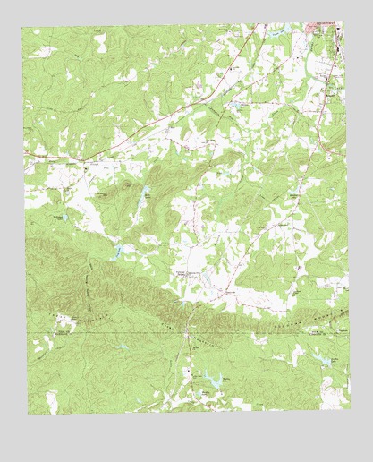
Benedict, GA USGS Topographic Map
Click on map above to begin viewing in our Map Viewer.

This topographic map contains these locations and features:
Feature Name Type Latitude Longitude GNIS ID View Map
AkesPopulated PlaceN33.9673°W85.3180°354268View Map
BenedictPopulated PlaceN33.9740°W85.2572°331132View Map
Benedict Baptist ChurchChurchN33.9787°W85.2594°343523View Map
Benedict SchoolSchoolN33.9820°W85.2572°311076View Map
Benedicts MillLocaleN33.9804°W85.2566°343524View Map
Benedicts PondReservoirN33.9788°W85.2567°343525View Map
Bentley LakeReservoirN33.9459°W85.2703°311099View Map
Berry Grove ChurchChurchN33.9982°W85.2594°354557View Map
Big Cedar Creek Structure Number 13 DamDamN33.9434°W85.3583°339095View Map
Blooming Grove ChurchChurchN33.9198°W85.3119°311531View Map
Brewster MountainSummitN33.9454°W85.3422°311757View Map
Brewster SchoolSchoolN33.9854°W85.2938°311758View Map
Casey MountainSummitN33.9009°W85.3161°331338View Map
CaseyvillePopulated PlaceN33.9132°W85.2980°331339View Map
Cedar Valley Country ClubLocaleN33.9815°W85.2544°344204View Map
Cedartown DivisionCivilN33.9962°W85.2749°1936168View Map
Cleveland ChapelChurchN33.9126°W85.2711°312739View Map
Culp LakeReservoirN33.9267°W85.3395°355403View Map
Culp Lake DamDamN33.9293°W85.3394°337627View Map
Devils Darning Needle HollowValleyN33.9262°W85.3498°313455View Map
DugdownPopulated PlaceN33.9001°W85.2550°331594View Map
Dugdown ChurchChurchN33.8982°W85.2508°350627View Map
Dugdown MountainSummitN33.9009°W85.2700°331595View Map
Elder LakesReservoirN33.9467°W85.3283°355664View Map
Esom SloughStreamN33.9540°W85.3397°159578View Map
Fullwood SpringsPopulated PlaceN33.9193°W85.3133°355967View Map
Greenway (historical)Populated PlaceN33.9565°W85.3688°343564View Map
Griffin LakeReservoirN33.8913°W85.2604°314912View Map
Griffin Lake DamDamN33.8898°W85.2575°337649View Map
Hutching CemeteryCemeteryN33.9345°W85.3538°1730678View Map
Johnson LakeReservoirN33.9737°W85.2925°316178View Map
Lime BranchStreamN33.9501°W85.2894°316864View Map
Lime Branch CemeteryCemeteryN33.9340°W85.2805°316866View Map
Lime Branch ChurchChurchN33.9348°W85.2766°356357View Map
Little CreekStreamN33.8804°W85.3000°317014View Map
Little CreekPopulated PlaceN33.8873°W85.3116°350645View Map
Little Creek CemeteryCemeteryN33.8862°W85.3111°317044View Map
Loveless MountainSummitN33.9223°W85.3647°1730679View Map
Lower Elder LakeReservoirN33.9484°W85.3283°339786View Map
Lower Elder Lake DamDamN33.9484°W85.3283°339785View Map
Macedonia CemeteryCemeteryN33.9668°W85.3713°317517View Map
McCurry CreekStreamN33.9654°W85.2875°317886View Map
Mount Zion ChurchChurchN33.8954°W85.3108°319022View Map
Mullin LakeReservoirN33.8847°W85.3032°319142View Map
Mullin Lake DamDamN33.8804°W85.3000°337647View Map
Murphy LakeReservoirN33.8811°W85.3085°319163View Map
Old Brewster School (historical)SchoolN33.9540°W85.3508°343580View Map
Pettit LakeReservoirN33.9517°W85.2965°320422View Map
Pine Bower Baptist ChurchChurchN33.9618°W85.3033°356465View Map
Pine Bower Baptist Church CemeteryCemeteryN33.9618°W85.3041°1946023View Map
Polk County Fire Department Blooming Grove StationBuildingN33.9543°W85.3030°2603990View Map
Potato HillSummitN33.9487°W85.3355°332740View Map
Pumpkin Pile CreekStreamN33.9826°W85.2636°321229View Map
Shiloh Baptist ChurchChurchN33.9473°W85.3591°356534View Map
Shiloh Baptist Church CemeteryCemeteryN33.9465°W85.3583°1946025View Map
Shiloh LakeReservoirN33.9434°W85.3583°339096View Map
South Side CemeteryCemeteryN33.9970°W85.2605°323283View Map
Treat (historical)Populated PlaceN33.9015°W85.3661°343604View Map
Treat MountainSummitN33.9054°W85.3575°333257View Map
Upper Elder LakeReservoirN33.9430°W85.3303°339788View Map
Upper Elder Lake DamDamN33.9434°W85.3300°339787View Map
Valley View ChurchChurchN33.9143°W85.2505°324657View Map
Vance LakeReservoirN33.9974°W85.2745°356611View Map
Vance Lake DamDamN33.9984°W85.2702°339126View Map
Walthrall (historical)Populated PlaceN33.9404°W85.2702°343607View Map
Ware Grove ChurchChurchN33.9976°W85.2936°324846View Map
West SpringSpringN33.9720°W85.3111°343610View Map
Williams LakeReservoirN33.9387°W85.3593°356643View Map
Williams Lake DamDamN33.9395°W85.3586°337621View Map
Woodward MineMineN33.9437°W85.3616°1730681View Map

Note: Coordinates in the location and feature list above are referenced to NAD83 datum.


Copyright (C) 2008-2024 Ryan Niemi / Sunset Dynamics ... All Rights Reserved