TopoQuest Logo
Do you find TopoQuest useful?
Help keep TopoQuest running and adding new maps/features by donating!
Bitcoin:  19c7KJd3qBynnjoSw5npx9KScwjBe4ifkT
Litecoin:  LXs6TkuXGGXo1vDsWCkWVdjQX94eUKd6ui
Home View Maps Find Maps Find Places Resources & Links


Old Faithful, Wyoming Topographic Map

USGS Map Title: Old Faithful, WY
USGS Map MRC: 44110D7
DRG (GeoTIFF) Download: o44110d7.tif


Neighboring USGS Topographic Map Quads:


  Buffalo Meadows, WY  
44110E8
 

  Lower Geyser Basin, WY  
44110E7
 

  Mary Lake, WY  
44110E6
 

  Summit Lake, WY  
44110D8
 

  Old Faithful, WY  
44110D7
 

  Craig Pass, WY  
44110D6
 

  Trischman Knob, WY  
44110C8
 

  Shoshone Geyser Basin, WY  
44110C7
 

  Lewis Falls, WY  
44110C6


Map MRC Location:

N45°
W111°
N45°
W110°
H8 H7 H6 H5 H4 H3 H2 H1
G8 G7 G6 G5 G4 G3 G2 G1
F8 F7 F6 F5 F4 F3 F2 F1
E8 E7 E6 E5 E4 E3 E2 E1
D8 D7 D6 D5 D4 D3 D2 D1
C8 C7 C6 C5 C4 C3 C2 C1
B8 B7 B6 B5 B4 B3 B2 B1
A8 A7 A6 A5 A4 A3 A2 A1
N44°
W111°
N44°
W110°

Old Faithful, WY USGS 1:24K Topographic Map Preview:
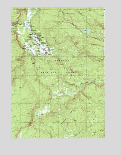
Old Faithful, WY USGS Topographic Map
Click on map above to begin viewing in our Map Viewer.

This topographic map contains these locations and features:
Feature Name Type Latitude Longitude GNIS ID View Map
Abuse SpringSpringN44.4585°W110.8349°1953433View Map
Anemone GeyserSpringN44.4625°W110.8289°1848494View Map
Artemisia GeyserSpringN44.4499°W110.8341°1597120View Map
Asta SpringSpringN44.4749°W110.8672°1848497View Map
Basin SpringSpringN44.4602°W110.8374°1953366View Map
Beauty PoolSpringN44.4685°W110.8388°1609397View Map
Beehive GeyserSpringN44.4630°W110.8299°1609398View Map
Belgian PoolSpringN44.4660°W110.8369°1829165View Map
Big Cub GeyserSpringN44.4666°W110.8341°1609412View Map
Bijou GeyserSpringN44.4713°W110.8405°1609399View Map
Biscuit BasinBasinN44.4833°W110.8538°1609227View Map
Biscuit Basin GeyserSpringN44.4816°W110.8505°1953378View Map
Black Sand Geyser BasinBasinN44.4633°W110.8472°1609228View Map
Black Sand PoolSpringN44.4666°W110.8508°1597132View Map
Blue Lemon SpringSpringN44.4580°W110.8360°1953364View Map
Bulger GeyserSpringN44.4658°W110.8372°1609381View Map
Cascade GroupSpringN44.4799°W110.8508°1794844View Map
Castle GeyserSpringN44.4638°W110.8341°1597119View Map
Cement HillsRangeN44.3764°W110.7586°1586518View Map
Chain Lake GroupSpringN44.4727°W110.8424°1953376View Map
Chimney ConeSpringN44.4833°W110.8372°1609378View Map
Chinaman SpringSpringN44.4419°W110.8313°1953434View Map
Chinese SpringSpringN44.4619°W110.8291°1597593View Map
Chromatic PoolSpringN44.4697°W110.8391°1609383View Map
Churn GeyserSpringN44.4658°W110.8369°1829164View Map
Cliff GeyserSpringN44.4619°W110.8541°1609414View Map
Crested PoolSpringN44.4638°W110.8366°1609385View Map
Cyclops SpringSpringN44.4744°W110.8458°1848519View Map
Daisy GeyserSpringN44.4699°W110.8449°1609377View Map
Daisy GroupSpringN44.4702°W110.8435°1953374View Map
Doublet PoolSpringN44.4635°W110.8305°1609384View Map
Ear SpringSpringN44.4638°W110.8308°1848526View Map
East Triplet GeyserSpringN44.4666°W110.8372°1829162View Map
Economic Geyser CraterSpringN44.4833°W110.8341°1609375View Map
Emerald PoolSpringN44.4613°W110.8566°1609248View Map
Fan GeyserSpringN44.4744°W110.8424°1609376View Map
Fern CascadesFallsN44.4460°W110.8441°1588425View Map
Fissure SpringSpringN44.4647°W110.8347°1953369View Map
Gem PoolSpringN44.4849°W110.8591°1597127View Map
Geyser HillSummitN44.4648°W110.8299°1953367View Map
Giant GeyserSpringN44.4708°W110.8408°1609413View Map
Giant GroupSpringN44.4705°W110.8408°1953375View Map
Giantess GeyserSpringN44.4749°W110.8369°1597123View Map
Grand GeyserSpringN44.4666°W110.8383°1597131View Map
Grand GroupSpringN44.4666°W110.8360°1953370View Map
Grants PassGapN44.3819°W110.8252°1589061View Map
Grotto GeyserSpringN44.4719°W110.8422°1609257View Map
Handkerchief PoolSpringN44.4638°W110.8535°1597128View Map
Hillside SpringsSpringN44.4755°W110.8677°1609263View Map
Inkwell SpringSpringN44.4749°W110.8466°1609342View Map
Iron Spring CreekStreamN44.4816°W110.8569°1589968View Map
Jewel GeyserSpringN44.4916°W110.8647°1597121View Map
Kepler CascadesFallsN44.4458°W110.8072°1590331View Map
Link GeyserSpringN44.4733°W110.8430°1829163View Map
Lion GeyserSpringN44.4666°W110.8341°1609391View Map
Lion GroupSpringN44.4635°W110.8310°1953368View Map
Lioness GeyserSpringN44.4666°W110.8341°1609390View Map
Little Cub GeyserSpringN44.4666°W110.8341°1609393View Map
Little Firehole RiverStreamN44.4847°W110.8530°1590797View Map
Lone Star GeyserSpringN44.4184°W110.8067°1609270View Map
Lone Star Geyser BasinSpringN44.4138°W110.8177°1794922View Map
Mallard LakeLakeN44.4778°W110.7760°1591188View Map
Mallard Lake TrailTrailN44.4683°W110.7847°1591189View Map
Mastiff GeyserSpringN44.4637°W110.8312°1609401View Map
Milk CauldronSpringN44.4674°W110.8394°1953371View Map
Mirror PoolSpringN44.4833°W110.8341°1609379View Map
Morning Glory PoolLakeN44.4749°W110.8438°1591761View Map
Morning Glory Pool GroupSpringN44.4749°W110.8438°1794860View Map
Mortar GeyserSpringN44.4833°W110.8341°1609380View Map
Mustard SpringsSpringN44.4833°W110.8508°1848559View Map
Myriad CreekStreamN44.4638°W110.8335°1609276View Map
Myriad GroupSpringN44.4588°W110.8369°1848560View Map
Myriad Group SpringsSpringN44.4588°W110.8177°1794846View Map
Mystic FallsFallsN44.4841°W110.8738°1609277View Map
North Triplet Geyser (historical)SpringN44.4666°W110.8372°1829161View Map
Oblong GeyserSpringN44.4691°W110.8402°1609403View Map
Old FaithfulLocaleN44.4597°W110.8324°1592387View Map
Old Faithful GeyserSpringN44.4605°W110.8288°1592386View Map
Old Faithful InnBuildingN44.4597°W110.8322°2040866View Map
Old Tardy GeyserSpringN44.4660°W110.8369°1829153View Map
Orange SpringSpringN44.4647°W110.8399°1953372View Map
Oval SpringSpringN44.4660°W110.8366°1829154View Map
Penta GeyserSpringN44.4658°W110.8366°1829155View Map
Percolator GeyserSpringN44.4669°W110.8372°1829156View Map
Pine SpringsSpringN44.4669°W110.8472°1592810View Map
Pump GeyserSpringN44.4639°W110.8294°1848575View Map
Punch Bowl SpringSpringN44.4749°W110.8577°1609339View Map
Rainbow PoolSpringN44.4708°W110.8591°1597129View Map
Rift GeyserSpringN44.4666°W110.8366°1829157View Map
Riverside GeyserSpringN44.4735°W110.8405°1953377View Map
Round SpringSpringN44.4688°W110.8427°1848582View Map
Round Spring GroupSpringN44.4688°W110.8427°1953373View Map
Rusty GeyserSpringN44.4844°W110.8522°1953435View Map
Sapphire PoolLakeN44.4852°W110.8555°1593942View Map
Sapphire Pool SpringSpringN44.4849°W110.8527°1794924View Map
Sawmill GeyserSpringN44.4652°W110.8369°1609400View Map
Scaup LakeLakeN44.4306°W110.7670°1593982View Map
Shell GeyserSpringN44.4847°W110.8566°1848586View Map
Silver GlobeSpringN44.4833°W110.8508°1609340View Map
Sinter PlainFlatN44.4749°W110.8627°1594376View Map
Solitary GeyserSpringN44.4688°W110.8285°1597122View Map
South Eastern Group SpringsSpringN44.4588°W110.8177°1794848View Map
Spasmodic GeyserSpringN44.4655°W110.8360°1609392View Map
Sponge GeyserSpringN44.4635°W110.8294°1609402View Map
Spouter GeyserSpringN44.4666°W110.8674°1597134View Map
Spring CreekStreamN44.4255°W110.7972°1594882View Map
Sunset LakeLakeN44.4708°W110.8591°1609341View Map
Teakettle SpringSpringN44.4705°W110.8413°1609386View Map
Teal LakeLakeN44.4605°W110.7538°1596957View Map
Three Sisters SpringsSpringN44.4602°W110.8299°1609387View Map
Tortoise Shell SpringSpringN44.4638°W110.8377°1848605View Map
Turban GeyserSpringN44.4666°W110.8341°1609388View Map
Uncertain GeyserSpringN44.4655°W110.8369°1829158View Map
Upper Geyser BasinBasinN44.4644°W110.8291°1595862View Map
Vent GeyserSpringN44.4669°W110.8372°1829159View Map
West Fork Iron Spring CreekStreamN44.4613°W110.8552°1596199View Map
West Trail GeyserSpringN44.4591°W110.8366°1953365View Map
West Triplet GeyserSpringN44.4666°W110.8372°1829160View Map
Yellowstone National Park Fire Department Old Faithful StationBuildingN44.4543°W110.8366°2673534View Map

Note: Coordinates in the location and feature list above are referenced to NAD83 datum.


Copyright (C) 2008-2024 Ryan Niemi / Sunset Dynamics ... All Rights Reserved