TopoQuest Logo
Do you find TopoQuest useful?
Help keep TopoQuest running and adding new maps/features by donating!
Bitcoin:  19c7KJd3qBynnjoSw5npx9KScwjBe4ifkT
Litecoin:  LXs6TkuXGGXo1vDsWCkWVdjQX94eUKd6ui
Home View Maps Find Maps Find Places Resources & Links


Olamon, Maine Topographic Map

USGS Map Title: Olamon, ME
USGS Map MRC: 45068A5
DRG (GeoTIFF) Download: o45068a5.tif


Neighboring USGS Topographic Map Quads:


  Howland, ME  
45068B6
 

  Passadumkeag, ME  
45068B5
 

  Burlington, ME  
45068B4
 

  Greenbush, ME  
45068A6
 

  Olamon, ME  
45068A5
 

  Greenfield, ME  
45068A4
 

  Old Town, ME  
44068H6
 

  Otter Chain Ponds, ME  
44068H5
 

  The Horseback, ME  
44068H4


Map MRC Location:

N46°
W69°
N46°
W68°
H8 H7 H6 H5 H4 H3 H2 H1
G8 G7 G6 G5 G4 G3 G2 G1
F8 F7 F6 F5 F4 F3 F2 F1
E8 E7 E6 E5 E4 E3 E2 E1
D8 D7 D6 D5 D4 D3 D2 D1
C8 C7 C6 C5 C4 C3 C2 C1
B8 B7 B6 B5 B4 B3 B2 B1
A8 A7 A6 A5 A4 A3 A2 A1
N45°
W69°
N45°
W68°

Olamon, ME USGS 1:24K Topographic Map Preview:
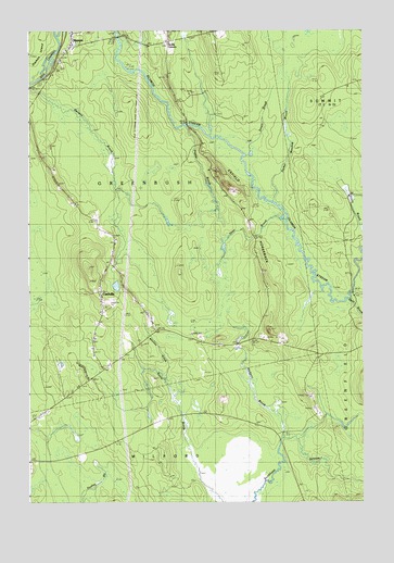
Olamon, ME USGS Topographic Map
Click on map above to begin viewing in our Map Viewer.

This topographic map contains these locations and features:
Feature Name Type Latitude Longitude GNIS ID View Map
Bear BrookStreamN45.0537°W68.5050°561817View Map
CardvillePopulated PlaceN45.0559°W68.5989°579175View Map
Cardville CemeteryCemeteryN45.0468°W68.5779°563506View Map
Cardville ChurchChurchN45.0709°W68.5950°563507View Map
Dennis CemeteryCemeteryN45.1149°W68.6144°565040View Map
Enfield HorsebackRidgeN45.1115°W68.5739°565919View Map
Fulton Bridge (historical)BridgeN45.1234°W68.5934°566651View Map
Greenbush Volunteer Fire Department Codville StationBuildingN45.0404°W68.5858°2553069View Map
Greenbush Volunteer Fire Department Oloman StationBuildingN45.1208°W68.6092°2553109View Map
Halfway BrookStreamN45.0167°W68.5306°567477View Map
Helen Dunn Elementary SchoolSchoolN45.1200°W68.6083°577251View Map
OlamonPopulated PlaceN45.1209°W68.6106°572676View Map
Olamon IslandIslandN45.1201°W68.6242°572678View Map
Olamon Post OfficePost OfficeN45.1245°W68.6078°1913766View Map
Otter BrookStreamN45.0748°W68.5295°572801View Map
Parker Meadow BrookStreamN45.0795°W68.5342°572984View Map
Poplar BrookStreamN45.0987°W68.5697°573636View Map
Scotts CornersLocaleN45.1217°W68.5739°575057View Map
Side ChannelChannelN45.1131°W68.6206°575449View Map
Smart BrookStreamN45.0917°W68.5436°575574View Map
Spring Bridge (historical)BridgeN45.1001°W68.5661°576085View Map
Town of GreenbushCivilN45.0793°W68.5878°582499View Map
United Pentecostal ChurchChurchN45.0531°W68.5856°1913948View Map
Welles CemeteryCemeteryN45.1179°W68.6122°577990View Map
Whitney BrookStreamN45.0328°W68.5742°578410View Map

Note: Coordinates in the location and feature list above are referenced to NAD83 datum.


Copyright (C) 2008-2024 Ryan Niemi / Sunset Dynamics ... All Rights Reserved