TopoQuest Logo
Do you find TopoQuest useful?
Help keep TopoQuest running and adding new maps/features by donating!
Bitcoin:  19c7KJd3qBynnjoSw5npx9KScwjBe4ifkT
Litecoin:  LXs6TkuXGGXo1vDsWCkWVdjQX94eUKd6ui
Home View Maps Find Maps Find Places Resources & Links


Ogden, Arkansas Topographic Map

USGS Map Title: Ogden, AR
USGS Map MRC: 33094E1
DRG (GeoTIFF) Download: o33094e1.tif


Neighboring USGS Topographic Map Quads:


  Ashdown West, AR  
33094F2
 

  Ashdown East, AR  
33094F1
 

  Red Bluff, AR  
33093F8
 

  Barkman, TX  
33094E2
 

  Ogden, AR  
33094E1
 

  Homan, AR  
33093E8
 

  Leary, TX  
33094D2
 

  Texarkana, TX  
33094D1
 

  Mandeville, AR  
33093D8


Map MRC Location:

N34°
W95°
N34°
W94°
H8 H7 H6 H5 H4 H3 H2 H1
G8 G7 G6 G5 G4 G3 G2 G1
F8 F7 F6 F5 F4 F3 F2 F1
E8 E7 E6 E5 E4 E3 E2 E1
D8 D7 D6 D5 D4 D3 D2 D1
C8 C7 C6 C5 C4 C3 C2 C1
B8 B7 B6 B5 B4 B3 B2 B1
A8 A7 A6 A5 A4 A3 A2 A1
N33°
W95°
N33°
W94°

Ogden, AR USGS 1:24K Topographic Map Preview:
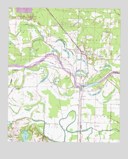
Ogden, AR USGS Topographic Map
Click on map above to begin viewing in our Map Viewer.

This topographic map contains these locations and features:
Feature Name Type Latitude Longitude GNIS ID View Map
Bringle LakeReservoirN33.5031°W94.1050°1352895View Map
Bringle Lake DamDamN33.5101°W94.1035°1854955View Map
Brushy LakeSwampN33.5943°W94.0652°47085View Map
City of OgdenCivilN33.5842°W94.0447°2404422View Map
Clear CreekStreamN33.5143°W94.0846°1354624View Map
Clear Lake SchoolSchoolN33.5501°W94.1169°1354642View Map
Cut-off LakeLakeN33.5856°W94.0961°75688View Map
East Ogden Volunteer Fire DepartmentBuildingN33.5820°W94.0299°2116386View Map
East Ogden Volunteer Fire DepartmentBuildingN33.5855°W94.0255°2116387View Map
First Baptist Church of OgdenChurchN33.5862°W94.0480°60100View Map
First LakeLakeN33.5748°W94.0398°75709View Map
Fish LakeLakeN33.6012°W94.0894°75710View Map
Flying W AirportAirportN33.5122°W94.0155°83844View Map
Haney CreekStreamN33.5943°W94.0860°77114View Map
IndexPopulated PlaceN33.5471°W94.0419°57966View Map
Index BridgeBridgeN33.5523°W94.0416°60128View Map
KTFS-FM (Ashdown)TowerN33.6018°W94.0774°85359View Map
McKinney BayouStreamN33.5687°W94.1060°1362498View Map
Mill BranchStreamN33.5596°W94.0194°51967View Map
Mill LakeLakeN33.5836°W94.0599°75789View Map
Nacoosa Paper Retention Pond LeveeDamN33.6201°W94.0985°81087View Map
New Zion ChurchChurchN33.5179°W94.0830°1363836View Map
Oak Grove SchoolSchoolN33.5065°W94.1182°1364282View Map
OgdenPopulated PlaceN33.5826°W94.0427°58297View Map
Ogden Post OfficePost OfficeN33.5850°W94.0487°83906View Map
Ogden Volunteer Fire DepartmentBuildingN33.5843°W94.0488°2116896View Map
Pine Prairie Airport (historical)AirportN33.6168°W94.1169°83628View Map
Pleasant Grove Volunteer Fire DepartmentBuildingN33.5065°W94.1185°2655646View Map
Pleasant LakeLakeN33.5629°W94.0476°75824View Map
Red BranchStreamN33.5787°W94.0682°53936View Map
Red LakeLakeN33.5854°W94.0735°75829View Map
Rosenwald SchoolSchoolN33.5798°W94.0221°54212View Map
Saint Johns ChurchChurchN33.5435°W94.0432°54361View Map
Summer Hill LakeLakeN33.5579°W94.0859°1369384View Map
Thompson SubdivisionPopulated PlaceN33.5843°W94.0313°60181View Map
Washington SchoolSchoolN33.6032°W94.0163°56079View Map
Winham LakeLakeN33.5449°W94.0279°75895View Map

Note: Coordinates in the location and feature list above are referenced to NAD83 datum.


Copyright (C) 2008-2024 Ryan Niemi / Sunset Dynamics ... All Rights Reserved