TopoQuest Logo
Do you find TopoQuest useful?
Help keep TopoQuest running and adding new maps/features by donating!
Bitcoin:  19c7KJd3qBynnjoSw5npx9KScwjBe4ifkT
Litecoin:  LXs6TkuXGGXo1vDsWCkWVdjQX94eUKd6ui
Home View Maps Find Maps Find Places Resources & Links


Ocean Park, Washington Topographic Map

USGS Map Title: Ocean Park, WA
USGS Map MRC: 46124D1
DRG (GeoTIFF) Download: o46124d1.tif


Neighboring USGS Topographic Map Quads:


  Oysterville, WA  
46124E1
 

  Nemah, WA  
46123E8


  Ocean Park, WA  
46124D1
 

  Long Island, WA  
46123D8


  Cape Disappointment, WA  
46124C1
 

  Chinook, WA  
46123C8


Map MRC Location:

N47°
W125°
N47°
W124°
H8 H7 H6 H5 H4 H3 H2 H1
G8 G7 G6 G5 G4 G3 G2 G1
F8 F7 F6 F5 F4 F3 F2 F1
E8 E7 E6 E5 E4 E3 E2 E1
D8 D7 D6 D5 D4 D3 D2 D1
C8 C7 C6 C5 C4 C3 C2 C1
B8 B7 B6 B5 B4 B3 B2 B1
A8 A7 A6 A5 A4 A3 A2 A1
N46°
W125°
N46°
W124°

Ocean Park, WA USGS 1:24K Topographic Map Preview:
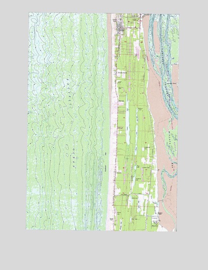
Ocean Park, WA USGS Topographic Map
Click on map above to begin viewing in our Map Viewer.

This topographic map contains these locations and features:
Feature Name Type Latitude Longitude GNIS ID View Map
Adamson RanchLocaleN46.3801°W124.0165°1502939View Map
Albers SloughStreamN46.3909°W124.0171°1502959View Map
Anchor Baptist MissionChurchN46.4239°W124.0516°2609597View Map
Andersens Recreational Vehicle ParkLocaleN46.4022°W124.0562°2608244View Map
Breaker LakeLakeN46.3797°W124.0471°1503536View Map
Briscoe LakeLakeN46.3834°W124.0515°1503552View Map
Clam LakeLakeN46.3938°W124.0391°1503988View Map
Cranberry LakeLakeN46.4042°W124.0369°1504248View Map
Cranberry MarshSwampN46.3818°W124.0199°1504251View Map
Deer LakeLakeN46.3815°W124.0392°1504416View Map
Family Worship CenterChurchN46.4935°W124.0487°2609040View Map
Freshwater LakeLakeN46.4219°W124.0297°1505047View Map
Gile LakeLakeN46.3905°W124.0327°1505133View Map
Giles SloughStreamN46.3923°W124.0163°1505135View Map
Island LakeLakeN46.4272°W124.0355°1505758View Map
Jensen PointCapeN46.4590°W124.0015°1505805View Map
Kingdom Hall of Jehovahs WitnessesChurchN46.3803°W124.0524°2609598View Map
Klipsan BeachPopulated PlaceN46.4665°W124.0529°1512356View Map
Klipsan Meadows ParkPopulated PlaceN46.4671°W124.0440°2607407View Map
Litschke LakeLakeN46.4077°W124.0301°1506182View Map
Long Beach-North Beach Peninsula DivisionCivilN46.4891°W124.0656°1939597View Map
LoomisPopulated PlaceN46.4362°W124.0482°1514872View Map
Loomis LakeLakeN46.4373°W124.0430°1506308View Map
Loomis Lake State ParkParkN46.4343°W124.0540°1509894View Map
Loomis RanchLocaleN46.4607°W124.0516°1506309View Map
Lost LakeLakeN46.4395°W124.0351°1506322View Map
Ma and Pas Mobile Home ParkPopulated PlaceN46.3792°W124.0550°2607326View Map
Mallard LakeLakeN46.4442°W124.0352°1506437View Map
Moby Dick AcademySchoolN46.4895°W124.0374°1515137View Map
NahcottaPopulated PlaceN46.4984°W124.0335°1506923View Map
Nahcotta ChannelChannelN46.4665°W124.0138°1506924View Map
New Hope Baptist ChurchChurchN46.4769°W124.0452°2609722View Map
North Beach PeninsulaCapeN46.4998°W124.0346°1507018View Map
Ocean Bay Mobile Home ParkPopulated PlaceN46.4921°W124.0396°2607408View Map
Ocean ParkPopulated PlaceN46.4915°W124.0502°1512524View Map
Ocean Park Census Designated PlaceCensusN46.4962°W124.0437°2408973View Map
Ocean Park Community ChurchChurchN46.4964°W124.0504°2609723View Map
Ocean Park Elementary SchoolSchoolN46.4884°W124.0504°1531045View Map
Ocean Park Lutheran ChurchChurchN46.4757°W124.0435°2609724View Map
Ocean Park Post OfficePost OfficeN46.4874°W124.0497°2606994View Map
Ocean Park Timberland LibraryBuildingN46.4876°W124.0517°2610212View Map
Ocean Park United Methodist ChurchChurchN46.4922°W124.0528°2609725View Map
OceansidePopulated PlaceN46.4084°W124.0524°1512526View Map
Pacific BeachLocaleN46.3954°W124.0540°1512982View Map
Pacific County Fire District 1BuildingN46.4195°W124.0515°2619736View Map
Pacific County Fire District 1BuildingN46.4104°W124.0228°2619737View Map
Pacific County Fire District 1 Station 1BuildingN46.4920°W124.0493°2606742View Map
Pacific County Fire District 1 Station 1 AnnexBuildingN46.4929°W124.0470°2619757View Map
Pacific ParkLocaleN46.3790°W124.0532°1507251View Map
Pacific West Mobile Home ParkPopulated PlaceN46.3900°W124.0562°2607327View Map
Pauls LakeLakeN46.4778°W124.0353°1507335View Map
Pauls SloughStreamN46.4918°W124.0316°1507336View Map
Pegs Recreational Vehicle ParkLocaleN46.4130°W124.0553°2608245View Map
Peninsula Assembly of God ChurchChurchN46.4935°W124.0487°2609726View Map
Peninsula Baptist ChurchChurchN46.4752°W124.0516°2609727View Map
Raine RanchLocaleN46.3782°W124.0218°1507706View Map
Rasmason RanchLocaleN46.3848°W124.0171°1507721View Map
Riiho ParkLocaleN46.4468°W124.0510°1507805View Map
Shoalwater BayBayN46.4045°W124.0046°1508316View Map
Tape LakeLakeN46.4114°W124.0361°1508913View Map
Wreckage Park ZooParkN46.4965°W124.0404°1509637View Map

Note: Coordinates in the location and feature list above are referenced to NAD83 datum.


Copyright (C) 2008-2024 Ryan Niemi / Sunset Dynamics ... All Rights Reserved