TopoQuest Logo
Do you find TopoQuest useful?
Help keep TopoQuest running and adding new maps/features by donating!
Bitcoin:  19c7KJd3qBynnjoSw5npx9KScwjBe4ifkT
Litecoin:  LXs6TkuXGGXo1vDsWCkWVdjQX94eUKd6ui
Home View Maps Find Maps Find Places Resources & Links


Northeast Pueblo, Colorado Topographic Map

USGS Map Title: Northeast Pueblo, CO
USGS Map MRC: 38104C5
DRG (GeoTIFF) Download: o38104c5.tif


Neighboring USGS Topographic Map Quads:


  Steele Hollow, CO  
38104D6
 

  Pinon, CO  
38104D5
 

  Bar J H Ranch, CO  
38104D4
 

  Northwest Pueblo, CO  
38104C6
 

  Northeast Pueblo, CO  
38104C5
 

  Devine, CO  
38104C4
 

  Southwest Pueblo, CO  
38104B6
 

  Southeast Pueblo, CO  
38104B5
 

  Vineland, CO  
38104B4


Map MRC Location:

N39°
W105°
N39°
W104°
H8 H7 H6 H5 H4 H3 H2 H1
G8 G7 G6 G5 G4 G3 G2 G1
F8 F7 F6 F5 F4 F3 F2 F1
E8 E7 E6 E5 E4 E3 E2 E1
D8 D7 D6 D5 D4 D3 D2 D1
C8 C7 C6 C5 C4 C3 C2 C1
B8 B7 B6 B5 B4 B3 B2 B1
A8 A7 A6 A5 A4 A3 A2 A1
N38°
W105°
N38°
W104°

Northeast Pueblo, CO USGS 1:24K Topographic Map Preview:
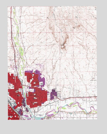
Northeast Pueblo, CO USGS Topographic Map
Click on map above to begin viewing in our Map Viewer.

This topographic map contains these locations and features:
Feature Name Type Latitude Longitude GNIS ID View Map
American Medical Response PuebloBuildingN38.2511°W104.6060°2695583View Map
Ascension Episcopal Church ColumbariumCemeteryN38.2833°W104.6121°2750936View Map
B'Nai Jacob CemeteryCemeteryN38.2893°W104.6214°2750937View Map
Belmont Post OfficePost OfficeN38.2870°W104.5943°2750980View Map
Benjamin Franklin SchoolSchoolN38.2911°W104.5708°193733View Map
Big HillSummitN38.2875°W104.6233°193727View Map
Booth CanalCanalN38.2722°W104.5394°203689View Map
Bradford Elementary SchoolSchoolN38.2677°W104.5893°193738View Map
Bradford ParkParkN38.2689°W104.5866°193737View Map
Centennial StadiumParkN38.2764°W104.6053°193732View Map
Children's Hospital Colorado Therapy Care PuebloBuildingN38.3113°W104.6170°2695668View Map
Christ the King ChurchChurchN38.2947°W104.5914°193724View Map
City of PuebloCivilN38.2702°W104.6130°2411501View Map
Colorado State Patrol District 2BuildingN38.2770°W104.6003°2696675View Map
Colorado State Patrol Troop 2D PuebloBuildingN38.2757°W104.5995°2696674View Map
Colorado State University PuebloSchoolN38.3085°W104.5767°193726View Map
Crome ParkParkN38.2614°W104.6214°193740View Map
East High SchoolSchoolN38.2900°W104.5775°193747View Map
EdenPopulated PlaceN38.3164°W104.6164°193722View Map
Eva R Baca Elementary SchoolSchoolN38.2834°W104.5603°193748View Map
FearnowvillePopulated PlaceN38.2792°W104.5603°193749View Map
Fountain CreekStreamN38.2542°W104.5889°193719View Map
Freed Middle SchoolSchoolN38.2864°W104.6181°193730View Map
Gnat HollowValleyN38.3614°W104.6170°193699View Map
Goat HillSummitN38.2694°W104.6039°193739View Map
Heaton Middle SchoolSchoolN38.3028°W104.5875°193725View Map
Henkle ParkParkN38.2569°W104.6164°193746View Map
Jacob Fowlers LookoutLocaleN38.2639°W104.5900°196554View Map
KERP-FM (Pueblo)TowerN38.3731°W104.5622°204188View Map
KOAA-TV (Pueblo)TowerN38.3736°W104.5580°204236View Map
KRRU-AM (Pueblo)TowerN38.3156°W104.6180°204057View Map
KTSC-FM (Pueblo)TowerN38.3106°W104.5783°204187View Map
KTSC-TV (Pueblo)TowerN38.3736°W104.5580°204234View Map
Masonic CemeteryCemeteryN38.2878°W104.6205°193728View Map
Midtown Post OfficePost OfficeN38.2725°W104.6211°2750982View Map
Mineral Palace ParkParkN38.2825°W104.6083°193731View Map
Mitchell ParkParkN38.2778°W104.5880°193734View Map
North Mills Clarifying PondReservoirN38.2503°W104.5954°200511View Map
Nussbaum SpringSpringN38.3319°W104.5500°193721View Map
Parkview Medical CenterHospitalN38.2817°W104.6126°193729View Map
Parkview Medical Center HeliportAirportN38.2808°W104.6144°204558View Map
Parkview SchoolSchoolN38.2764°W104.5878°193735View Map
Pleasant View Middle SchoolSchoolN38.2519°W104.5494°193792View Map
Porter CreekStreamN38.3722°W104.6150°193895View Map
PuebloPopulated PlaceN38.2544°W104.6091°204798View Map
Pueblo County Sheriff's OfficeBuildingN38.2756°W104.6106°2696606View Map
Pueblo County Sheriff's Office at Colorado State University PuebloBuildingN38.3085°W104.5769°2696676View Map
Pueblo DamDamN38.3000°W104.6005°198730View Map
Pueblo Fire Department Station 1BuildingN38.2736°W104.6127°2667202View Map
Pueblo Fire Department Station 3BuildingN38.2597°W104.6233°2667205View Map
Pueblo Fire Department Station 5BuildingN38.2913°W104.6230°2667201View Map
Pueblo Fire Department Station 6BuildingN38.2714°W104.5879°2667203View Map
Pueblo Fire Department Station 8BuildingN38.2921°W104.5926°2666885View Map
Pueblo High SchoolSchoolN38.2542°W104.6205°193743View Map
Pueblo Police DepartmentBuildingN38.2631°W104.6128°2696611View Map
Pueblo Post OfficePost OfficeN38.3120°W104.6199°2750981View Map
Risley Middle SchoolSchoolN38.2732°W104.5873°193736View Map
Royal ParkParkN38.2594°W104.6205°196379View Map
Runyan FieldParkN38.2564°W104.6019°193745View Map
Salt CreekStreamN38.2519°W104.5758°193777View Map
Smelter HillSummitN38.2611°W104.6005°193741View Map
Somerlid Elementary SchoolSchoolN38.2958°W104.6170°193723View Map
South Colorado Power Company DamDamN38.2683°W104.6189°201498View Map
South Colorado Power Company ReservoirReservoirN38.2683°W104.6189°201499View Map
Strack SchoolSchoolN38.2514°W104.6130°193744View Map
US Marshals Service Pueblo OfficeBuildingN38.2740°W104.6084°2696677View Map

Note: Coordinates in the location and feature list above are referenced to NAD83 datum.


Copyright (C) 2008-2024 Ryan Niemi / Sunset Dynamics ... All Rights Reserved