TopoQuest Logo
Do you find TopoQuest useful?
Help keep TopoQuest running and adding new maps/features by donating!
Bitcoin:  19c7KJd3qBynnjoSw5npx9KScwjBe4ifkT
Litecoin:  LXs6TkuXGGXo1vDsWCkWVdjQX94eUKd6ui
Home View Maps Find Maps Find Places Resources & Links


North Bay, Virginia Topographic Map

USGS Map Title: North Bay, VA
USGS Map MRC: 36075F8
DRG (GeoTIFF) Download: o36075f8.tif


Neighboring USGS Topographic Map Quads:


  Princess Anne, VA  
36076G1
 

  Virginia Beach, VA  
36075G8


  Pleasant Ridge, VA  
36076F1
 

  North Bay, VA  
36075F8


  Creeds, VA  
36076E1
 

  Knotts Island, NC  
36075E8


Map MRC Location:

N37°
W76°
N37°
W75°
H8 H7 H6 H5 H4 H3 H2 H1
G8 G7 G6 G5 G4 G3 G2 G1
F8 F7 F6 F5 F4 F3 F2 F1
E8 E7 E6 E5 E4 E3 E2 E1
D8 D7 D6 D5 D4 D3 D2 D1
C8 C7 C6 C5 C4 C3 C2 C1
B8 B7 B6 B5 B4 B3 B2 B1
A8 A7 A6 A5 A4 A3 A2 A1
N36°
W76°
N36°
W75°

North Bay, VA USGS 1:24K Topographic Map Preview:
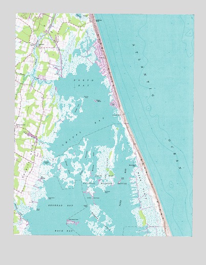
North Bay, VA USGS Topographic Map
Click on map above to begin viewing in our Map Viewer.

This topographic map contains these locations and features:
Feature Name Type Latitude Longitude GNIS ID View Map
Ashville Bridge CreekStreamN36.7143°W75.9863°1478114View Map
Back Bay Game Refuge Camp (historical)LocaleN36.6724°W75.9155°1780191View Map
Back Bay National Wildlife RefugeParkN36.6518°W75.9093°1478122View Map
Beggars Bridge CreekStreamN36.6754°W75.9733°1478170View Map
Big BendBayN36.7188°W75.9527°1780194View Map
Bonney CoveBayN36.6671°W75.9433°1478244View Map
Bread IslandIslandN36.6890°W75.9308°1780196View Map
Bridge CoveBayN36.6971°W75.9558°1478263View Map
Bush Island CoveBayN36.6640°W75.9171°1478296View Map
Charity NeckCapeN36.6682°W75.9885°1478365View Map
Charity United Methodist ChurchChurchN36.6724°W75.9999°1478364View Map
Drum PointCapeN36.6388°W75.9844°1478504View Map
East Big Bend PointCapeN36.7171°W75.9491°1780198View Map
Emmanuel Christian Church of GodChurchN36.6967°W75.9981°2520281View Map
Gall Bush PointCapeN36.6496°W75.9369°1478635View Map
Great CoveBayN36.6632°W75.9610°1478686View Map
Great NarrowsGutN36.6668°W75.9524°1478688View Map
Heaven PointCapeN36.6415°W75.9477°1478737View Map
Hell Point CreekGutN36.7265°W75.9674°1478741View Map
Hells Point Golf CourseLocaleN36.7404°W75.9774°1780201View Map
Hill LandingPopulated PlaceN36.6565°W75.9810°1496943View Map
Landing CoveBayN36.6657°W75.9769°1478921View Map
Little NarrowsGutN36.6463°W75.9446°1484942View Map
Long IslandIslandN36.6627°W75.9346°1478990View Map
Mose Island PointCapeN36.6452°W75.9760°1479131View Map
Muddy CreekStreamN36.7118°W75.9722°1479171View Map
Nawney CreekStreamN36.6352°W75.9927°1479188View Map
North BayBayN36.7110°W75.9521°1479214View Map
Porpoise PointCapeN36.7024°W75.9508°1479366View Map
Ragged IslandIslandN36.6285°W75.9399°1479576View Map
Redhead BayBayN36.6415°W75.9644°1479409View Map
Rock Island HaulIslandN36.6324°W75.9588°1479458View Map
Sand BayBayN36.6518°W75.9235°1479541View Map
Sand BendBayN36.7196°W75.9441°1780211View Map
Sandbridge BeachPopulated PlaceN36.7460°W75.9441°1497129View Map
Sandbridge MarshSwampN36.7269°W75.9519°1780212View Map
Sandbridge United Methodist ChurchChurchN36.7229°W75.9363°2056790View Map
Sandbridge Volunteer Rescue SquadBuildingN36.7456°W75.9458°2660597View Map
Shell IslandIslandN36.6554°W75.9255°1780213View Map
Shell PointCapeN36.6563°W75.9249°1479603View Map
Shipps BayBayN36.6860°W75.9488°1479614View Map
SigmaPopulated PlaceN36.7318°W75.9860°1497153View Map
Stinger MarshSwampN36.7010°W75.9434°1479677View Map
Tabernacle United Methodist ChurchChurchN36.7315°W75.9827°1479706View Map
Virginia Beach Fire Department Station 17 SandbridgeBuildingN36.7455°W75.9456°2056789View Map
Wash FlatsFlatN36.6535°W75.9099°1479827View Map
West Big Bend PointCapeN36.7135°W75.9655°1780215View Map

Note: Coordinates in the location and feature list above are referenced to NAD83 datum.


Copyright (C) 2008-2024 Ryan Niemi / Sunset Dynamics ... All Rights Reserved