TopoQuest Logo
Do you find TopoQuest useful?
Help keep TopoQuest running and adding new maps/features by donating!
Bitcoin:  19c7KJd3qBynnjoSw5npx9KScwjBe4ifkT
Litecoin:  LXs6TkuXGGXo1vDsWCkWVdjQX94eUKd6ui
Home View Maps Find Maps Find Places Resources & Links


Norfleet, North Carolina Topographic Map

USGS Map Title: Norfleet, NC
USGS Map MRC: 36077B3
DRG (GeoTIFF) Download: o36077b3.tif


Neighboring USGS Topographic Map Quads:


  Boones Crossroads, NC  
36077C4
 

  Rich Square, NC  
36077C3
 

  Woodland, NC  
36077C2
 

  Scotland Neck, NC  
36077B4
 

  Norfleet, NC  
36077B3
 

  Kelford, NC  
36077B2
 

  Hobgood, NC  
36077A4
 

  Palmyra, NC  
36077A3
 

  Lewiston Woodville, NC  
36077A2


Map MRC Location:

N37°
W78°
N37°
W77°
H8 H7 H6 H5 H4 H3 H2 H1
G8 G7 G6 G5 G4 G3 G2 G1
F8 F7 F6 F5 F4 F3 F2 F1
E8 E7 E6 E5 E4 E3 E2 E1
D8 D7 D6 D5 D4 D3 D2 D1
C8 C7 C6 C5 C4 C3 C2 C1
B8 B7 B6 B5 B4 B3 B2 B1
A8 A7 A6 A5 A4 A3 A2 A1
N36°
W78°
N36°
W77°

Norfleet, NC USGS 1:24K Topographic Map Preview:
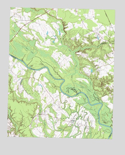
Norfleet, NC USGS Topographic Map
Click on map above to begin viewing in our Map Viewer.

This topographic map contains these locations and features:
Feature Name Type Latitude Longitude GNIS ID View Map
Barden CemeteryCemeteryN36.2076°W77.2527°980546View Map
Bell CemeteryCemeteryN36.2310°W77.2730°980934View Map
Brittons CreekStreamN36.1371°W77.2525°1025972View Map
Bull Neck SwampStreamN36.2074°W77.2986°982212View Map
Cypress SwampSwampN36.2085°W77.3502°983907View Map
Dynamite LakeReservoirN36.2227°W77.2693°984462View Map
Eason Island LandingLocaleN36.1260°W77.2525°1006453View Map
Fox BarkSummitN36.1888°W77.2891°1020342View Map
George HoleLakeN36.1931°W77.3494°985627View Map
Hall CemeteryCemeteryN36.1496°W77.3241°986311View Map
NorfleetPopulated PlaceN36.1421°W77.2986°1006315View Map
Norfleet CemeteryCemeteryN36.1904°W77.2677°991176View Map
Norfleets Ferry Site (historical)LocaleN36.1602°W77.2775°1006429View Map
Quinine SwampSwampN36.1729°W77.2739°992955View Map
Rea CemeteriesCemeteryN36.2424°W77.2764°993086View Map
Saint Stevens ChurchChurchN36.1404°W77.2961°994143View Map
Sandy RunStreamN36.1699°W77.2886°994328View Map
Sandy Run ChurchChurchN36.2168°W77.2533°994331View Map
Shields CommissaryLocaleN36.1474°W77.3391°1023552View Map
Turners PondReservoirN36.2267°W77.3152°1000379View Map
Turners Pond DamDamN36.2252°W77.3147°1000380View Map
Ventosa Plantation AirportAirportN36.1356°W77.2923°998033View Map
William ChapelChurchN36.1440°W77.3447°997353View Map
Woods LandingLocaleN36.1585°W77.2616°1006417View Map

Note: Coordinates in the location and feature list above are referenced to NAD83 datum.


Copyright (C) 2008-2024 Ryan Niemi / Sunset Dynamics ... All Rights Reserved