TopoQuest Logo
Do you find TopoQuest useful?
Help keep TopoQuest running and adding new maps/features by donating!
Bitcoin:  19c7KJd3qBynnjoSw5npx9KScwjBe4ifkT
Litecoin:  LXs6TkuXGGXo1vDsWCkWVdjQX94eUKd6ui
Home View Maps Find Maps Find Places Resources & Links


Nolin Lake, Kentucky Topographic Map

USGS Map Title: Nolin Lake, KY
USGS Map MRC: 37086C2
DRG (GeoTIFF) Download: o37086c2.tif


Neighboring USGS Topographic Map Quads:


  Leitchfield, KY  
37086D3
 

  Clarkson, KY  
37086D2
 

  Millerstown, KY  
37086D1
 

  Bee Spring, KY  
37086C3
 

  Nolin Lake, KY  
37086C2
 

  Cub Run, KY  
37086C1
 

  Brownsville, KY  
37086B3
 

  Rhoda, KY  
37086B2
 

  Mammoth Cave, KY  
37086B1


Map MRC Location:

N38°
W87°
N38°
W86°
H8 H7 H6 H5 H4 H3 H2 H1
G8 G7 G6 G5 G4 G3 G2 G1
F8 F7 F6 F5 F4 F3 F2 F1
E8 E7 E6 E5 E4 E3 E2 E1
D8 D7 D6 D5 D4 D3 D2 D1
C8 C7 C6 C5 C4 C3 C2 C1
B8 B7 B6 B5 B4 B3 B2 B1
A8 A7 A6 A5 A4 A3 A2 A1
N37°
W87°
N37°
W86°

Nolin Lake, KY USGS 1:24K Topographic Map Preview:
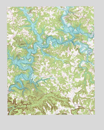
Nolin Lake, KY USGS Topographic Map
Click on map above to begin viewing in our Map Viewer.

This topographic map contains these locations and features:
Feature Name Type Latitude Longitude GNIS ID View Map
AnnetaPopulated PlaceN37.3709°W86.2453°507402View Map
Anneta Fire DepartmentBuildingN37.3463°W86.2398°2636717View Map
Brier CreekStreamN37.2917°W86.2180°487896View Map
Bylew CreekStreamN37.2570°W86.2397°488558View Map
Cane Camp BranchStreamN37.3256°W86.2197°488767View Map
Chimney StackPillarN37.2637°W86.2153°489480View Map
ConolowayPopulated PlaceN37.3681°W86.2155°507747View Map
Conoloway CreekStreamN37.3353°W86.2022°489979View Map
Cove HollowValleyN37.2619°W86.2121°490161View Map
Cove Hollow CemeteryCemeteryN37.2659°W86.2230°490163View Map
Cove Hollow ChurchChurchN37.2698°W86.2216°490164View Map
Cub RunPopulated PlaceN37.3228°W86.1947°507790View Map
Cubby CoveValleyN37.2549°W86.2442°490459View Map
Davis CreekStreamN37.3117°W86.2366°490664View Map
Demunbruns StorePopulated PlaceN37.2603°W86.1536°490809View Map
Dickeys Mills (historical)LocaleN37.3292°W86.2005°1782002View Map
Dismal RockSummitN37.2726°W86.2486°490907View Map
Dog CreekStreamN37.3353°W86.1572°490975View Map
DogcreekPopulated PlaceN37.3206°W86.1252°507861View Map
Dug HillPopulated PlaceN37.3531°W86.1486°507882View Map
Dug HillSummitN37.3622°W86.1398°491262View Map
Hill Grove Missionary Baptist ChurchChurchN37.3167°W86.2044°2571207View Map
Hill Grove Missionary Baptist Church CemeteryCemeteryN37.3169°W86.2038°2571208View Map
HillviewPopulated PlaceN37.2992°W86.2286°508246View Map
IberiaPopulated PlaceN37.3731°W86.1661°508304View Map
Jones BranchStreamN37.2606°W86.2164°495454View Map
Lakeview AirportAirportN37.3255°W86.1552°2770368View Map
Laurel Ridge CampLocaleN37.2842°W86.2083°496059View Map
Lincoln SchoolSchoolN37.2567°W86.1533°496558View Map
Lincoln Volunteer Fire DepartmentBuildingN37.2634°W86.1553°2636482View Map
LinwoodPopulated PlaceN37.3420°W86.1761°508469View Map
Linwood ParkPopulated PlaceN37.3506°W86.1427°508470View Map
Little Dog CreekStreamN37.3120°W86.1344°496705View Map
Long BranchStreamN37.2653°W86.2030°497025View Map
Long Fall CreekStreamN37.3284°W86.2008°497097View Map
Mill BranchStreamN37.2703°W86.1944°498197View Map
MoutardierPopulated PlaceN37.3351°W86.2478°508653View Map
Nolin ChurchChurchN37.2948°W86.2047°499510View Map
Nolin LakeReservoirN37.3357°W86.1572°499511View Map
Nolin Lake EstatesPopulated PlaceN37.3592°W86.1644°508716View Map
Nolin Lake State ParkParkN37.3048°W86.2137°2567972View Map
Oak RidgePopulated PlaceN37.2948°W86.2389°508729View Map
OlliePopulated PlaceN37.2520°W86.1803°508749View Map
Peter BranchStreamN37.2623°W86.2075°500453View Map
Pin HollowValleyN37.3029°W86.1408°500655View Map
PonderosaPopulated PlaceN37.3406°W86.1961°508847View Map
Raven BranchStreamN37.2592°W86.2458°501602View Map
Reeds FerryLocaleN37.2600°W86.1628°501700View Map
Robbins BranchStreamN37.2600°W86.2416°502051View Map
Rock CreekStreamN37.3481°W86.1622°502111View Map
StrawPopulated PlaceN37.2759°W86.1725°509145View Map
Union Light ChurchChurchN37.2870°W86.1575°505808View Map
Wax Fire DepartmentBuildingN37.3514°W86.1302°2636452View Map
Wax Volunteer Fire DepartmentBuildingN37.3694°W86.1950°2637456View Map
Whistle MountainSummitN37.2598°W86.2390°506562View Map
Wilderness RoadLocaleN37.2870°W86.2222°506748View Map
Wolf CreekStreamN37.2973°W86.1372°506994View Map

Note: Coordinates in the location and feature list above are referenced to NAD83 datum.


Copyright (C) 2008-2024 Ryan Niemi / Sunset Dynamics ... All Rights Reserved