TopoQuest Logo
Do you find TopoQuest useful?
Help keep TopoQuest running and adding new maps/features by donating!
Bitcoin:  19c7KJd3qBynnjoSw5npx9KScwjBe4ifkT
Litecoin:  LXs6TkuXGGXo1vDsWCkWVdjQX94eUKd6ui
Home View Maps Find Maps Find Places Resources & Links


Bellevue, Georgia Topographic Map

USGS Map Title: Bellevue, GA
USGS Map MRC: 32082H1
DRG (GeoTIFF) Download: o32082h1.tif


Neighboring USGS Topographic Map Quads:


  Gough, GA  
33082A2
 

  Waynesboro, GA  
33082A1
 

  Idlewood, GA  
33081A8
 

  Scotts Corner, GA  
32082H2
 

  Bellevue, GA  
32082H1
 

  Perkins, GA  
32081H8
 

  Midville, GA  
32082G2
 

  Birdsville, GA  
32082G1
 

  Millen, GA  
32081G8


Map MRC Location:

N33°
W83°
N33°
W82°
H8 H7 H6 H5 H4 H3 H2 H1
G8 G7 G6 G5 G4 G3 G2 G1
F8 F7 F6 F5 F4 F3 F2 F1
E8 E7 E6 E5 E4 E3 E2 E1
D8 D7 D6 D5 D4 D3 D2 D1
C8 C7 C6 C5 C4 C3 C2 C1
B8 B7 B6 B5 B4 B3 B2 B1
A8 A7 A6 A5 A4 A3 A2 A1
N32°
W83°
N32°
W82°

Bellevue, GA USGS 1:24K Topographic Map Preview:
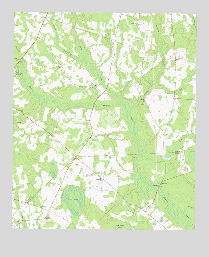
Bellevue, GA USGS Topographic Map
Click on map above to begin viewing in our Map Viewer.

This topographic map contains these locations and features:
Feature Name Type Latitude Longitude GNIS ID View Map
Beaverdam CreekStreamN32.9590°W82.0282°311001View Map
BellevuePopulated PlaceN32.9304°W82.0210°331125View Map
Big Buckhead Baptist ChurchChurchN32.9010°W82.0246°354709View Map
Big Buckhead Baptist Church CemeteryCemeteryN32.9004°W82.0237°342973View Map
Bynes ChapelChurchN32.9477°W82.1185°312126View Map
Carswell Grove ChurchChurchN32.9024°W82.0237°312361View Map
Carswell LakeReservoirN32.9163°W82.0185°341005View Map
Carswell Lake DamDamN32.9168°W82.0232°341004View Map
Days School (historical)SchoolN32.9938°W82.0401°347968View Map
Dooley BranchStreamN32.8843°W82.0076°313541View Map
Eightmile CreekStreamN32.9696°W82.1190°355650View Map
Fair-Haven ChurchChurchN32.8813°W82.1010°355751View Map
Fairhaven CemeteryCemeteryN32.8818°W82.1009°342978View Map
Fairhaven School (historical)SchoolN32.8815°W82.1012°342979View Map
Jones PondLakeN32.8918°W82.0832°316252View Map
Knight Irrigation Dam UpperDamN32.9302°W82.0665°342321View Map
Knight LakeReservoirN32.9295°W82.0645°340235View Map
Knight Lake DamDamN32.9302°W82.0615°340234View Map
Lower Miller LakeReservoirN32.8830°W82.1184°340301View Map
Lower Miller Lake DamDamN32.8802°W82.1165°340300View Map
McClough Grove ChurchChurchN32.9938°W82.0396°317866View Map
McCullough Millpond DamDamN32.9640°W82.1232°337235View Map
Mill CreekStreamN32.9182°W82.0373°318228View Map
Miller LakeReservoirN32.8875°W82.1205°341007View Map
Miller Lake DamDamN32.8868°W82.1198°341006View Map
Pet CemeteryCemeteryN32.9571°W82.0687°320402View Map
Pine Hill ChurchChurchN32.9685°W82.0932°320601View Map
Porter School (historical)SchoolN32.9499°W82.0351°348038View Map
Porterville ChurchChurchN32.9499°W82.0348°321074View Map
Rocky CreekStreamN32.9471°W82.0485°321817View Map
Rosemary CreekStreamN32.9435°W82.0465°310358View Map
Salters Grove ChurchChurchN32.9040°W82.0635°322384View Map
Souders Grove School (historical)SchoolN32.9038°W82.0635°343008View Map
Steiner BranchStreamN32.9718°W82.0754°323559View Map
Taylor Grove ChurchChurchN32.8877°W82.1048°323952View Map

Note: Coordinates in the location and feature list above are referenced to NAD83 datum.


Copyright (C) 2008-2024 Ryan Niemi / Sunset Dynamics ... All Rights Reserved