TopoQuest Logo
Do you find TopoQuest useful?
Help keep TopoQuest running and adding new maps/features by donating!
Bitcoin:  19c7KJd3qBynnjoSw5npx9KScwjBe4ifkT
Litecoin:  LXs6TkuXGGXo1vDsWCkWVdjQX94eUKd6ui
Home View Maps Find Maps Find Places Resources & Links


Bellevue, Iowa Topographic Map

USGS Map Title: Bellevue, IA
USGS Map MRC: 42090C4
DRG (GeoTIFF) Download: o42090c4.tif


Neighboring USGS Topographic Map Quads:


  Menominee, IL  
42090D5
 

  Galena, IL  
42090D4
 

  Scales Mound West, IL  
42090D3
 

  La Motte, IA  
42090C5
 

  Bellevue, IA  
42090C4
 

  Hanover, IL  
42090C3
 

  Andrew, IA  
42090B5
 

  Springbrook, IA  
42090B4
 

  Green Island, IA  
42090B3


Map MRC Location:

N43°
W91°
N43°
W90°
H8 H7 H6 H5 H4 H3 H2 H1
G8 G7 G6 G5 G4 G3 G2 G1
F8 F7 F6 F5 F4 F3 F2 F1
E8 E7 E6 E5 E4 E3 E2 E1
D8 D7 D6 D5 D4 D3 D2 D1
C8 C7 C6 C5 C4 C3 C2 C1
B8 B7 B6 B5 B4 B3 B2 B1
A8 A7 A6 A5 A4 A3 A2 A1
N42°
W91°
N42°
W90°

Bellevue, IA USGS 1:24K Topographic Map Preview:
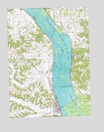
Bellevue, IA USGS Topographic Map
Click on map above to begin viewing in our Map Viewer.

This topographic map contains these locations and features:
Feature Name Type Latitude Longitude GNIS ID View Map
AikenPopulated PlaceN42.3525°W90.4154°422391View Map
Beaty HollowValleyN42.2752°W90.3839°404042View Map
BellevueLocaleN42.2583°W90.4224°2000959View Map
BellevuePopulated PlaceN42.2586°W90.4229°454496View Map
Bellevue Ambulance ServiceBuildingN42.2564°W90.4377°2599650View Map
Bellevue Ambulance ServiceBuildingN42.2565°W90.4377°2599950View Map
Bellevue Elementary SchoolSchoolN42.2577°W90.4259°2000967View Map
Bellevue Ferry (historical)LocaleN42.2606°W90.4201°1695194View Map
Bellevue Fire DepartmentBuildingN42.2583°W90.4259°2000956View Map
Bellevue Golf ClubLocaleN42.3145°W90.4409°2000952View Map
Bellevue Middle School / High SchoolSchoolN42.2545°W90.4437°2000966View Map
Bellevue Police DepartmentBuildingN42.2588°W90.4260°2000958View Map
Bellevue Post OfficePost OfficeN42.2614°W90.4249°2000953View Map
Bellevue Public LibraryBuildingN42.2583°W90.4257°2000957View Map
Bellevue SloughStreamN42.2997°W90.4312°454498View Map
Blackjack MineMineN42.3667°W90.4051°1695196View Map
BlandingPopulated PlaceN42.2747°W90.3860°422473View Map
Blanding Landing Recreation AreaLocaleN42.2858°W90.4035°424536View Map
California DigginsMineN42.3133°W90.4004°1815767View Map
City of BellevueCivilN42.2626°W90.4318°2394119View Map
Cole ParkParkN42.2597°W90.4312°2000991View Map
Daugherty Farm CemeteryCemeteryN42.2583°W90.4585°2001066View Map
Efferding CemeteryCemeteryN42.3431°W90.4710°2001071View Map
Federman Farms CemeteryCemeteryN42.3425°W90.4704°1958045View Map
First Presbyterian ChurchChurchN42.2589°W90.4265°2000963View Map
Galena JunctionPopulated PlaceN42.3739°W90.4432°422724View Map
Galena RiverStreamN42.3742°W90.4462°426934View Map
Hale IslandIslandN42.3456°W90.4335°409624View Map
Harris SloughStreamN42.3542°W90.4287°409849View Map
Jackson County Courthouse 1848-1861 Historical MarkerParkN42.2575°W90.4260°2000990View Map
Little Mill CreekStreamN42.2520°W90.4440°458484View Map
Lock and Dam 12DamN42.2614°W90.4204°425121View Map
Marquette Catholic Schools - Marquette High SchoolSchoolN42.2596°W90.4291°2000969View Map
Marquette Catholic Schools - Saint Joseph's Elementary SchoolSchoolN42.2597°W90.4282°2000968View Map
Marsden DigginsMineN42.3692°W90.4085°1815789View Map
Medical Associates ClinicHospitalN42.2556°W90.4376°2000961View Map
Mercy Health CenterHospitalN42.2595°W90.4246°2000960View Map
Mill CreekStreamN42.2508°W90.4179°459086View Map
Mill Valley Care CenterHospitalN42.2556°W90.4376°2000962View Map
Mud SloughStreamN42.3314°W90.4149°414203View Map
North BellevuePopulated PlaceN42.2783°W90.4346°464194View Map
North Spruce Creek Church CemeteryCemeteryN42.2917°W90.4873°1958176View Map
Oak Ridge School (historical)SchoolN42.3064°W90.3768°1695216View Map
Old City CemeteryCemeteryN42.2808°W90.4350°459825View Map
Palmer CemeteryCemeteryN42.2583°W90.4418°2001065View Map
Pool 12ReservoirN42.2652°W90.4215°2746776View Map
Potter CemeteryCemeteryN42.2931°W90.4876°2001068View Map
Potter's Mill (historical)LocaleN42.2508°W90.4212°2000954View Map
Prospect Hill Methodist Episcopalian CemeteryCemeteryN42.3531°W90.3765°416241View Map
RicePopulated PlaceN42.3392°W90.3946°423111View Map
Riverfront ParkParkN42.2603°W90.4229°2000992View Map
Royal Princess MineMineN42.3083°W90.3957°417019View Map
Saint Johns Lutheran ChurchChurchN42.2561°W90.4249°2000965View Map
Saint Joseph CemeteryCemeteryN42.2547°W90.4293°461091View Map
Saint Josephs Catholic ChurchChurchN42.2606°W90.4285°2000964View Map
Saint Nicholas Catholic CemeteryCemeteryN42.2917°W90.4835°2001067View Map
Scott IslandIslandN42.3192°W90.4265°461489View Map
Seawards IslandIslandN42.2586°W90.4146°1695220View Map
Smallpox CreekStreamN42.3490°W90.4277°418612View Map
Smith's Ferry Post Office (historical)Post OfficeN42.3236°W90.4335°2000901View Map
SmithsPopulated PlaceN42.3225°W90.4310°461709View Map
Spratts LakeLakeN42.3600°W90.4357°418917View Map
Spring Creek School (historical)SchoolN42.3533°W90.3999°1695222View Map
Spruce CreekStreamN42.3025°W90.4335°461927View Map
Spruce Creek Catholic CemeteryCemeteryN42.2997°W90.4424°2001069View Map
Spruce Creek ParkParkN42.3039°W90.4346°461928View Map
Spruce Mills Post Office (historical)Post OfficeN42.3014°W90.4412°2000902View Map
Stone SloughStreamN42.3455°W90.4273°419173View Map
Township of RiceCivilN42.3310°W90.3863°429627View Map
Township of Tete Des MortsCivilN42.3345°W90.4913°468787View Map
Weinert CemeteryCemeteryN42.3028°W90.4418°2001070View Map
Wise LakeLakeN42.3208°W90.4051°421353View Map
Yeager CreekStreamN42.3311°W90.4307°463239View Map
Yonkers LakeLakeN42.3022°W90.4074°421579View Map
Young Historical MuseumBuildingN42.2622°W90.4243°2000955View Map

Note: Coordinates in the location and feature list above are referenced to NAD83 datum.


Copyright (C) 2008-2024 Ryan Niemi / Sunset Dynamics ... All Rights Reserved