TopoQuest Logo
Do you find TopoQuest useful?
Help keep TopoQuest running and adding new maps/features by donating!
Bitcoin:  19c7KJd3qBynnjoSw5npx9KScwjBe4ifkT
Litecoin:  LXs6TkuXGGXo1vDsWCkWVdjQX94eUKd6ui
Home View Maps Find Maps Find Places Resources & Links


Newbern, Alabama Topographic Map

USGS Map Title: Newbern, AL
USGS Map MRC: 32087E5
DRG (GeoTIFF) Download: o32087e5.tif


Neighboring USGS Topographic Map Quads:


  Melton, AL  
32087F6
 

  Greensboro, AL  
32087F5
 

  Morgan Springs, AL  
32087F4
 

  Casemore, AL  
32087E6
 

  Newbern, AL  
32087E5
 

  Scott Station, AL  
32087E4
 

  Gallion, AL  
32087D6
 

  Uniontown West, AL  
32087D5
 

  Uniontown East, AL  
32087D4


Map MRC Location:

N33°
W88°
N33°
W87°
H8 H7 H6 H5 H4 H3 H2 H1
G8 G7 G6 G5 G4 G3 G2 G1
F8 F7 F6 F5 F4 F3 F2 F1
E8 E7 E6 E5 E4 E3 E2 E1
D8 D7 D6 D5 D4 D3 D2 D1
C8 C7 C6 C5 C4 C3 C2 C1
B8 B7 B6 B5 B4 B3 B2 B1
A8 A7 A6 A5 A4 A3 A2 A1
N32°
W88°
N32°
W87°

Newbern, AL USGS 1:24K Topographic Map Preview:
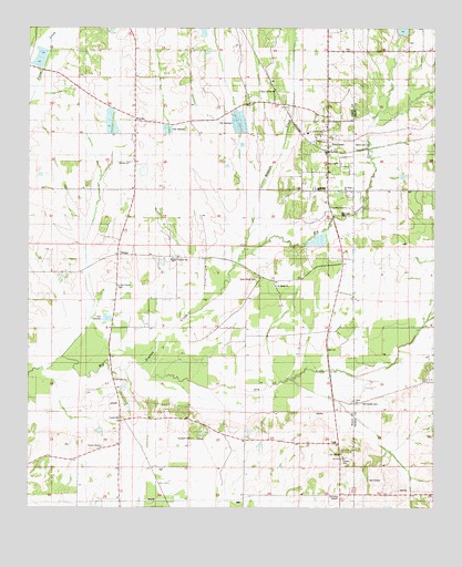
Newbern, AL USGS Topographic Map
Click on map above to begin viewing in our Map Viewer.

This topographic map contains these locations and features:
Feature Name Type Latitude Longitude GNIS ID View Map
Alex ChapelChurchN32.5579°W87.5972°112979View Map
Alexander CemeteryCemeteryN32.5410°W87.5975°158556View Map
B W Coleman Farm Dam Number 1DamN32.6001°W87.5983°130760View Map
B W Coleman Farm Dam Number 2DamN32.5985°W87.5983°130754View Map
Bester (historical)LocaleN32.6232°W87.5917°138950View Map
Blacksand (historical)LocaleN32.5612°W87.6153°138953View Map
Coleman Farm PondsReservoirN32.5987°W87.5982°130755View Map
Cottrell CemeteryCemeteryN32.5132°W87.5278°116697View Map
Cottrell Lake DamDamN32.5001°W87.5133°130630View Map
Curry Grove CemeteryCemeteryN32.5596°W87.5547°116978View Map
Dry CreekStreamN32.5371°W87.5908°117566View Map
Fowler CemeteryCemeteryN32.5171°W87.5297°158564View Map
Frank Watford StadiumParkN32.5636°W87.5803°2358911View Map
Hardenbergh LakeReservoirN32.6035°W87.5283°130772View Map
Hatch CemeteryCemeteryN32.5948°W87.5208°119836View Map
Hunter ChapelChurchN32.5160°W87.6025°151823View Map
Hunter Chapel CemeteryCemeteryN32.5157°W87.6031°158567View Map
Jack Hardenbergh DamDamN32.6035°W87.5283°130771View Map
Jollywell BranchStreamN32.5699°W87.5578°139004View Map
Jones School (historical)SchoolN32.5035°W87.5592°139005View Map
Kyser LakesReservoirN32.5696°W87.5365°130699View Map
Kyser Lakes Dam Number 4DamN32.5701°W87.5383°130701View Map
Kyser Lakes Dam Number 5DamN32.5701°W87.5367°130700View Map
Kyser Lakes Dam Number 6DamN32.5718°W87.5350°130707View Map
LanevillePopulated PlaceN32.5226°W87.5964°156578View Map
Lily Hill ChurchChurchN32.5143°W87.5286°121627View Map
Mars Hill ChurchChurchN32.6087°W87.5497°122295View Map
McCreary CemeteryCemeteryN32.5768°W87.5297°122505View Map
Morrissette CemeteryCemeteryN32.5276°W87.5222°123093View Map
Mount Horeb ChurchChurchN32.5582°W87.5489°152432View Map
Mount Sinai ChurchChurchN32.5332°W87.5983°123393View Map
Mount Valley ChurchChurchN32.5824°W87.5278°123408View Map
NewbernPopulated PlaceN32.5932°W87.5328°152687View Map
Newbern Baptist ChurchChurchN32.5957°W87.5336°149872View Map
Newbern CemeteryCemeteryN32.5935°W87.5306°149869View Map
Newbern Junior High SchoolSchoolN32.5976°W87.5392°149278View Map
Newbern Methodist ChurchChurchN32.5946°W87.5333°149871View Map
Newbern Post OfficePost OfficeN32.5993°W87.5332°168590View Map
Newbern Presbyterian ChurchChurchN32.5935°W87.5319°149870View Map
Newburn Volunteer Fire DepartmentBuildingN32.5994°W87.5327°2691381View Map
Pickens Mill (historical)LocaleN32.5382°W87.5931°139038View Map
Posey BranchStreamN32.5396°W87.6142°139045View Map
Sanctified ChurchChurchN32.5832°W87.5364°126292View Map
SledgeLocaleN32.5660°W87.5975°126965View Map
SunshinePopulated PlaceN32.5599°W87.5486°139067View Map
Sunshine Church (historical)ChurchN32.5649°W87.5806°139068View Map
Sunshine High SchoolSchoolN32.5649°W87.5808°165553View Map
Town of NewbernCivilN32.5920°W87.5332°2406982View Map
Tunstall CemeteryCemeteryN32.5182°W87.5744°128127View Map
Walthall LakeReservoirN32.5690°W87.5381°130704View Map
Walthall Lake DamDamN32.5701°W87.5383°130703View Map
Watershed Structure Number ElevenReservoirN32.6218°W87.5083°130801View Map
WhitsittPopulated PlaceN32.6010°W87.5922°157255View Map
Whitsitt ChurchChurchN32.5901°W87.5942°128929View Map
Whitsitt CreekStreamN32.5640°W87.5600°128930View Map
William Dale DamDamN32.5885°W87.5900°130742View Map
William Dale LakeReservoirN32.5878°W87.5896°130741View Map
Willie Woods Dam Number 1DamN32.6218°W87.6200°130802View Map
Willie Woods Dam Number 2DamN32.6151°W87.6200°130790View Map
Willie Woods Dam Number 3DamN32.6185°W87.6200°130796View Map
Willie Woods LakeReservoirN32.6160°W87.6220°130791View Map
Willie Woods LakeReservoirN32.6185°W87.6209°130795View Map

Note: Coordinates in the location and feature list above are referenced to NAD83 datum.


Copyright (C) 2008-2024 Ryan Niemi / Sunset Dynamics ... All Rights Reserved