TopoQuest Logo
Do you find TopoQuest useful?
Help keep TopoQuest running and adding new maps/features by donating!
Bitcoin:  19c7KJd3qBynnjoSw5npx9KScwjBe4ifkT
Litecoin:  LXs6TkuXGGXo1vDsWCkWVdjQX94eUKd6ui
Home View Maps Find Maps Find Places Resources & Links


Bellefontaine, Alabama Topographic Map

USGS Map Title: Bellefontaine, AL
USGS Map MRC: 30088D1
DRG (GeoTIFF) Download: o30088d1.tif


Neighboring USGS Topographic Map Quads:


  Theodore, AL  
30088E2
 

  Hollingers Island, AL  
30088E1
 

  Daphne, AL  
30087E8
 

  Coden, AL  
30088D2
 

  Bellefontaine, AL  
30088D1
 

  Point Clear, AL  
30087D8
 

  Heron Bay, AL  
30088C2
 

  Little Dauphin Island, AL  
30088C1
 

  Little Point Clear, AL  
30087C8


Map MRC Location:

N31°
W89°
N31°
W88°
H8 H7 H6 H5 H4 H3 H2 H1
G8 G7 G6 G5 G4 G3 G2 G1
F8 F7 F6 F5 F4 F3 F2 F1
E8 E7 E6 E5 E4 E3 E2 E1
D8 D7 D6 D5 D4 D3 D2 D1
C8 C7 C6 C5 C4 C3 C2 C1
B8 B7 B6 B5 B4 B3 B2 B1
A8 A7 A6 A5 A4 A3 A2 A1
N30°
W89°
N30°
W88°

Bellefontaine, AL USGS 1:24K Topographic Map Preview:
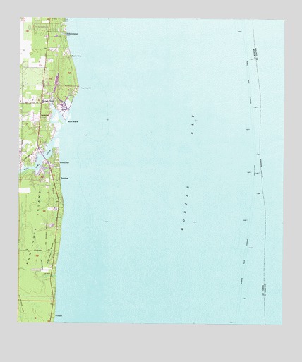
Bellefontaine, AL USGS Topographic Map
Click on map above to begin viewing in our Map Viewer.

This topographic map contains these locations and features:
Feature Name Type Latitude Longitude GNIS ID View Map
Austin BayouStreamN30.4180°W88.1039°113285View Map
Baumhauer Road Baptist ChurchChurchN30.4463°W88.1172°2579340View Map
Bayleys CornerPopulated PlaceN30.4649°W88.1144°113596View Map
Belle Fontaine Census Designated PlaceCensusN30.4919°W88.1106°2632282View Map
BellefontainePopulated PlaceN30.4935°W88.1036°113875View Map
Bellefontaine ChurchChurchN30.4466°W88.1161°1729952View Map
Boudans CemeteryCemeteryN30.4999°W88.1072°114761View Map
Delchamps BayouStreamN30.3946°W88.1067°117215View Map
East Fowl RiverStreamN30.4519°W88.1061°117768View Map
FaustinasPopulated PlaceN30.4338°W88.1056°118222View Map
Fowl River MarinaLocaleN30.4449°W88.1135°2579748View Map
Fowl River PointCapeN30.4719°W88.0967°118563View Map
Goat IslandIslandN30.4569°W88.1036°119067View Map
Mathis CemeteryCemeteryN30.4995°W88.1076°2579350View Map
Mobile BayBayN30.4427°W88.0092°158872View Map
Mobile Bay LightLocaleN30.4374°W88.0117°143539View Map
Mobile Ship ChannelChannelN30.4538°W88.0142°152355View Map
Mon LouisPopulated PlaceN30.4405°W88.1058°152356View Map
Pecan Grove Trailer ParkPopulated PlaceN30.4741°W88.1144°2579853View Map
Point JudithCapeN30.3783°W88.1072°125080View Map
Point Judith Gas FieldOilfieldN30.3821°W88.1217°151202View Map
S A Barrett DamDamN30.4752°W88.1083°129522View Map
Saint Rose ChurchChurchN30.4391°W88.1075°1730025View Map
SmithportPopulated PlaceN30.4594°W88.1150°127044View Map
South Mobile First Baptist ChurchChurchN30.4711°W88.1132°2579339View Map
Sunny CovePopulated PlaceN30.4841°W88.1008°127557View Map
Whitehouse BayouStreamN30.3983°W88.1067°128901View Map
WMOZ-AM (Mobile)TowerN30.3866°W88.0378°160878View Map

Note: Coordinates in the location and feature list above are referenced to NAD83 datum.


Copyright (C) 2008-2024 Ryan Niemi / Sunset Dynamics ... All Rights Reserved