TopoQuest Logo
Do you find TopoQuest useful?
Help keep TopoQuest running and adding new maps/features by donating!
Bitcoin:  19c7KJd3qBynnjoSw5npx9KScwjBe4ifkT
Litecoin:  LXs6TkuXGGXo1vDsWCkWVdjQX94eUKd6ui
Home View Maps Find Maps Find Places Resources & Links


New Hartford, Connecticut Topographic Map

USGS Map Title: New Hartford, CT
USGS Map MRC: 41072H8
DRG (GeoTIFF) Download: o41072h8.tif


Neighboring USGS Topographic Map Quads:


  Winsted, CT  
41073H1
 

  New Hartford, CT  
41072H8
 

  Tariffville, CT  
41072H7
 

  Torrington, CT  
41073G1
 

  Collinsville, CT  
41072G8
 

  Avon, CT  
41072G7


Map MRC Location:

N42°
W73°
N42°
W72°
H8 H7 H6 H5 H4 H3 H2 H1
G8 G7 G6 G5 G4 G3 G2 G1
F8 F7 F6 F5 F4 F3 F2 F1
E8 E7 E6 E5 E4 E3 E2 E1
D8 D7 D6 D5 D4 D3 D2 D1
C8 C7 C6 C5 C4 C3 C2 C1
B8 B7 B6 B5 B4 B3 B2 B1
A8 A7 A6 A5 A4 A3 A2 A1
N41°
W73°
N41°
W72°

New Hartford, CT USGS 1:24K Topographic Map Preview:
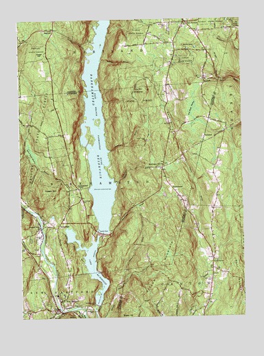
New Hartford, CT USGS Topographic Map
Click on map above to begin viewing in our Map Viewer.

This topographic map contains these locations and features:
Feature Name Type Latitude Longitude GNIS ID View Map
Barkhampsted CenterPopulated PlaceN41.9290°W72.9665°212415View Map
BarkhamstedPopulated PlaceN41.9293°W72.9140°212416View Map
Barkhamsted CemeteryCemeteryN41.9236°W72.9652°205258View Map
Barkhamsted East Fire CompanyBuildingN41.9309°W72.9156°2420256View Map
Barkhamsted Elementary SchoolSchoolN41.9112°W72.9898°1931780View Map
Beaver BrookStreamN41.9132°W72.9732°205369View Map
Beaver Brook MeadowSwampN41.9440°W72.9929°205372View Map
Beech RockLocaleN41.9176°W72.9618°205411View Map
Bethany ChurchChurchN41.9984°W72.9162°205472View Map
Callahan ParkParkN41.8798°W72.9734°1931839View Map
Center HillSummitN41.9851°W72.9873°206133View Map
Compensating ReservoirReservoirN41.8801°W72.9579°1770910View Map
East HartlandPopulated PlaceN41.9990°W72.9054°206822View Map
East Hartland CemeteryCemeteryN41.9998°W72.9046°1944207View Map
East Hartland Post OfficePost OfficeN41.9976°W72.9078°1943542View Map
East Hartland Volunteer Fire DepartmentBuildingN41.9967°W72.9077°2420040View Map
East Mountain BrookStreamN41.8765°W72.9790°206838View Map
Gilbert BridgeBridgeN41.9129°W72.9876°1931995View Map
Goose GreenLocaleN41.9137°W72.9782°207364View Map
Greenwood Industrial ParkLocaleN41.8840°W72.9679°1932016View Map
Hallock BrookStreamN41.8776°W72.9768°207620View Map
HampstedPopulated PlaceN41.9504°W72.8954°212470View Map
HartlandPopulated PlaceN41.9962°W72.9795°212474View Map
Hartland Elementary SchoolSchoolN41.9073°W72.8965°1944210View Map
Hartland Fire Marshal's OfficeBuildingN41.9975°W72.9070°2420083View Map
Hartland Second Congregational ChurchChurchN41.9993°W72.9057°1943704View Map
Hartland Town HallBuildingN41.9993°W72.9065°1943705View Map
Holcomb HillSummitN41.8918°W72.9726°207885View Map
Hoyt Hayes SwampSwampN41.9622°W72.9024°207993View Map
Immaculate Conception CemeteryCemeteryN41.8781°W72.9822°1932069View Map
Immaculate Conception ChurchChurchN41.8779°W72.9834°1932070View Map
J O Enders State ForestForestN41.9620°W72.9051°1932084View Map
Kettle BrookStreamN41.9320°W72.9445°208278View Map
Lake Mc DonoughReservoirN41.8980°W72.9611°206405View Map
Merrit CampLocaleN41.9890°W72.9007°208839View Map
Morgan BrookStreamN41.9020°W72.9876°209037View Map
New HartfordPopulated PlaceN41.8823°W72.9770°209229View Map
New Hartford Center Census Designated PlaceCensusN41.8802°W72.9753°2377835View Map
New Hartford Elementary SchoolSchoolN41.8773°W72.9673°1932217View Map
New Hartford Fire Department Station 1BuildingN41.8794°W72.9767°2420331View Map
New Hartford Fire Marshal's OfficeBuildingN41.8792°W72.9797°2420370View Map
New Hartford Free Public LibraryBuildingN41.8787°W72.9798°1932218View Map
New Hartford Historical Society MuseumBuildingN41.8787°W72.9798°1932219View Map
New Hartford Industrial ParkLocaleN41.8820°W72.9793°1932220View Map
New Hartford Post OfficePost OfficeN41.8797°W72.9808°1932221View Map
New Hartford Town HallBuildingN41.8795°W72.9798°1932222View Map
New Hartford Volunteer Ambulance ServiceBuildingN41.8799°W72.9775°2660898View Map
North CantonPopulated PlaceN41.8979°W72.8926°212524View Map
North Canton CemeteryCemeteryN41.8899°W72.8937°209333View Map
North Canton Community United Methodist ChurchChurchN41.8926°W72.8918°1944211View Map
North Canton Post OfficePost OfficeN41.8930°W72.8925°1943868View Map
North Canton Volunteer Fire DepartmentBuildingN41.8945°W72.8930°2420037View Map
Old School House MuseumBuildingN41.9282°W72.9662°1932272View Map
Peoples State ForestForestN41.9462°W72.9909°209704View Map
Pine Grove CemeteryCemeteryN41.8785°W72.9611°209774View Map
Pine MeadowPopulated PlaceN41.8765°W72.9670°209789View Map
Pine MountainSummitN41.9712°W72.9287°209793View Map
Pleasant ValleyPopulated PlaceN41.9123°W72.9879°209846View Map
Pleasant Valley Post OfficePost OfficeN41.9115°W72.9883°1932293View Map
Pleasant Valley United Methodist ChurchChurchN41.9098°W72.9873°1932294View Map
Pleasant Valley Volunteer Fire DepartmentBuildingN41.9134°W72.9808°2420393View Map
Ragged MountainSummitN41.9293°W72.9859°210088View Map
Ratlum MountainSummitN41.8887°W72.9282°210103View Map
Richards Corner DamDamN41.8801°W72.9568°210177View Map
Riverside CemeteryCemeteryN41.9093°W72.9882°210215View Map
Roaring BrookStreamN41.9454°W72.9476°210227View Map
Roberts BrookStreamN41.9829°W72.9523°210239View Map
Saville DamDamN41.9095°W72.9534°210659View Map
Sawmill BrookStreamN41.9879°W72.9601°210666View Map
Spruce BrookStreamN41.8920°W72.9404°211099View Map
Storehouse BrookStreamN41.9093°W72.9534°211230View Map
Town of BarkhamstedCivilN41.9316°W72.9728°213386View Map
Washington HillSummitN41.9540°W72.9143°211830View Map
Washington Hill ChurchChurchN41.9390°W72.9182°211831View Map
Wright BrookStreamN41.9748°W72.8870°212285View Map

Note: Coordinates in the location and feature list above are referenced to NAD83 datum.


Copyright (C) 2008-2024 Ryan Niemi / Sunset Dynamics ... All Rights Reserved