TopoQuest Logo
Do you find TopoQuest useful?
Help keep TopoQuest running and adding new maps/features by donating!
Bitcoin:  19c7KJd3qBynnjoSw5npx9KScwjBe4ifkT
Litecoin:  LXs6TkuXGGXo1vDsWCkWVdjQX94eUKd6ui
Home View Maps Find Maps Find Places Resources & Links


New Ellenton, South Carolina Topographic Map

USGS Map Title: New Ellenton, SC
USGS Map MRC: 33081D6
DRG (GeoTIFF) Download: o33081d6.tif


Neighboring USGS Topographic Map Quads:


  Graniteville, SC  
33081E7
 

  Aiken, SC  
33081E6
 

  Oakwood, SC  
33081E5
 

  Hollow Creek, SC  
33081D7
 

  New Ellenton, SC  
33081D6
 

  Windsor, SC  
33081D5
 

  Jackson, SC  
33081C7
 

  New Ellenton SW, SC  
33081C6
 

  New Ellenton SE, SC  
33081C5


Map MRC Location:

N34°
W82°
N34°
W81°
H8 H7 H6 H5 H4 H3 H2 H1
G8 G7 G6 G5 G4 G3 G2 G1
F8 F7 F6 F5 F4 F3 F2 F1
E8 E7 E6 E5 E4 E3 E2 E1
D8 D7 D6 D5 D4 D3 D2 D1
C8 C7 C6 C5 C4 C3 C2 C1
B8 B7 B6 B5 B4 B3 B2 B1
A8 A7 A6 A5 A4 A3 A2 A1
N33°
W82°
N33°
W81°

New Ellenton, SC USGS 1:24K Topographic Map Preview:
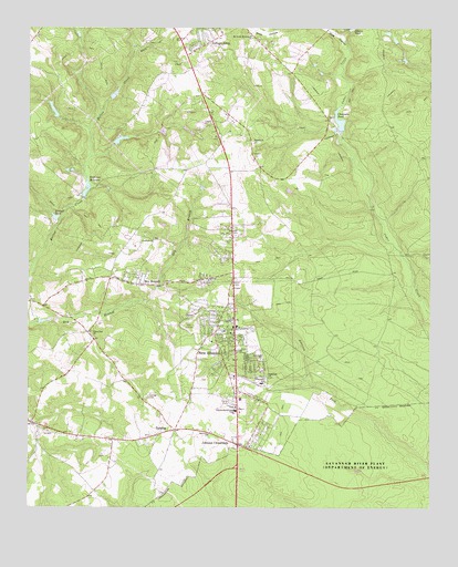
New Ellenton, SC USGS Topographic Map
Click on map above to begin viewing in our Map Viewer.

This topographic map contains these locations and features:
Feature Name Type Latitude Longitude GNIS ID View Map
Aiken Public Safety Department Station 5BuildingN33.4936°W81.6977°2578688View Map
Aiken Public Safety Station 4BuildingN33.4974°W81.7478°2578170View Map
Anderson MillpondReservoirN33.4581°W81.7320°1237970View Map
Berry CemeteryCemeteryN33.3851°W81.6840°1236238View Map
Brookhaven EstatesPopulated PlaceN33.4988°W81.7132°1236259View Map
Burdens Deep PondReservoirN33.4787°W81.7423°1238078View Map
Cedar Creek Church (historical)ChurchN33.4357°W81.6348°1236273View Map
Cedar Creek School (historical)SchoolN33.4713°W81.6415°1236274View Map
Cedar Grove Church (historical)ChurchN33.4543°W81.6415°1236275View Map
Chapman PondReservoirN33.4759°W81.6532°1221512View Map
Chime Bell Baptist ChurchChurchN33.4204°W81.7307°1247285View Map
Chukker CreekPopulated PlaceN33.4835°W81.7068°1236283View Map
College AcresPopulated PlaceN33.4960°W81.6951°1231183View Map
Corinth Baptist ChurchChurchN33.4013°W81.6854°1236288View Map
Dry BranchPopulated PlaceN33.4335°W81.7182°1231242View Map
Fair Hill Church (historical)ChurchN33.4763°W81.6934°1236313View Map
Fairfield CemeteryCemeteryN33.3846°W81.6484°1236314View Map
Fairfield ChurchChurchN33.4090°W81.6757°1222336View Map
Fairfield Church (historical)ChurchN33.3840°W81.6482°1236315View Map
Fairview School (historical)SchoolN33.4793°W81.6948°1236318View Map
Foreman Memorial Baptist ChurchChurchN33.4213°W81.6890°1236329View Map
Four Mile Baptist ChurchChurchN33.4135°W81.6773°1247817View Map
Greendale SchoolSchoolN33.4074°W81.6771°1245836View Map
Gum Ford School (historical)SchoolN33.4518°W81.6746°1236353View Map
Hitchcock Mill Pond (historical)ReservoirN33.4415°W81.6334°1236373View Map
Holley LakeReservoirN33.4981°W81.7346°1236375View Map
Hunters GlenPopulated PlaceN33.4921°W81.6943°1236382View Map
Johnson CrossroadsPopulated PlaceN33.3913°W81.6846°1246186View Map
Kimball PondLakeN33.4508°W81.7417°1223732View Map
Mission Church (historical)ChurchN33.3779°W81.6526°1236436View Map
Mount Anna Baptist ChurchChurchN33.4976°W81.6804°1249538View Map
Mount Enon Church (historical)ChurchN33.4899°W81.6823°1236446View Map
New EllentonPopulated PlaceN33.4215°W81.6857°1231587View Map
New Ellenton Country ClubLocaleN33.4224°W81.6990°1236450View Map
New Ellenton DivisionCivilN33.4331°W81.7072°1938364View Map
New Ellenton Fire DepartmentBuildingN33.4191°W81.6834°2578301View Map
New Ellenton Police DepartmentBuildingN33.4211°W81.6851°2734274View Map
New Ellenton Post OfficePost OfficeN33.4254°W81.6851°1252215View Map
Oak HillPopulated PlaceN33.4440°W81.6946°1236463View Map
Pineview ChurchChurchN33.3940°W81.6934°1225479View Map
Saint Paul United Methodist ChurchChurchN33.4093°W81.6857°1236517View Map
South Carolina Noname 02018 D-2000 DamDamN33.4579°W81.7321°1237969View Map
South Carolina Noname 02026 D-2004 DamDamN33.4735°W81.6521°1237980View Map
South Carolina Noname 02111 D-2049 DamDamN33.4768°W81.7415°1238077View Map
Spring CemeteryCemeteryN33.4037°W81.7123°1226814View Map
Spring Church (historical)ChurchN33.4038°W81.7129°1236551View Map
TalathaPopulated PlaceN33.3951°W81.7046°1227022View Map
Talatha Baptist ChurchChurchN33.4704°W81.6796°1251112View Map
Talatha Church (historical)ChurchN33.4785°W81.6879°1236559View Map
Talatha FarmsPopulated PlaceN33.4821°W81.6834°1236560View Map
Talatha School (historical)SchoolN33.4065°W81.7168°1236561View Map
Talatha-Hawthorne SchoolSchoolN33.4004°W81.6854°1251113View Map
Town of New EllentonCivilN33.4192°W81.6814°2406974View Map
Williamson LakeReservoirN33.4709°W81.7216°1239182View Map
Williamson Lake Dam D-2050DamN33.4701°W81.7232°1239181View Map
Wise HollowValleyN33.4929°W81.6509°1227663View Map
Zion Fair Baptist ChurchChurchN33.4343°W81.6937°1251563View Map
Zion Field Baptist ChurchChurchN33.4449°W81.7112°1251564View Map

Note: Coordinates in the location and feature list above are referenced to NAD83 datum.


Copyright (C) 2008-2024 Ryan Niemi / Sunset Dynamics ... All Rights Reserved