TopoQuest Logo
Do you find TopoQuest useful?
Help keep TopoQuest running and adding new maps/features by donating!
Bitcoin:  19c7KJd3qBynnjoSw5npx9KScwjBe4ifkT
Litecoin:  LXs6TkuXGGXo1vDsWCkWVdjQX94eUKd6ui
Home View Maps Find Maps Find Places Resources & Links


New Amsterdam, Indiana Topographic Map

USGS Map Title: New Amsterdam, IN
USGS Map MRC: 38086A3
DRG (GeoTIFF) Download: o38086a3.tif


Neighboring USGS Topographic Map Quads:


  Beechwood, IN  
38086B4
 

  Leavenworth, IN  
38086B3
 

  Corydon West, IN  
38086B2
 

  Alton, IN  
38086A4
 

  New Amsterdam, IN  
38086A3
 

  Mauckport, IN  
38086A2
 

  Lodiburg, KY  
37086H4
 

  Irvington, KY  
37086H3
 

  Guston, KY  
37086H2


Map MRC Location:

N39°
W87°
N39°
W86°
H8 H7 H6 H5 H4 H3 H2 H1
G8 G7 G6 G5 G4 G3 G2 G1
F8 F7 F6 F5 F4 F3 F2 F1
E8 E7 E6 E5 E4 E3 E2 E1
D8 D7 D6 D5 D4 D3 D2 D1
C8 C7 C6 C5 C4 C3 C2 C1
B8 B7 B6 B5 B4 B3 B2 B1
A8 A7 A6 A5 A4 A3 A2 A1
N38°
W87°
N38°
W86°

New Amsterdam, IN USGS 1:24K Topographic Map Preview:
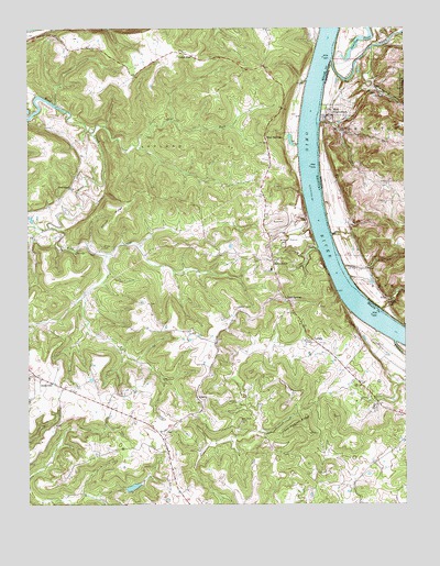
New Amsterdam, IN USGS Topographic Map
Click on map above to begin viewing in our Map Viewer.

This topographic map contains these locations and features:
Feature Name Type Latitude Longitude GNIS ID View Map
AndyvillePopulated PlaceN38.0340°W86.3725°507399View Map
Ball KnobSummitN38.0216°W86.3045°2742580View Map
BattletownPopulated PlaceN38.0640°W86.2939°486474View Map
Battletown Fire DepartmentBuildingN38.0634°W86.2934°2636885View Map
Battletown-Payneville DivisionCivilN38.0473°W86.3440°1936867View Map
BeechlandPopulated PlaceN38.0831°W86.3608°507479View Map
Bell Knob CemeteryCemeteryN38.0217°W86.3050°486796View Map
Bennett CemeteryCemeteryN38.0681°W86.2902°486857View Map
Big SpringSpringN38.1073°W86.2571°447913View Map
Blue Spring HollowValleyN38.1091°W86.2612°431253View Map
Brock CreekStreamN38.1120°W86.2903°431552View Map
Cedar FlatPopulated PlaceN38.1181°W86.3216°507671View Map
Cedar FlatsFlatN38.1196°W86.3307°2742584View Map
Chism CemeteryCemeteryN38.0678°W86.3505°489484View Map
Chism RidgeRidgeN38.0767°W86.3453°489486View Map
Cold SpringsPopulated PlaceN38.0540°W86.2894°507728View Map
Crown Hill CemeteryCemeteryN38.1201°W86.3000°433209View Map
Crozier BottomFlatN38.0377°W86.2535°2742585View Map
Dry ForkStreamN38.0987°W86.3528°491197View Map
French CreekStreamN38.0428°W86.2536°492521View Map
Gas Well HollowValleyN38.0320°W86.2512°2036648View Map
Greer CemeteryCemeteryN38.0742°W86.2941°493358View Map
Indian CreekStreamN38.1167°W86.2739°449807View Map
LaplandAreaN38.0934°W86.3297°495988View Map
Lawson ParkParkN38.0667°W86.2928°496093View Map
LibertyPopulated PlaceN38.0281°W86.3191°508454View Map
LodalePopulated PlaceN38.0431°W86.2808°517061View Map
Lopp HollowValleyN38.0532°W86.2557°438306View Map
Lopps Landing (historical)LocaleN38.0517°W86.2580°447912View Map
Mint SpringsLocaleN38.0970°W86.2964°498427View Map
New AmsterdamPopulated PlaceN38.1023°W86.2750°440016View Map
OolitePopulated PlaceN38.0678°W86.2800°508753View Map
Overflow PondLakeN38.1214°W86.2655°452475View Map
Prather HollowValleyN38.0010°W86.3711°501285View Map
The KnobSummitN38.0841°W86.3705°2742598View Map
TitusPopulated PlaceN38.0542°W86.2561°444787View Map
Town of New AmsterdamCivilN38.1020°W86.2757°2396798View Map
Turkey Heaven RidgeRidgeN38.0215°W86.2850°505609View Map

Note: Coordinates in the location and feature list above are referenced to NAD83 datum.


Copyright (C) 2008-2024 Ryan Niemi / Sunset Dynamics ... All Rights Reserved