TopoQuest Logo
Do you find TopoQuest useful?
Help keep TopoQuest running and adding new maps/features by donating!
Bitcoin:  19c7KJd3qBynnjoSw5npx9KScwjBe4ifkT
Litecoin:  LXs6TkuXGGXo1vDsWCkWVdjQX94eUKd6ui
Home View Maps Find Maps Find Places Resources & Links


Nevada, Missouri Topographic Map

USGS Map Title: Nevada, MO
USGS Map MRC: 37094G3
DRG (GeoTIFF) Download: o37094g3.tif


Neighboring USGS Topographic Map Quads:


  Metz, MO  
37094H4
 

  Horton, MO  
37094H3
 

  Harwood, MO  
37094H2
 

  Moundville, MO  
37094G4
 

  Nevada, MO  
37094G3
 

  Dederick, MO  
37094G2
 

  Bronaugh, MO  
37094F4
 

  Sheldon, MO  
37094F3
 

  Bellamy, MO  
37094F2


Map MRC Location:

N38°
W95°
N38°
W94°
H8 H7 H6 H5 H4 H3 H2 H1
G8 G7 G6 G5 G4 G3 G2 G1
F8 F7 F6 F5 F4 F3 F2 F1
E8 E7 E6 E5 E4 E3 E2 E1
D8 D7 D6 D5 D4 D3 D2 D1
C8 C7 C6 C5 C4 C3 C2 C1
B8 B7 B6 B5 B4 B3 B2 B1
A8 A7 A6 A5 A4 A3 A2 A1
N37°
W95°
N37°
W94°

Nevada, MO USGS 1:24K Topographic Map Preview:
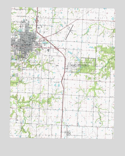
Nevada, MO USGS Topographic Map
Click on map above to begin viewing in our Map Viewer.

This topographic map contains these locations and features:
Feature Name Type Latitude Longitude GNIS ID View Map
Benton Elementary SchoolSchoolN37.8450°W94.3509°748221View Map
Bethel ChapelChurchN37.7670°W94.3672°714037View Map
Bethel School (historical)SchoolN37.7684°W94.3683°746147View Map
Board School (historical)SchoolN37.8720°W94.3244°748337View Map
BristowPopulated PlaceN37.8050°W94.2644°714723View Map
Bryan Elementary SchoolSchoolN37.8439°W94.3611°748222View Map
Callaway CemeteryCemeteryN37.8727°W94.3662°748228View Map
Camp ClarkMilitaryN37.8203°W94.2916°2512448View Map
Camp Clark Army HeliportAirportN37.8167°W94.3002°758828View Map
Centennial ParkParkN37.8423°W94.3358°748233View Map
Charles Vincent DamDamN37.8134°W94.3019°763196View Map
Charles Vincent ReservoirReservoirN37.8134°W94.3019°763197View Map
City of NevadaCivilN37.8446°W94.3493°2395179View Map
Click CemeteryCemeteryN37.8545°W94.3338°715976View Map
Cottey CollegeSchoolN37.8370°W94.3709°746148View Map
Countryside Assembly of God ChurchChurchN37.8359°W94.3358°748236View Map
Deepwood CemeteryCemeteryN37.8295°W94.3551°716792View Map
Fern School (historical)SchoolN37.7784°W94.3380°748361View Map
First Baptist ChurchChurchN37.8409°W94.3577°748226View Map
First Christian ChurchChurchN37.8367°W94.3563°748224View Map
Franklin School (historical)SchoolN37.8357°W94.3650°748216View Map
George Lyons ParkParkN37.8573°W94.3447°748231View Map
Heritage Baptist ChurchChurchN37.8481°W94.3716°748227View Map
Highway School (historical)SchoolN37.8045°W94.2616°748381View Map
Izaak Walton LakeReservoirN37.8534°W94.3652°758294View Map
Izaak Walton Lake DamDamN37.8534°W94.3652°762896View Map
John L Cunningham DamDamN37.7884°W94.3569°763198View Map
John L Cunningham ReservoirReservoirN37.7884°W94.3569°763199View Map
Katy Allen LakeReservoirN37.8414°W94.3351°758296View Map
Katy Allen Lake DamDamN37.8417°W94.3369°763106View Map
KNEM-AM (Nevada)TowerN37.8306°W94.3488°759216View Map
Landon BranchStreamN37.7814°W94.3644°720789View Map
Mapledale School (historical)SchoolN37.8070°W94.3111°748405View Map
Marmaduke ParkParkN37.8611°W94.3702°748230View Map
Marquardt DamDamN37.8284°W94.3002°763084View Map
Marquardt LakeReservoirN37.8284°W94.3002°763085View Map
Marvin Chapel (historical)ChurchN37.7903°W94.2566°748407View Map
Marvin Chapel CemeteryCemeteryN37.7909°W94.2569°748240View Map
MiloPopulated PlaceN37.7562°W94.3061°722412View Map
Milo CemeteryCemeteryN37.7534°W94.3058°748214View Map
Milo Post OfficePost OfficeN37.7557°W94.3056°2782577View Map
Milo Rural Fire DepartmentBuildingN37.7556°W94.3054°2621645View Map
Milo School (historical)SchoolN37.7623°W94.3065°748410View Map
Moore CemeteryCemeteryN37.8174°W94.3601°722574View Map
Mount Calvary CemeteryCemeteryN37.8478°W94.3738°748234View Map
Nassau JunctionPopulated PlaceN37.8203°W94.3219°741091View Map
NevadaPopulated PlaceN37.8392°W94.3547°729934View Map
Nevada Country ClubLocaleN37.8214°W94.3686°755337View Map
Nevada Fire DepartmentBuildingN37.8374°W94.3597°2621223View Map
Nevada High SchoolSchoolN37.8437°W94.3663°748218View Map
Nevada Middle SchoolSchoolN37.8477°W94.3705°748220View Map
Nevada Municipal AirportAirportN37.8552°W94.3054°758827View Map
Nevada Police DepartmentBuildingN37.8380°W94.3599°2752116View Map
Nevada Post OfficePost OfficeN37.8379°W94.3545°2779495View Map
Nevada Regional Medical CenterHospitalN37.8305°W94.3604°748215View Map
Nevada Regional Technical CenterSchoolN37.8455°W94.3684°748219View Map
Nevada State Hospital CemeteryCemeteryN37.8723°W94.3673°2572600View Map
Newton CemeteryCemeteryN37.8567°W94.3638°723342View Map
Oakdale School (historical)SchoolN37.7987°W94.3668°748424View Map
Postlethwaite ParkParkN37.8228°W94.3552°748238View Map
Prairie Valley School (historical)SchoolN37.8356°W94.3094°748442View Map
Radio Springs ParkParkN37.8270°W94.3716°748235View Map
Radio Springs Park DamDamN37.8250°W94.3731°762831View Map
Spring Street ParkParkN37.8298°W94.3619°748237View Map
Stanton School (historical)SchoolN37.8378°W94.2544°748459View Map
Township of CenterCivilN37.8071°W94.3473°767481View Map
Truman Elementary SchoolSchoolN37.8441°W94.3688°2743609View Map
Twin Lakes ParkParkN37.8048°W94.3211°748239View Map
Union School (historical)SchoolN37.8731°W94.3577°748468View Map
United Methodist ChurchChurchN37.8342°W94.3711°748225View Map
Vernon CountyCivilN37.8506°W94.3424°758561View Map
Vernon County Sheriff's OfficeBuildingN37.8395°W94.3319°2752111View Map
Village of MiloCivilN37.7554°W94.3051°2399365View Map
Walton ParkParkN37.8523°W94.3616°748232View Map
West Fairview Church (historical)ChurchN37.8664°W94.2702°748473View Map
Willow BranchStreamN37.8240°W94.3554°728919View Map
Wilson Lake DamDamN37.8634°W94.2536°763282View Map
Woods School (historical)SchoolN37.7753°W94.2652°748482View Map

Note: Coordinates in the location and feature list above are referenced to NAD83 datum.


Copyright (C) 2008-2024 Ryan Niemi / Sunset Dynamics ... All Rights Reserved