TopoQuest Logo
Do you find TopoQuest useful?
Help keep TopoQuest running and adding new maps/features by donating!
Bitcoin:  19c7KJd3qBynnjoSw5npx9KScwjBe4ifkT
Litecoin:  LXs6TkuXGGXo1vDsWCkWVdjQX94eUKd6ui
Home View Maps Find Maps Find Places Resources & Links


Needville, Texas Topographic Map

USGS Map Title: Needville, TX
USGS Map MRC: 29095D7
DRG (GeoTIFF) Download: o29095d7.tif


Neighboring USGS Topographic Map Quads:


  Orchard, TX  
29095E8
 

  Richmond, TX  
29095E7
 

  Sugar Land, TX  
29095E6
 

  Kendleton, TX  
29095D8
 

  Needville, TX  
29095D7
 

  Smithers Lake, TX  
29095D6
 

  Boling, TX  
29095C8
 

  Guy, TX  
29095C7
 

  Damon, TX  
29095C6


Map MRC Location:

N30°
W96°
N30°
W95°
H8 H7 H6 H5 H4 H3 H2 H1
G8 G7 G6 G5 G4 G3 G2 G1
F8 F7 F6 F5 F4 F3 F2 F1
E8 E7 E6 E5 E4 E3 E2 E1
D8 D7 D6 D5 D4 D3 D2 D1
C8 C7 C6 C5 C4 C3 C2 C1
B8 B7 B6 B5 B4 B3 B2 B1
A8 A7 A6 A5 A4 A3 A2 A1
N29°
W96°
N29°
W95°

Needville, TX USGS 1:24K Topographic Map Preview:
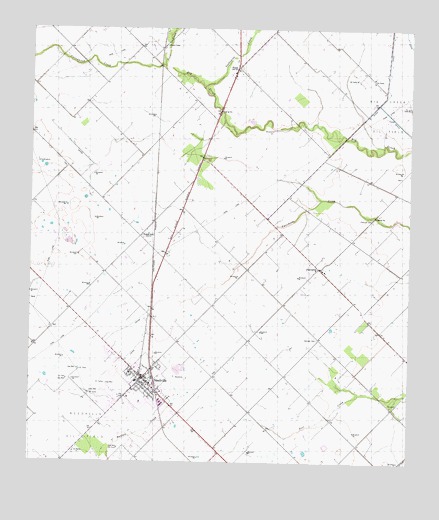
Needville, TX USGS Topographic Map
Click on map above to begin viewing in our Map Viewer.

This topographic map contains these locations and features:
Feature Name Type Latitude Longitude GNIS ID View Map
Cesinger CemeteryCemeteryN29.4108°W95.7805°1332605View Map
City of NeedvilleCivilN29.3957°W95.8387°2411221View Map
Concord CemeteryCemeteryN29.4452°W95.7625°1333208View Map
Coon CreekStreamN29.4897°W95.8319°1329125View Map
Cottonwood CreekStreamN29.4894°W95.8319°1333453View Map
Fairchild Volunteer Fire Department - First RespondersBuildingN29.4326°W95.7765°2334435View Map
FairchildsPopulated PlaceN29.4314°W95.7802°1378280View Map
Fort Bend County Constable's Office Precinct 1 Needville OfficeBuildingN29.4012°W95.8393°2751463View Map
Foster SchoolLocaleN29.4405°W95.8388°1336091View Map
NeedvillePopulated PlaceN29.3994°W95.8377°1342402View Map
Needville City HallBuildingN29.3986°W95.8375°2753579View Map
Needville Community Assembly of God ChurchChurchN29.4073°W95.8374°2471086View Map
Needville Elementary SchoolSchoolN29.3925°W95.8381°2005782View Map
Needville Police DepartmentBuildingN29.3983°W95.8401°2376009View Map
Needville Post OfficePost OfficeN29.4014°W95.8362°2731263View Map
Needville United Methodist ChurchChurchN29.4010°W95.8423°2471087View Map
Needville Volunteer Fire DepartmentBuildingN29.3982°W95.8402°2334382View Map
PleakPopulated PlaceN29.4891°W95.8077°1378879View Map
Rose FieldAirportN29.4534°W95.8676°1387241View Map
Saint Michaels Catholic ChurchChurchN29.3975°W95.8359°2471140View Map
Seabourne CreekStreamN29.4833°W95.8180°1346839View Map
Village of FairchildsCivilN29.4397°W95.7776°2413550View Map
Village of PleakCivilN29.4852°W95.8097°2413578View Map
Village of Pleak City HallBuildingN29.4890°W95.8066°2753984View Map

Note: Coordinates in the location and feature list above are referenced to NAD83 datum.


Copyright (C) 2008-2024 Ryan Niemi / Sunset Dynamics ... All Rights Reserved