TopoQuest Logo
Do you find TopoQuest useful?
Help keep TopoQuest running and adding new maps/features by donating!
Bitcoin:  19c7KJd3qBynnjoSw5npx9KScwjBe4ifkT
Litecoin:  LXs6TkuXGGXo1vDsWCkWVdjQX94eUKd6ui
Home View Maps Find Maps Find Places Resources & Links


Myrtle Point, Oregon Topographic Map

USGS Map Title: Myrtle Point, OR
USGS Map MRC: 43124A2
DRG (GeoTIFF) Download: o43124a2.tif


Neighboring USGS Topographic Map Quads:


  Riverton, OR  
43124B3
 

  Coquille, OR  
43124B2
 

  McKinley, OR  
43124B1
 

  Bill Peak, OR  
43124A3
 

  Myrtle Point, OR  
43124A2
 

  Bridge, OR  
43124A1
 

  Calf Ranch Mountain, OR  
42124H3
 

  Dement Creek, OR  
42124H2
 

  Powers, OR  
42124H1


Map MRC Location:

N44°
W125°
N44°
W124°
H8 H7 H6 H5 H4 H3 H2 H1
G8 G7 G6 G5 G4 G3 G2 G1
F8 F7 F6 F5 F4 F3 F2 F1
E8 E7 E6 E5 E4 E3 E2 E1
D8 D7 D6 D5 D4 D3 D2 D1
C8 C7 C6 C5 C4 C3 C2 C1
B8 B7 B6 B5 B4 B3 B2 B1
A8 A7 A6 A5 A4 A3 A2 A1
N43°
W125°
N43°
W124°

Myrtle Point, OR USGS 1:24K Topographic Map Preview:
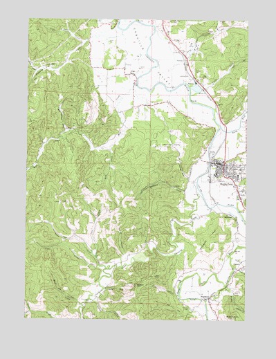
Myrtle Point, OR USGS Topographic Map
Click on map above to begin viewing in our Map Viewer.

This topographic map contains these locations and features:
Feature Name Type Latitude Longitude GNIS ID View Map
AragoPopulated PlaceN43.1021°W124.1923°1117024View Map
Arago Community ChurchChurchN43.1030°W124.1922°2508104View Map
Arago County Park Boat RampLocaleN43.0983°W124.1897°2058198View Map
Arago Post Office (historical)Post OfficeN43.1021°W124.1923°1164849View Map
BroadbentPopulated PlaceN43.0090°W124.1465°1118090View Map
Broadbent Post OfficeBuildingN43.0084°W124.1478°1164962View Map
Broadbent Post OfficePost OfficeN43.0087°W124.1480°2781554View Map
Broadbent School (historical)SchoolN43.0090°W124.1490°1638217View Map
Bryant Boat RampLocaleN43.0667°W124.1471°2668369View Map
C C Carter (historical)LocaleN43.0584°W124.1470°1166266View Map
Catching CreekStreamN43.0551°W124.1543°1118682View Map
Catching Creek CemeteryCemeteryN43.0077°W124.2143°1118683View Map
Cheney (historical)LocaleN43.0234°W124.1295°1136144View Map
Chicken GulchValleyN43.0129°W124.2059°1118886View Map
City of Myrtle PointCivilN43.0617°W124.1328°2411205View Map
Coal CreekStreamN43.0207°W124.2059°1119046View Map
Coos County Fair and RodeoLocaleN43.0593°W124.1452°1638190View Map
Coos County Fairgrounds MuseumBuildingN43.0602°W124.1438°2661453View Map
Coos County Fairgrounds Outdoor StageLocaleN43.0598°W124.1450°2661497View Map
Coos County Logging MuseumBuildingN43.0643°W124.1399°2661452View Map
Coos White Cedar Company (historical)LocaleN43.0740°W124.1401°1166269View Map
Coquille Fire Department Station 2BuildingN43.1033°W124.1966°2576826View Map
Coquille Fire Department Station 4BuildingN43.1208°W124.1736°2576878View Map
Coquille Watershed AssociationBuildingN43.1204°W124.1753°2709704View Map
Cove CreekStreamN43.0257°W124.2115°1119407View Map
Cribbins HillSummitN43.0284°W124.1485°1136192View Map
Elliott Post Office (historical)Post OfficeN43.0096°W124.2109°1164334View Map
EstabrookPopulated PlaceN43.0440°W124.1348°1166651View Map
Fishtrap CemeteryCemeteryN43.1231°W124.2026°1120788View Map
Fishtrap CreekStreamN43.1201°W124.1976°1120789View Map
Flora M Laird Memorial LibraryBuildingN43.0638°W124.1418°2661298View Map
Fort Kitchen (historical)LocaleN43.0454°W124.1451°1851690View Map
Four Bit GulchValleyN43.0590°W124.1593°1120912View Map
Gettys CreekStreamN43.0084°W124.2148°1121115View Map
Grady CreekStreamN43.0934°W124.1584°1121277View Map
Gray CreekStreamN43.1207°W124.1784°1121345View Map
Hall CreekStreamN43.0990°W124.1887°1121522View Map
Hall PrairieAreaN43.1054°W124.1971°1132153View Map
Hermann CemeteryCemeteryN43.0048°W124.1581°1121770View Map
Horse HollowValleyN43.0271°W124.1945°1122005View Map
Kausen CreekStreamN43.0512°W124.2471°1132154View Map
Knight CreekStreamN43.0029°W124.2479°1122814View Map
Lions Memorial ParkParkN43.0632°W124.1257°2058296View Map
Little Fishtrap CreekStreamN43.1143°W124.2193°1123196View Map
Llewellyn CreekStreamN43.0876°W124.1262°1123328View Map
Maple School (historical)SchoolN43.0637°W124.1373°1638208View Map
Marsters RockPillarN43.0140°W124.1882°1123798View Map
Matheny CreekStreamN43.0571°W124.1543°1123835View Map
Mineola (historical)LocaleN43.1129°W124.1665°1166280View Map
Myrtle Crest SchoolSchoolN43.0602°W124.1311°1124580View Map
Myrtle PointPopulated PlaceN43.0648°W124.1390°1124581View Map
Myrtle Point City HallBuildingN43.0639°W124.1424°2661462View Map
Myrtle Point Fire Department Station 1BuildingN43.0647°W124.1427°2576704View Map
Myrtle Point Fire Department Station 2BuildingN43.0086°W124.1473°2576876View Map
Myrtle Point High SchoolSchoolN43.0611°W124.1430°2416178View Map
Myrtle Point Log PondReservoirN43.0964°W124.1560°1135817View Map
Myrtle Point Municipal CourtBuildingN43.0639°W124.1424°2661030View Map
Myrtle Point Police DepartmentBuildingN43.0639°W124.1424°2737804View Map
Myrtle Point Post OfficeBuildingN43.0655°W124.1414°1165684View Map
Myrtle Point Post OfficePost OfficeN43.0656°W124.1414°2781556View Map
Myrtle Point Public WorksBuildingN43.0639°W124.1424°2661377View Map
Myrtle Point Sewage Treatment PlantLocaleN43.0695°W124.1471°2660699View Map
Myrtle Point Veneer Company Log DamDamN43.0965°W124.1545°1133621View Map
North Fork Coquille RiverStreamN43.0804°W124.1415°1124760View Map
NorwayPopulated PlaceN43.1009°W124.1568°1136583View Map
Norway Airstrip (historical)AirportN43.1026°W124.1609°1131671View Map
Norway CemeteryCemeteryN43.1038°W124.1569°1124855View Map
Norway Post OfficePost OfficeN43.1009°W124.1568°1165718View Map
Pleasant ValleyValleyN43.0821°W124.1729°1125480View Map
Rhoda CreekStreamN43.0140°W124.1373°1148403View Map
Rich CreekStreamN43.0707°W124.2043°1125976View Map
Robbins ButteSummitN43.0005°W124.1331°1126104View Map
Rock Robinson CreekStreamN43.0784°W124.2265°1126201View Map
Rollan CreekStreamN43.1029°W124.2459°1126266View Map
Rotary ParkParkN43.0607°W124.1379°2058297View Map
Saint James Lutheran ChurchChurchN43.0628°W124.1392°2508098View Map
South Fork Coquille RiverStreamN43.0804°W124.1415°1149958View Map
Sunset ParkParkN43.0553°W124.1291°2058298View Map
Upper Fishtrap CemeteryCemeteryN43.1054°W124.2358°1128451View Map
Ward CreekStreamN43.0223°W124.2095°1128632View Map
Warner CemeteryCemeteryN43.0248°W124.1293°1128659View Map
Warner CreekStreamN43.0215°W124.1332°1128662View Map
Wolf CreekStreamN43.0059°W124.2187°1129267View Map
York (historical)LocaleN43.0887°W124.1443°1166286View Map

Note: Coordinates in the location and feature list above are referenced to NAD83 datum.


Copyright (C) 2008-2024 Ryan Niemi / Sunset Dynamics ... All Rights Reserved