TopoQuest Logo
Do you find TopoQuest useful?
Help keep TopoQuest running and adding new maps/features by donating!
Bitcoin:  19c7KJd3qBynnjoSw5npx9KScwjBe4ifkT
Litecoin:  LXs6TkuXGGXo1vDsWCkWVdjQX94eUKd6ui
Home View Maps Find Maps Find Places Resources & Links


Belgrade Lakes, Maine Topographic Map

USGS Map Title: Belgrade Lakes, ME
USGS Map MRC: 44069E8
DRG (GeoTIFF) Download: o44069e8.tif


Neighboring USGS Topographic Map Quads:


  New Sharon, ME  
44070F1
 

  Mercer, ME  
44069F8
 

  Norridgewock, ME  
44069F7
 

  Farmington Falls, ME  
44070E1
 

  Belgrade Lakes, ME  
44069E8
 

  Rome, ME  
44069E7
 

  Fayette, ME  
44070D1
 

  Readfield, ME  
44069D8
 

  Belgrade, ME  
44069D7


Map MRC Location:

N45°
W70°
N45°
W69°
H8 H7 H6 H5 H4 H3 H2 H1
G8 G7 G6 G5 G4 G3 G2 G1
F8 F7 F6 F5 F4 F3 F2 F1
E8 E7 E6 E5 E4 E3 E2 E1
D8 D7 D6 D5 D4 D3 D2 D1
C8 C7 C6 C5 C4 C3 C2 C1
B8 B7 B6 B5 B4 B3 B2 B1
A8 A7 A6 A5 A4 A3 A2 A1
N44°
W70°
N44°
W69°

Belgrade Lakes, ME USGS 1:24K Topographic Map Preview:
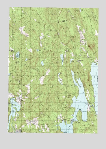
Belgrade Lakes, ME USGS Topographic Map
Click on map above to begin viewing in our Map Viewer.

This topographic map contains these locations and features:
Feature Name Type Latitude Longitude GNIS ID View Map
Beaver BrookStreamN44.5473°W69.9073°561894View Map
Beaver PondLakeN44.5511°W69.9274°561941View Map
Belgrade LakesPopulated PlaceN44.5265°W69.8870°562016View Map
Belgrade Lakes Post OfficePost OfficeN44.5290°W69.8879°2768966View Map
Belgrade Public LibraryBuildingN44.5192°W69.8777°2738489View Map
Belgrade Volunteer Fire Department Lakes StationBuildingN44.5225°W69.8821°2552818View Map
Berry HillSummitN44.5621°W69.9839°562085View Map
Big IslandIslandN44.5276°W69.9917°562188View Map
Blueberry HillSummitN44.5362°W69.9170°566599View Map
Boody PondLakeN44.5729°W69.9750°562744View Map
Castle IslandIslandN44.5120°W69.9092°563675View Map
Davis PondLakeN44.5579°W69.9987°564824View Map
Doloff PondLakeN44.5024°W69.9550°565203View Map
Dr Shaw Memorial LibraryBuildingN44.5014°W69.9875°2738331View Map
Flying PondReservoirN44.5228°W69.9920°566335View Map
Flying Pond DamDamN44.5149°W69.9930°1774067View Map
French MountainSummitN44.5710°W69.9181°566572View Map
Frink IslandIslandN44.5323°W69.9042°566600View Map
Great PondReservoirN44.5300°W69.8883°1773704View Map
Great Pond Outlet DamDamN44.5300°W69.8883°1773703View Map
Hampshire HillSummitN44.6174°W69.9404°567553View Map
Haynes Hovey CemeteryCemeteryN44.5014°W69.9775°2736724View Map
Hilton DamDamN44.5003°W69.9887°1774735View Map
Hoyt HillSummitN44.5729°W69.9930°568412View Map
John Brown MountainSummitN44.5478°W69.9759°568885View Map
Kidder PondLakeN44.5692°W69.9527°569154View Map
Kimball PondLakeN44.5775°W69.9872°569182View Map
Ladd PondLakeN44.6229°W69.9006°569297View Map
Long PointCapeN44.5467°W69.9014°570261View Map
Loon IslandIslandN44.5292°W69.9037°570362View Map
Martin HillSummitN44.5992°W69.9224°570847View Map
McGaffey MountainSummitN44.5290°W69.9597°570978View Map
McIntire PondLakeN44.5823°W69.9595°570992View Map
Mill PondReservoirN44.5357°W69.9842°1774730View Map
Mill Pond DamDamN44.5341°W69.9845°1774729View Map
Mill StreamStreamN44.5284°W69.9853°571355View Map
Morrill HillSummitN44.5960°W69.9087°571673View Map
Mount PhilipSummitN44.5867°W69.8850°573263View Map
Mount VernonPopulated PlaceN44.5012°W69.9876°571789View Map
Mount Vernon Airport (historical)AirportN44.5064°W69.9525°582188View Map
Mount Vernon Fire and Rescue Station 2BuildingN44.5013°W69.9858°2552942View Map
Mount Vernon Fire Department Station 1BuildingN44.5012°W69.9854°2552741View Map
Mount Vernon Post OfficePost OfficeN44.5011°W69.9870°2768935View Map
Pinewold PointCapeN44.5217°W69.9001°565421View Map
Ram IslandIslandN44.5690°W69.8773°569013View Map
Roberts HillSummitN44.5824°W69.9384°574301View Map
Rome CemeteryCemeteryN44.5886°W69.8999°2736765View Map
Rome CornerPopulated PlaceN44.5723°W69.9034°574443View Map
Rome Trout BrookStreamN44.5712°W69.8839°574444View Map
Rome Volunteer Fire Department Station 2BuildingN44.5782°W69.8997°2553212View Map
Round PondLakeN44.5586°W69.9290°574505View Map
Round TopSummitN44.5477°W69.9396°574534View Map
Sanders HillSummitN44.5700°W69.9340°574861View Map
Stony BrookStreamN44.5081°W69.9287°576395View Map
The MountainSummitN44.5530°W69.8906°576849View Map
Town of RomeCivilN44.5721°W69.8875°582700View Map
Trask CemeteryCemeteryN44.5462°W69.9186°2736778View Map
ViennaPopulated PlaceN44.5334°W69.9848°577718View Map
Vienna Fire StationBuildingN44.5359°W69.9853°2552763View Map
Vienna MountainSummitN44.5566°W69.9484°577720View Map
Vienna Post OfficePost OfficeN44.5350°W69.9853°2768974View Map
Vienna Town CemeteryCemeteryN44.5317°W69.9842°2736781View Map
Watson PondLakeN44.5743°W69.9253°577900View Map
Whittier BrookStreamN44.5628°W69.9139°578436View Map
Whittier PondLakeN44.5726°W69.9121°578441View Map
Whittier SchoolSchoolN44.5773°W69.9106°578443View Map
Yallaly HillSummitN44.5338°W69.9280°578736View Map
York HillSummitN44.5967°W69.9737°578777View Map

Note: Coordinates in the location and feature list above are referenced to NAD83 datum.


Copyright (C) 2008-2024 Ryan Niemi / Sunset Dynamics ... All Rights Reserved