TopoQuest Logo
Do you find TopoQuest useful?
Help keep TopoQuest running and adding new maps/features by donating!
Bitcoin:  19c7KJd3qBynnjoSw5npx9KScwjBe4ifkT
Litecoin:  LXs6TkuXGGXo1vDsWCkWVdjQX94eUKd6ui
Home View Maps Find Maps Find Places Resources & Links


Murphy Peak, Arizona Topographic Map

USGS Map Title: Murphy Peak, AZ
USGS Map MRC: 31111E2
DRG (GeoTIFF) Download: o31111e2.tif


Neighboring USGS Topographic Map Quads:


  Cerro Colorado, AZ  
31111F3
 

  Saucito Mountain, AZ  
31111F2
 

  Amado, AZ  
31111F1
 

  Arivaca, AZ  
31111E3
 

  Murphy Peak, AZ  
31111E2
 

  Tubac, AZ  
31111E1
 

  Bartlett Mountain, AZ  
31111D3
 

  Ruby, AZ  
31111D2
 

  Pena Blanca Lake, AZ  
31111D1


Map MRC Location:

N32°
W112°
N32°
W111°
H8 H7 H6 H5 H4 H3 H2 H1
G8 G7 G6 G5 G4 G3 G2 G1
F8 F7 F6 F5 F4 F3 F2 F1
E8 E7 E6 E5 E4 E3 E2 E1
D8 D7 D6 D5 D4 D3 D2 D1
C8 C7 C6 C5 C4 C3 C2 C1
B8 B7 B6 B5 B4 B3 B2 B1
A8 A7 A6 A5 A4 A3 A2 A1
N31°
W112°
N31°
W111°

Murphy Peak, AZ USGS 1:24K Topographic Map Preview:
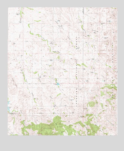
Murphy Peak, AZ USGS Topographic Map
Click on map above to begin viewing in our Map Viewer.

This topographic map contains these locations and features:
Feature Name Type Latitude Longitude GNIS ID View Map
Amole TankReservoirN31.5533°W111.1612°36522View Map
Apache CanyonValleyN31.5723°W111.2337°25695View Map
Apache PassGapN31.5076°W111.1951°25713View Map
Apache Pass DamDamN31.5034°W111.1893°36527View Map
Apache WellWellN31.5284°W111.1956°37144View Map
Bartolo CanyonValleyN31.5220°W111.2468°27407View Map
Bartolo MountainSummitN31.5095°W111.2040°26016View Map
Bear Grass TankReservoirN31.5504°W111.1931°37165View Map
Beehive DamDamN31.5095°W111.1615°36542View Map
Cajon TankReservoirN31.5221°W111.1772°37200View Map
Cedar DamDamN31.5737°W111.1743°27413View Map
Cedar WellWellN31.5818°W111.1965°27450View Map
Cedar WindmillWellN31.5895°W111.1990°37218View Map
Chapman TankReservoirN31.5851°W111.1719°37224View Map
Clifford WellWellN31.5773°W111.2351°27711View Map
Dicks PeakSummitN31.5259°W111.1623°28471View Map
Dicks Peak TankReservoirN31.5346°W111.1790°37273View Map
Diversion TankReservoirN31.5616°W111.1525°36609View Map
Dry DamDamN31.5912°W111.2293°37277View Map
East Fork Apache CanyonValleyN31.5584°W111.2120°28750View Map
Indian Hills TankReservoirN31.5952°W111.1403°14150View Map
Jalisco CanyonValleyN31.5723°W111.2340°30497View Map
Jalisco DamDamN31.5259°W111.2129°37357View Map
Jalisco RidgeRidgeN31.5479°W111.2423°30498View Map
Jalisco WellWellN31.5631°W111.2329°30499View Map
Lobo CanyonValleyN31.5618°W111.1523°31161View Map
Lobo TankReservoirN31.5535°W111.1412°36697View Map
Lower Sardina WellWellN31.6109°W111.1656°37384View Map
Middle Sardina DamDamN31.5979°W111.1598°36723View Map
Midway TankReservoirN31.5576°W111.2098°37405View Map
Midway WellWellN31.5568°W111.2143°37406View Map
Moyza TankReservoirN31.6116°W111.1931°37420View Map
Moyza WellWellN31.6068°W111.1898°32089View Map
Murphy CanyonValleyN31.5823°W111.2320°32199View Map
Murphy PeakSummitN31.5184°W111.1643°32200View Map
Murphy WellWellN31.5445°W111.1681°32206View Map
Noon TankReservoirN31.5288°W111.1855°37434View Map
Papalote TankReservoirN31.6182°W111.2376°37463View Map
Papalote WellWellN31.6104°W111.2348°32667View Map
Red Hill TankReservoirN31.5731°W111.1989°37485View Map
Red SpringSpringN31.6003°W111.1522°33513View Map
Red Spring PassGapN31.6026°W111.1506°33514View Map
Red Spring TankReservoirN31.6087°W111.1441°36802View Map
Sardina DamDamN31.5743°W111.1520°36834View Map
Sardina WellWellN31.5740°W111.1518°34085View Map
Turtle SpringSpringN31.5100°W111.1298°41813View Map
Twin PeaksSummitN31.5898°W111.2443°35623View Map
Upper Puerto TankReservoirN31.6114°W111.1325°36892View Map
White TankReservoirN31.5650°W111.1640°36908View Map

Note: Coordinates in the location and feature list above are referenced to NAD83 datum.


Copyright (C) 2008-2024 Ryan Niemi / Sunset Dynamics ... All Rights Reserved