TopoQuest Logo
Do you find TopoQuest useful?
Help keep TopoQuest running and adding new maps/features by donating!
Bitcoin:  19c7KJd3qBynnjoSw5npx9KScwjBe4ifkT
Litecoin:  LXs6TkuXGGXo1vDsWCkWVdjQX94eUKd6ui
Home View Maps Find Maps Find Places Resources & Links


Munds Mountain, Arizona Topographic Map

USGS Map Title: Munds Mountain, AZ
USGS Map MRC: 34111G6
DRG (GeoTIFF) Download: o34111g6.tif


Neighboring USGS Topographic Map Quads:


  Wilson Mountain, AZ  
34111H7
 

  Munds Park, AZ  
34111H6
 

  Mormon Mountain, AZ  
34111H5
 

  Sedona, AZ  
34111G7
 

  Munds Mountain, AZ  
34111G6
 

  Stoneman Lake, AZ  
34111G5
 

  Lake Montezuma, AZ  
34111F7
 

  Casner Butte, AZ  
34111F6
 

  Apache Maid Mountain, AZ  
34111F5


Map MRC Location:

N35°
W112°
N35°
W111°
H8 H7 H6 H5 H4 H3 H2 H1
G8 G7 G6 G5 G4 G3 G2 G1
F8 F7 F6 F5 F4 F3 F2 F1
E8 E7 E6 E5 E4 E3 E2 E1
D8 D7 D6 D5 D4 D3 D2 D1
C8 C7 C6 C5 C4 C3 C2 C1
B8 B7 B6 B5 B4 B3 B2 B1
A8 A7 A6 A5 A4 A3 A2 A1
N34°
W112°
N34°
W111°

Munds Mountain, AZ USGS 1:24K Topographic Map Preview:
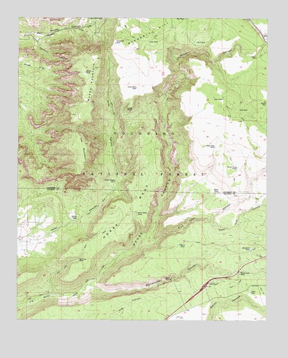
Munds Mountain, AZ USGS Topographic Map
Click on map above to begin viewing in our Map Viewer.

This topographic map contains these locations and features:
Feature Name Type Latitude Longitude GNIS ID View Map
Basin TankReservoirN34.8032°W111.6499°26025View Map
Bear TankReservoirN34.8372°W111.6569°2090377View Map
Beaver TankReservoirN34.7506°W111.7454°41352View Map
Cat TankReservoirN34.8375°W111.6394°27355View Map
Cedar TankReservoirN34.7618°W111.6335°27445View Map
Cedar TankReservoirN34.7961°W111.6338°41240View Map
Cedar Tank CanyonValleyN34.7911°W111.6535°27448View Map
Committee TankReservoirN34.8647°W111.7019°27834View Map
Cons TankReservoirN34.8415°W111.6481°27858View Map
County Line TankReservoirN34.8106°W111.6639°2090375View Map
Coyote Pup TankReservoirN34.8219°W111.6518°28121View Map
Cub TankReservoirN34.8497°W111.6564°2090378View Map
Damfino CanyonValleyN34.8684°W111.7429°28255View Map
Dutchs TankReservoirN34.8400°W111.6260°28705View Map
H A TankReservoirN34.8650°W111.6612°29640View Map
Horse MesaSummitN34.7939°W111.6943°30148View Map
Horse Mesa TankReservoirN34.7943°W111.6911°30151View Map
Horse TankReservoirN34.7812°W111.6691°30171View Map
Horse Trap TankReservoirN34.8132°W111.6406°30182View Map
Hot Loop TankReservoirN34.7753°W111.7196°30224View Map
Hot Loop TrailTrailN34.7820°W111.7154°30225View Map
Jack Canyon-Munds Mountain Fifty Five - Seventy SevenTrailN34.8334°W111.7021°37851View Map
Jacks Canyon TankReservoirN34.8076°W111.7016°30473View Map
Jacks PointCliffN34.8370°W111.6952°30475View Map
Jacks Point TankReservoirN34.8460°W111.6911°30476View Map
Lee MountainSummitN34.8228°W111.7171°30928View Map
Lee Mountain SpringSpringN34.8068°W111.7162°37897View Map
Lower Rattlesnake TankReservoirN34.7709°W111.6660°38595View Map
Merry-Go-RoundSummitN34.8747°W111.7082°31719View Map
Munds MountainSummitN34.8584°W111.7113°32191View Map
Munds Mountain WildernessReserveN34.8191°W111.7054°44735View Map
Munds TankReservoirN34.8525°W111.7168°32196View Map
Natural TankReservoirN34.7800°W111.6777°38656View Map
Oak TankReservoirN34.8652°W111.6851°32470View Map
Pine Tank CanyonValleyN34.7847°W111.6863°32984View Map
Rattlesnake CanyonValleyN34.7647°W111.7140°33394View Map
Rattlesnake TankReservoirN34.7700°W111.6386°33409View Map
Ridge TankReservoirN34.8197°W111.6333°2090376View Map
Robbers RoostLocaleN34.8586°W111.6310°33669View Map
Sheeptrail TankReservoirN34.7792°W111.6335°34361View Map
Skeleton TankReservoirN34.7947°W111.6732°41353View Map
Speeds TankReservoirN34.7922°W111.7234°34703View Map
Stoneman Lake InterchangeCrossingN34.7645°W111.6565°34874View Map
Upper Rattlesnake TankReservoirN34.7746°W111.6627°38909View Map
Woods CanyonValleyN34.7650°W111.7152°36381View Map
Woods Canyon BridgeBridgeN34.8653°W111.6263°38193View Map
Woods RanchLocaleN34.8672°W111.6257°36386View Map

Note: Coordinates in the location and feature list above are referenced to NAD83 datum.


Copyright (C) 2008-2024 Ryan Niemi / Sunset Dynamics ... All Rights Reserved