TopoQuest Logo
Do you find TopoQuest useful?
Help keep TopoQuest running and adding new maps/features by donating!
Bitcoin:  19c7KJd3qBynnjoSw5npx9KScwjBe4ifkT
Litecoin:  LXs6TkuXGGXo1vDsWCkWVdjQX94eUKd6ui
Home View Maps Find Maps Find Places Resources & Links


Muncie West, Indiana Topographic Map

USGS Map Title: Muncie West, IN
USGS Map MRC: 40085B4
DRG (GeoTIFF) Download: o40085b4.tif


Neighboring USGS Topographic Map Quads:


  Gaston, IN  
40085C5
 

  Wheeling, IN  
40085C4
 

  Eaton, IN  
40085C3
 

  Gilman, IN  
40085B5
 

  Muncie West, IN  
40085B4
 

  Muncie East, IN  
40085B3
 

  Middletown, IN  
40085A5
 

  Sulphur Springs, IN  
40085A4
 

  Mount Pleasant, IN  
40085A3


Map MRC Location:

N41°
W86°
N41°
W85°
H8 H7 H6 H5 H4 H3 H2 H1
G8 G7 G6 G5 G4 G3 G2 G1
F8 F7 F6 F5 F4 F3 F2 F1
E8 E7 E6 E5 E4 E3 E2 E1
D8 D7 D6 D5 D4 D3 D2 D1
C8 C7 C6 C5 C4 C3 C2 C1
B8 B7 B6 B5 B4 B3 B2 B1
A8 A7 A6 A5 A4 A3 A2 A1
N40°
W86°
N40°
W85°

Muncie West, IN USGS 1:24K Topographic Map Preview:
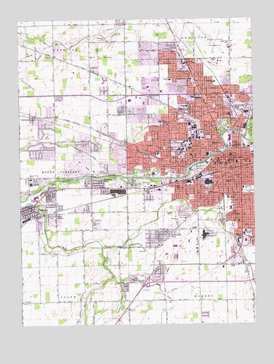
Muncie West, IN USGS Topographic Map
Click on map above to begin viewing in our Map Viewer.

This topographic map contains these locations and features:
Feature Name Type Latitude Longitude GNIS ID View Map
AndersonvillePopulated PlaceN40.2187°W85.4311°430166View Map
Anthony Elementary SchoolSchoolN40.2145°W85.4105°430194View Map
Antioch ChurchChurchN40.2350°W85.4814°430213View Map
Ball State UniversitySchoolN40.1995°W85.4125°449616View Map
Ball State University Police DepartmentBuildingN40.1950°W85.4075°2758239View Map
Beech Grove CemeteryCemeteryN40.1892°W85.4033°430723View Map
Bell CreekStreamN40.1570°W85.4569°430762View Map
Bradford ParkParkN40.1834°W85.4583°431437View Map
Burris SchoolSchoolN40.1970°W85.4125°431872View Map
CammackPopulated PlaceN40.2098°W85.4925°432004View Map
Carroll's AirparkAirportN40.1277°W85.4411°2677101View Map
Center Township Emergency Services Station 12BuildingN40.2242°W85.4397°2626117View Map
Center Township Emergency Services Station 13BuildingN40.1578°W85.4095°2719286View Map
Central High SchoolSchoolN40.1917°W85.3886°432357View Map
City of MuncieCivilN40.1989°W85.3950°2395138View Map
Corinth ChurchChurchN40.1350°W85.4239°432968View Map
Cowing ParkParkN40.2142°W85.3958°433058View Map
Delaware CountyCivilN40.2275°W85.3969°450347View Map
Delaware County Airport Authority Fire DepartmentBuildingN40.2403°W85.3893°2626469View Map
Delaware County Emergency Medical ServicesBuildingN40.1925°W85.3826°2719288View Map
Delaware County Regional AirportAirportN40.2403°W85.3912°449277View Map
Delaware County Sheriff's DepartmentBuildingN40.1943°W85.3871°2758137View Map
DrewPopulated PlaceN40.2189°W85.3869°433686View Map
Eagle BranchStreamN40.2428°W85.4636°433835View Map
Elm Ridge Memorial ParkCemeteryN40.1820°W85.4416°434124View Map
Emerson SchoolSchoolN40.1992°W85.3961°434158View Map
Field SchoolSchoolN40.1687°W85.4122°434474View Map
Forest Park Elementary SchoolSchoolN40.1817°W85.4158°434665View Map
Garfield Elementary SchoolSchoolN40.1806°W85.3808°434960View Map
Guthrie ParkParkN40.1973°W85.4227°435563View Map
Harrison SchoolSchoolN40.1834°W85.3897°435800View Map
Heath DitchCanalN40.1581°W85.4386°435954View Map
Heekin ParkParkN40.1792°W85.3772°435979View Map
Indiana University Ball Memorial HospitalHospitalN40.1971°W85.4144°430459View Map
Jefferson SchoolSchoolN40.1928°W85.3939°436971View Map
John B And June M Scheumann StadiumLocaleN40.2158°W85.4167°2555875View Map
Lincoln SchoolSchoolN40.1792°W85.4011°437929View Map
Little No Name CreekStreamN40.1425°W85.4477°438105View Map
McCulloch ParkParkN40.2039°W85.3752°438834View Map
McKinley CemeteryCemeteryN40.1989°W85.4705°438897View Map
McKinley High SchoolSchoolN40.1981°W85.3847°438899View Map
McKinley Middle SchoolSchoolN40.1989°W85.3872°438900View Map
Memorial ChurchChurchN40.1684°W85.4169°438984View Map
Meridian ServicesBuildingN40.1952°W85.4188°2660541View Map
Middletown ParkPopulated PlaceN40.1623°W85.4247°439119View Map
Mitchell Elementary SchoolSchoolN40.2256°W85.4189°439297View Map
Morrison Mock Elementary SchoolSchoolN40.1873°W85.4291°439464View Map
Mount Olive ChurchChurchN40.2350°W85.4619°439628View Map
Mount Pleasant - Yorktown Fire DepartmentBuildingN40.1750°W85.4899°2625584View Map
Mount Zion ChurchChurchN40.1387°W85.4386°439767View Map
MunciePopulated PlaceN40.1934°W85.3864°439878View Map
Muncie CreekStreamN40.2009°W85.3797°439879View Map
Muncie Fire DepartmentBuildingN40.1925°W85.3820°2625895View Map
Muncie MallLocaleN40.2209°W85.3752°449402View Map
Muncie Police DepartmentBuildingN40.1957°W85.3870°2758156View Map
No Name CreekStreamN40.1448°W85.4514°440187View Map
North View Elementary SchoolSchoolN40.2242°W85.3952°440311View Map
Northside High SchoolSchoolN40.2131°W85.4127°440341View Map
Northwest Plaza Shopping CenterLocaleN40.2178°W85.4061°452373View Map
Northwest Plaza Shopping CenterLocaleN40.2173°W85.4055°449403View Map
Nottingham CemeteryCemeteryN40.2373°W85.4764°440361View Map
Pleasant View Elementary SchoolSchoolN40.1850°W85.4939°441350View Map
Renaissance Specialty Hospital of Central IndianaBuildingN40.2179°W85.4255°2660525View Map
Riggins DitchCanalN40.2381°W85.4150°449526View Map
Riley Elementary SchoolSchoolN40.2109°W85.3877°442033View Map
Roosevelt SchoolSchoolN40.1698°W85.3836°442278View Map
Rose ParkParkN40.1809°W85.3991°442298View Map
Saint Andrews ChurchChurchN40.2378°W85.4177°442469View Map
Saint Mary SchoolSchoolN40.1950°W85.4144°442713View Map
Southside ChurchChurchN40.1500°W85.4264°443884View Map
Southway PlazaLocaleN40.1612°W85.3839°449401View Map
Storer Middle SchoolSchoolN40.2084°W85.4255°444236View Map
Temple ChurchChurchN40.1609°W85.3830°444628View Map
Thomas ParkParkN40.1770°W85.4089°444696View Map
Tomlinson CemeteryCemeteryN40.1451°W85.4332°444810View Map
Township of CenterCivilN40.1913°W85.3862°453176View Map
Tuhey ParkParkN40.1964°W85.3914°444944View Map
Washington-Carver Community Elementary SchoolSchoolN40.1917°W85.3791°445513View Map
WBST-FM (Muncie)TowerN40.2134°W85.4600°448989View Map
WBST-FM (Muncie)TowerN40.2014°W85.4230°448991View Map
West MunciePopulated PlaceN40.1709°W85.4814°445793View Map
West View Elementary SchoolSchoolN40.1950°W85.4261°445823View Map
Westside ChurchChurchN40.1709°W85.4222°445860View Map
Westside ParkParkN40.1859°W85.4155°445862View Map
Wilson Middle SchoolSchoolN40.1767°W85.3894°446158View Map
WIPB-TV (Muncie)TowerN40.1606°W85.3783°446993View Map
WLBC-AM (Muncie)TowerN40.1617°W85.3780°448437View Map
WLBC-FM (Muncie)TowerN40.1606°W85.3783°448988View Map
WWHI-FM (Muncie)TowerN40.1625°W85.3791°448990View Map
YorktownPopulated PlaceN40.1737°W85.4941°446404View Map
Yorktown High SchoolSchoolN40.1831°W85.4939°446406View Map
Yorktown Middle SchoolSchoolN40.1773°W85.4916°446634View Map
Yorktown Police DepartmentBuildingN40.1716°W85.4833°2758476View Map

Note: Coordinates in the location and feature list above are referenced to NAD83 datum.


Copyright (C) 2008-2024 Ryan Niemi / Sunset Dynamics ... All Rights Reserved