TopoQuest Logo
Do you find TopoQuest useful?
Help keep TopoQuest running and adding new maps/features by donating!
Bitcoin:  19c7KJd3qBynnjoSw5npx9KScwjBe4ifkT
Litecoin:  LXs6TkuXGGXo1vDsWCkWVdjQX94eUKd6ui
Home View Maps Find Maps Find Places Resources & Links


Mummy Cave Ruins, Arizona Topographic Map

USGS Map Title: Mummy Cave Ruins, AZ
USGS Map MRC: 36109B3
DRG (GeoTIFF) Download: o36109b3.tif


Neighboring USGS Topographic Map Quads:


  Tall Tree Mesa, AZ  
36109C4
 

  Red Cornfield Mesa, AZ  
36109C3
 

  Tsaile, AZ  
36109C2
 

  Del Muerto, AZ  
36109B4
 

  Mummy Cave Ruins, AZ  
36109B3
 

  Lower Wheatfields, AZ  
36109B2
 

  Three Turkey Canyon, AZ  
36109A4
 

  Spider Rock, AZ  
36109A3
 

  White Clay, AZ  
36109A2


Map MRC Location:

N37°
W110°
N37°
W109°
H8 H7 H6 H5 H4 H3 H2 H1
G8 G7 G6 G5 G4 G3 G2 G1
F8 F7 F6 F5 F4 F3 F2 F1
E8 E7 E6 E5 E4 E3 E2 E1
D8 D7 D6 D5 D4 D3 D2 D1
C8 C7 C6 C5 C4 C3 C2 C1
B8 B7 B6 B5 B4 B3 B2 B1
A8 A7 A6 A5 A4 A3 A2 A1
N36°
W110°
N36°
W109°

Mummy Cave Ruins, AZ USGS 1:24K Topographic Map Preview:
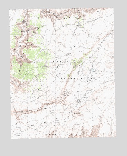
Mummy Cave Ruins, AZ USGS Topographic Map
Click on map above to begin viewing in our Map Viewer.

This topographic map contains these locations and features:
Feature Name Type Latitude Longitude GNIS ID View Map
Ata DeezaSummitN36.1478°W109.2957°21515View Map
Bear SpringSpringN36.1941°W109.2966°1142View Map
Big Cave RuinsLocaleN36.2108°W109.3707°1300View Map
Big FlowFallsN36.2358°W109.3229°1315View Map
Black Rock ButteSummitN36.1481°W109.2955°1593View Map
Black Rock SpringSpringN36.1667°W109.3090°21538View Map
Black Rock TrailTrailN36.1250°W109.3287°1614View Map
Black Wood HillSummitN36.1922°W109.2820°1639View Map
Fir Tree CanyonValleyN36.2047°W109.3651°4607View Map
Frozen Feet WindmillWellN36.2058°W109.3073°21633View Map
Garden DamDamN36.1708°W109.2790°21641View Map
Giant CanyonValleyN36.2075°W109.3665°5001View Map
Little Middle MesaSummitN36.2011°W109.3049°21681View Map
Massacre Cave OverlookLocaleN36.2383°W109.3595°21699View Map
Mummy Cave OverlookLocaleN36.2278°W109.3576°39092View Map
Mummy Cave RuinsLocaleN36.2325°W109.3562°42957View Map
Ndishchii NaatiAreaN36.2006°W109.2757°8550View Map
Peninsula WindmillWellN36.1283°W109.3679°21738View Map
Poison Ivy CanyonValleyN36.2492°W109.2937°9608View Map
Red Clay TrailTrailN36.1378°W109.2954°10033View Map
Sagebrush DamDamN36.1632°W109.2848°21792View Map
Sheep PointCliffN36.2189°W109.3548°11190View Map
Sheep Point CanyonValleyN36.2153°W109.3620°11191View Map
Spanish TrailTrailN36.2386°W109.3165°11661View Map
Tseh-Ya-Kin CanyonValleyN36.2275°W109.3576°12781View Map
Twin DamsDamN36.1603°W109.2954°21865View Map
White ButteSummitN36.1951°W109.2542°21884View Map
Yucca Cave RuinsLocaleN36.2372°W109.3601°21908View Map

Note: Coordinates in the location and feature list above are referenced to NAD83 datum.


Copyright (C) 2008-2024 Ryan Niemi / Sunset Dynamics ... All Rights Reserved