TopoQuest Logo
Do you find TopoQuest useful?
Help keep TopoQuest running and adding new maps/features by donating!
Bitcoin:  19c7KJd3qBynnjoSw5npx9KScwjBe4ifkT
Litecoin:  LXs6TkuXGGXo1vDsWCkWVdjQX94eUKd6ui
Home View Maps Find Maps Find Places Resources & Links


Mud Lake, Arkansas Topographic Map

USGS Map Title: Mud Lake, AR
USGS Map MRC: 34090H5
DRG (GeoTIFF) Download: o34090h5.tif


Neighboring USGS Topographic Map Quads:


  Madison, AR  
35090A6
 

  Round Pond, AR  
35090A5
 

  Chatfield, AR  
35090A4
 

  Dansby, AR  
34090H6
 

  Mud Lake, AR  
34090H5
 

  Hughes, AR  
34090H4
 

  Soudan, AR  
34090G6
 

  Brickeys, AR  
34090G5
 

  Council, AR  
34090G4


Map MRC Location:

N35°
W91°
N35°
W90°
H8 H7 H6 H5 H4 H3 H2 H1
G8 G7 G6 G5 G4 G3 G2 G1
F8 F7 F6 F5 F4 F3 F2 F1
E8 E7 E6 E5 E4 E3 E2 E1
D8 D7 D6 D5 D4 D3 D2 D1
C8 C7 C6 C5 C4 C3 C2 C1
B8 B7 B6 B5 B4 B3 B2 B1
A8 A7 A6 A5 A4 A3 A2 A1
N34°
W91°
N34°
W90°

Mud Lake, AR USGS 1:24K Topographic Map Preview:
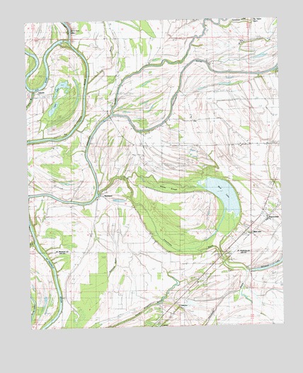
Mud Lake, AR USGS Topographic Map
Click on map above to begin viewing in our Map Viewer.

This topographic map contains these locations and features:
Feature Name Type Latitude Longitude GNIS ID View Map
Bethlehem CemeteryCemeteryN34.8754°W90.5690°59528View Map
Big LakeLakeN34.9735°W90.6077°83078View Map
Big Rabbit BayouStreamN34.9973°W90.5290°83079View Map
BledsoePopulated PlaceN34.9054°W90.5243°83086View Map
Burnt Cane BendBendN34.9926°W90.6059°82920View Map
Burnt Cane CrossingPopulated PlaceN34.9901°W90.6143°83092View Map
Burnt Cane ShoalBarN34.9912°W90.6093°83094View Map
Corner Stone ChurchChurchN34.9637°W90.6182°83109View Map
Cornerstone Church (historical)ChurchN34.9926°W90.5820°82924View Map
Council BarBarN34.9543°W90.6098°83111View Map
Cup BayouGutN34.9773°W90.5901°83116View Map
Cut-Off Ferry (historical)CrossingN34.9098°W90.6215°83049View Map
Cut-off School (historical)SchoolN34.8962°W90.6073°59530View Map
Donahue LakeLakeN34.9988°W90.5179°83139View Map
EblingPopulated PlaceN34.9084°W90.6232°83037View Map
Fifteenmile BayouStreamN34.9612°W90.5834°83146View Map
Frenchman BayouGutN34.9065°W90.5512°83155View Map
Gospel TempleChurchN34.8937°W90.5379°49521View Map
Green FarmLocaleN34.9904°W90.5182°82926View Map
Green School (historical)SchoolN34.9915°W90.5043°82927View Map
Horseshoe BendBendN34.9726°W90.6196°83175View Map
Kingsley CrossingPopulated PlaceN34.9765°W90.6154°83186View Map
KokomoPopulated PlaceN34.8820°W90.5495°58028View Map
LakesidePopulated PlaceN34.9701°W90.6223°83192View Map
Linder IslandIslandN34.9543°W90.5834°82930View Map
Linders Mill (historical)Populated PlaceN34.9931°W90.5854°83030View Map
Locust Grove CemeteryCemeteryN34.9543°W90.5654°82931View Map
Locust Grove ChurchChurchN34.9537°W90.5659°83202View Map
Locust Grove School (historical)SchoolN34.9540°W90.5662°83050View Map
Millseed LakeLakeN34.8995°W90.5040°83061View Map
Mound School (historical)SchoolN34.8757°W90.5695°59529View Map
Mount Zion ChurchChurchN34.8840°W90.5515°52474View Map
Mount Zion Church (historical)ChurchN34.9598°W90.5543°83052View Map
Mud LakeLakeN34.9283°W90.5288°83224View Map
Mud LakePopulated PlaceN34.9123°W90.5140°83225View Map
Pleasant Grove School (historical)SchoolN34.9354°W90.5793°83055View Map
Pleasant Plain ChurchChurchN34.9354°W90.5790°82937View Map
RawlinsonPopulated PlaceN34.9293°W90.5898°83255View Map
Robinson Ferry (historical)CrossingN34.9584°W90.5990°83058View Map
Rollison Church (historical)ChurchN34.9276°W90.5904°82948View Map
Rollison School (historical)SchoolN34.9284°W90.5882°83059View Map
Section School (historical)SchoolN34.9537°W90.5682°82952View Map
ShannondalePopulated PlaceN34.9193°W90.5076°83280View Map
Shepperd CrossingPopulated PlaceN34.9879°W90.6004°83284View Map
Township of Black FishCivilN34.9470°W90.5668°82856View Map
Twin Bridge School (historical)SchoolN34.9623°W90.5854°82957View Map
Walling BarBarN34.8845°W90.6104°55989View Map
Willbo SloughGutN34.9315°W90.5557°82960View Map
WinonaPopulated PlaceN34.8973°W90.5337°59527View Map

Note: Coordinates in the location and feature list above are referenced to NAD83 datum.


Copyright (C) 2008-2024 Ryan Niemi / Sunset Dynamics ... All Rights Reserved