TopoQuest Logo
Do you find TopoQuest useful?
Help keep TopoQuest running and adding new maps/features by donating!
Bitcoin:  19c7KJd3qBynnjoSw5npx9KScwjBe4ifkT
Litecoin:  LXs6TkuXGGXo1vDsWCkWVdjQX94eUKd6ui
Home View Maps Find Maps Find Places Resources & Links


Moyock, North Carolina Topographic Map

USGS Map Title: Moyock, NC
USGS Map MRC: 36076E2
DRG (GeoTIFF) Download: o36076e2.tif


Neighboring USGS Topographic Map Quads:


  Fentress, VA  
36076F2
 

  Pleasant Ridge, VA  
36076F1


  Moyock, NC  
36076E2
 

  Creeds, VA  
36076E1
 

  South Mills, NC  
36076D3
 

  Lambs Corner, NC  
36076D2
 

  Currituck, NC  
36076D1


Map MRC Location:

N37°
W77°
N37°
W76°
H8 H7 H6 H5 H4 H3 H2 H1
G8 G7 G6 G5 G4 G3 G2 G1
F8 F7 F6 F5 F4 F3 F2 F1
E8 E7 E6 E5 E4 E3 E2 E1
D8 D7 D6 D5 D4 D3 D2 D1
C8 C7 C6 C5 C4 C3 C2 C1
B8 B7 B6 B5 B4 B3 B2 B1
A8 A7 A6 A5 A4 A3 A2 A1
N36°
W77°
N36°
W76°

Moyock, NC USGS 1:24K Topographic Map Preview:
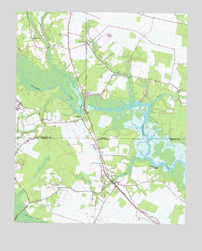
Moyock, NC USGS Topographic Map
Click on map above to begin viewing in our Map Viewer.

This topographic map contains these locations and features:
Feature Name Type Latitude Longitude GNIS ID View Map
ArringdalePopulated PlaceN36.5313°W76.1841°1002460View Map
Carolina Village Mobile Home ParkPopulated PlaceN36.5338°W76.2476°2505425View Map
Chesapeake Fire Department Station 7 Saint BridesBuildingN36.6062°W76.2109°2075508View Map
Currituck County Fire and Emergency Medical Services Station 3 MoyockBuildingN36.5236°W76.1743°2639224View Map
Indian CreekStreamN36.5724°W76.1622°1478811View Map
Indian Creek ChurchChurchN36.5888°W76.1755°1478812View Map
Indian Creek Correctional CenterBuildingN36.6157°W76.1805°2519583View Map
Light SwampSwampN36.5260°W76.2335°988473View Map
Middlewoods Mobile Home ParkPopulated PlaceN36.5494°W76.2366°2505527View Map
MorsePopulated PlaceN36.5185°W76.1663°1002459View Map
MoyockPopulated PlaceN36.5246°W76.1783°990736View Map
Moyock CemeteryCemeteryN36.5446°W76.1894°990737View Map
Moyock Census Designated PlaceCensusN36.5165°W76.1728°2628646View Map
Moyock Elementary SchoolSchoolN36.5247°W76.1742°1002452View Map
Moyock Fire Department and Rescue SquadBuildingN36.5235°W76.1744°2638532View Map
Moyock Middle SchoolSchoolN36.5027°W76.1570°2076392View Map
Moyock Post OfficePost OfficeN36.5213°W76.1752°2774092View Map
NorthwestPopulated PlaceN36.5615°W76.2010°1496021View Map
Northwest CemeteryCemeteryN36.5605°W76.2256°1479226View Map
Northwest ChurchChurchN36.5604°W76.2308°1479227View Map
Northwest Post OfficePost OfficeN36.5618°W76.2002°1780073View Map
Northwest Radio Post OfficePost OfficeN36.5671°W76.2472°2768401View Map
Northwest River Marsh Wildlife AreaAreaN36.5418°W76.1391°1002458View Map
Northwest River ParkParkN36.5796°W76.1538°1780074View Map
Panther LandingPopulated PlaceN36.5340°W76.1488°1021798View Map
Pleasant Grove ChurchChurchN36.6113°W76.2124°1479342View Map
Providence Swamp (historical)SwampN36.5229°W76.2374°1002408View Map
Saint BridesPopulated PlaceN36.6065°W76.1974°1479488View Map
Saint Brides Correctional CenterBuildingN36.6117°W76.1846°2767191View Map
Saint Brides Correctional CenterBuildingN36.6115°W76.1824°1780079View Map
Shingle Landing CreekStreamN36.5357°W76.1549°990738View Map
Smith CreekStreamN36.5715°W76.1513°1479639View Map
Township of MoyockCivilN36.5100°W76.1561°1026607View Map
Virginia Department of Correctional Education - Indian Creek Correctional CenterSchoolN36.6145°W76.1784°2465411View Map
Virginia Department of Correctional Education - Saint Brides Correctional CenterSchoolN36.6115°W76.1819°2465412View Map
Willow Grove ChurchChurchN36.6079°W76.2374°1479899View Map

Note: Coordinates in the location and feature list above are referenced to NAD83 datum.


Copyright (C) 2008-2024 Ryan Niemi / Sunset Dynamics ... All Rights Reserved