TopoQuest Logo
Do you find TopoQuest useful?
Help keep TopoQuest running and adding new maps/features by donating!
Bitcoin:  19c7KJd3qBynnjoSw5npx9KScwjBe4ifkT
Litecoin:  LXs6TkuXGGXo1vDsWCkWVdjQX94eUKd6ui
Home View Maps Find Maps Find Places Resources & Links


Mount Sidney, Virginia Topographic Map

USGS Map Title: Mount Sidney, VA
USGS Map MRC: 38078C8
DRG (GeoTIFF) Download: o38078c8.tif


Neighboring USGS Topographic Map Quads:


  Briery Branch, VA  
38079D1
 

  Bridgewater, VA  
38078D8
 

  Harrisonburg, VA  
38078D7
 

  Parnassus, VA  
38079C1
 

  Mount Sidney, VA  
38078C8
 

  Grottoes, VA  
38078C7
 

  Staunton, VA  
38079B1
 

  Fort Defiance, VA  
38078B8
 

  Crimora, VA  
38078B7


Map MRC Location:

N39°
W79°
N39°
W78°
H8 H7 H6 H5 H4 H3 H2 H1
G8 G7 G6 G5 G4 G3 G2 G1
F8 F7 F6 F5 F4 F3 F2 F1
E8 E7 E6 E5 E4 E3 E2 E1
D8 D7 D6 D5 D4 D3 D2 D1
C8 C7 C6 C5 C4 C3 C2 C1
B8 B7 B6 B5 B4 B3 B2 B1
A8 A7 A6 A5 A4 A3 A2 A1
N38°
W79°
N38°
W78°

Mount Sidney, VA USGS 1:24K Topographic Map Preview:
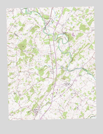
Mount Sidney, VA USGS Topographic Map
Click on map above to begin viewing in our Map Viewer.

This topographic map contains these locations and features:
Feature Name Type Latitude Longitude GNIS ID View Map
Augusta County Sheriff's Office Weyers CaveBuildingN38.2631°W78.9006°2767000View Map
Bells CemeteryCemeteryN38.2615°W78.9553°1463051View Map
Bethany ChurchChurchN38.3012°W78.9350°1463147View Map
Blacks RunStreamN38.3723°W78.9325°1481839View Map
Blue Ridge Community CollegeSchoolN38.2790°W78.9375°1739585View Map
Bridgewater Air ParkAirportN38.3646°W78.9597°1498597View Map
BurketownPopulated PlaceN38.3029°W78.9345°1495337View Map
Byers BranchStreamN38.3065°W78.9300°1464202View Map
Cash CemeteryCemeteryN38.2654°W78.8981°1464517View Map
Click CemeteryCemeteryN38.2851°W78.9125°1464983View Map
College StablesBuildingN38.3750°W78.9683°2082308View Map
Cooks CreekStreamN38.3457°W78.9386°1477959View Map
Cornerstone Christian SchoolSchoolN38.3704°W78.9488°2497749View Map
Faith Bible Christian AcademySchoolN38.3260°W78.9380°2497760View Map
FriedensPopulated PlaceN38.3496°W78.8761°1779322View Map
Friedens ChurchChurchN38.3485°W78.8761°1466888View Map
Goose CreekStreamN38.3026°W78.9698°1467251View Map
Interchange 235CrossingN38.2885°W78.9334°1739628View Map
Interchange 240CrossingN38.3571°W78.9273°1779326View Map
Landes CemeteryCemeteryN38.3012°W78.9714°1469119View Map
Long Glade CreekStreamN38.3685°W78.9709°1469811View Map
Melanchthon ChapelChurchN38.2982°W78.8986°1470348View Map
Melanchthon Lutheran Chapel CemeteryCemeteryN38.2990°W78.8986°1953188View Map
Mooreland FarmsLocaleN38.2664°W78.9725°2675428View Map
Mount CrawfordPopulated PlaceN38.3571°W78.9409°1495970View Map
Mount Crawford Post OfficePost OfficeN38.3583°W78.9407°1779333View Map
Mount SidneyPopulated PlaceN38.2574°W78.9595°1495974View Map
Mount SidneySummitN38.2590°W78.9689°1474578View Map
Mount Sidney Census Designated PlaceCensusN38.2585°W78.9654°2584886View Map
Mount Sidney Post OfficePost OfficeN38.2579°W78.9587°1739643View Map
Mount Sidney SchoolSchoolN38.2560°W78.9620°1739644View Map
Mount Sidney United Methodist ChurchChurchN38.2557°W78.9598°1739645View Map
Mulberry Hills FarmLocaleN38.3197°W78.8803°2676182View Map
Naked CreekStreamN38.3046°W78.9142°1471305View Map
Naked Creek CemeteryCemeteryN38.3073°W78.9239°1471308View Map
Naked Creek Church (historical)ChurchN38.3074°W78.9250°1739648View Map
North Fork Naked CreekStreamN38.3060°W78.9575°1471613View Map
North RiverLocaleN38.3476°W78.9206°1471640View Map
Old Salem CemeteryCemeteryN38.2812°W78.9847°1471871View Map
Pleasant Grove ChurchChurchN38.3229°W78.9367°1472488View Map
Pleasant RunStreamN38.3446°W78.9242°1486295View Map
Pleasant Valley ChurchChurchN38.2787°W78.9042°1472509View Map
Rockland Mill Church (historical)ChurchN38.3051°W78.8939°1739661View Map
Saint Michaels ChurchChurchN38.3548°W78.9884°1473852View Map
Salem ChurchChurchN38.2782°W78.9836°1473961View Map
Seawright SpringsSpringN38.2804°W78.9886°1474131View Map
Sellers CemeteryCemeteryN38.3004°W78.8853°1474162View Map
Shenandoah Valley Regional AirportAirportN38.2629°W78.9020°1498820View Map
StonewallPopulated PlaceN38.2996°W78.9695°1739669View Map
Summit ChurchChurchN38.3271°W78.9750°1475324View Map
Town of Mount CrawfordCivilN38.3601°W78.9412°2391317View Map
Union ChapelChurchN38.2740°W78.9078°1476034View Map
Weyers CavePopulated PlaceN38.2885°W78.9131°1496397View Map
Weyers Cave Census Designated PlaceCensusN38.2845°W78.9125°2390500View Map
Weyers Cave Elementary SchoolSchoolN38.2882°W78.9089°1739681View Map
Weyers Cave Post OfficePost OfficeN38.2887°W78.9127°2766321View Map
Weyers Cave Volunteer Fire Department Company 5BuildingN38.2872°W78.9087°2075603View Map
Whitesels ChurchChurchN38.3668°W78.8803°1476675View Map
Wise HillSummitN38.3326°W78.9781°1496428View Map
Wise HollowValleyN38.3560°W78.9582°1476882View Map

Note: Coordinates in the location and feature list above are referenced to NAD83 datum.


Copyright (C) 2008-2024 Ryan Niemi / Sunset Dynamics ... All Rights Reserved